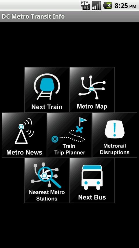
DC Metro Transit - Free - Realtime predictions for Washington DC MetroRail, MetroBus and other local buses
Free (with ads) mobile interface for WMATA:
-Tablet friendly layout (Honeycomb Compatibility)
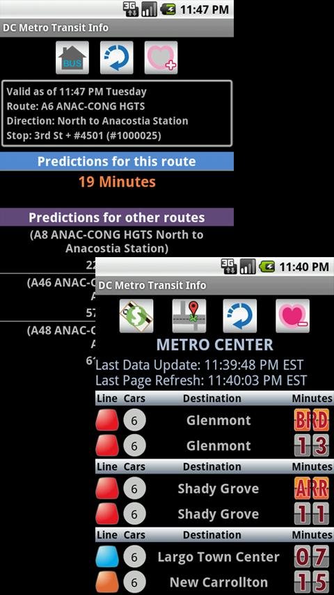
-Real-time predictions: DC Metrorail, Metro Bus, Circulator, PG County-The Bus, Fairfax CUE, UMD Shuttle
-Nearest train stations & WMATA Bus stops by GPS
-Google Maps directions to each of the nearest stations/stops
-Interactive Metrorail Map
-Load StreetView from Metro Map for a station
-Train Trip Planner
-Metro rail disruptions and news
-Important WMATA contact information (press menu on the app home screen)
-Sort your favorite Metro Stations and Bus Stops by dragging the icons to the left of the station name.
-Backup your configuration to the SD card (press menu on the app home screen)
-Restore your configuration from the SD card (press menu on the app home screen)
An ad-free (paid) version is available.
Like it? Share with your friends!
Supported operating systems:
Google Android 10.x, Google Android 2.3, Google Android 3.0, Google Android 3.1, Google Android 3.2, Google Android 4.0, Google Android 4.1, Google Android 4.2, Google Android 4.3, Google Android 4.4, Google Android 5.x, Google Android 6.x, Google Android 7.x, Google Android 8.x, Google Android 9.x
Similar Software:
QMetro Subway World QMetro it's a simple subway map for searching stations and calculating route. About 230 maps of subways are available. Maps have an open format and can easily be edited or created. By default the package includes biggest subways of the World, and you can easy download other available maps into this app
TrafikInfo Android application for showing Swedish traffic information
BlaBlaCar BlaBlaCar - is a fast and easy way to find travel companions. Do you plan your journey but you failed to buy train tickets? Don't be sad because with the help of this application you will easily find travel companions and transport. All you need to do is to specify departure date and the application will carry a search for you
Snarl Traffic The best way to view Australian traffic....and it's free! The popular application now available on Android! Supporting NSW, Victoria and Queensland, Snarl Traffic will provide you with the traffic information you need when you need it
My OC Transpo My OC Transpo - Get out and about in Ottawa and the Valley using the OC Transpo Android application.
View bus routes, stop-specific arrival times, find bus stops near you, use Google Maps to locate stops and view routes, add widget, and plan a trip within the Ottawa region using the quick planner
Stuff - Todo widget Stuff - is the best widget for list to do, which works from the home screen. Add tasks to the list with one tap to easily make a list to do. Moreover, the widget is placed on the screen in such a way that it is convenient for you to use your smartphone
Avtobuser Avtobuser - are you waiting for a bus too long? You will not have to waste your time thanks to this application anymore. Choose the type of vehicle and get the information on its arrival. The application determines your location and can find the nearest stops even if you don't know the exact name
INRIX Traffic - Avoid Traffic Save time, gas and money by avoiding traffic. Winner of MacWorld 2010 Best of Show, INRIX Traffic puts the power of real-time incidents, traffic forecasting and comparative traffic in the palm of your hand