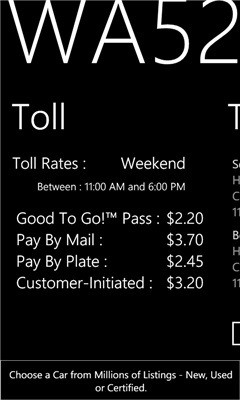
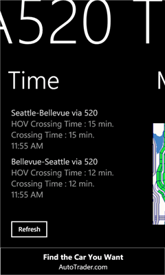
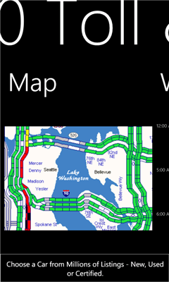
Washington SR 520 Toll & Traffic - Electronic tolling on SR 520 will begin this spring. Be ready by checking how much it will cost you to cross SR 520. Application takes in account US Holidays and provides additional information, such as current crossing time for both directions, and traffic map of the bridges.
Like it? Share with your friends!
If you got an error while installing Themes, Software or Games, please, read FAQ.
Supported operating systems:
Windows 10 Mobile, Windows Phone 7, Windows Phone 8
Similar Software:
Bingle Maps Bingle Maps is a full featured map application. Other than the commonly desired features like Search, Routing and Itineraries, it allows you to drop unlimited personal pins and synchronize them with your DropBox account, not to mention that it also integrates with Google Maps.
Highlights:
- You can choose to use either Bing Maps or Google Maps
Share Location Share Location - Send a map image to your friends by SMS, Email or Twitter. Automatically find your current location or search for a location and then send it. You can also pick a different location by simple tap and hold the map
GMap Pro GMap Pro - Ultimate Google Maps for Windows Phone 7
In new version we have added China region detection and offset auto correction. We have also improved navigation by adding auto rerouting and current step highlighting.
We appreciate your feedback. Help us make tool you’d like
Maps+ Maps+ - Maps Plus (Maps+) is an easy to use, powerful way to find directions, points of interest, locations, and anything else you're looking for
Vicinity Vicinity automatically locates you and businesses within 1 mile of you, providing 0 click access to everything in your Vicinity. Selecting a search result presents you with a detailed view, including a zoomable map with walking route from your current location
MapStalt Mini MapStalt Mini is an application that is meant to bring the map to completeness. In the case of the open street map, many details are missing, and MapStalt puts to power to complete the map into the hands of the mobile user. With MapStalt, a user can add something as simple as a building address and latitude/longitude or complex details such as business hours of operation
Prague Maps Prague Maps - This app contains offline (no data plan/reception necessary) public transportation maps for the Prague area, including tourist maps, metro/tram maps, and the Airport Express, which takes you from Prague Airport to popular the main train station, Hlavni Nadrazi
Wenak Mobisoft Wenak lets you share your location with your friends, family members, co-workers and loved ones by making it easy to tell them where you are and see each other on the map.
Wenak lets you share your location in the background, even when the app is closed
AGMapTime AGMapTime is a simple viewer with time slider features for "time-aware" layer data of ArcGIS services. Time slider lets you browse map features on specific time. You can view various kind of map layers from ArcGIS.com or your own ArcGIS server.
version 0.5 (First version)
- Only supports dynamic layer.
- Fixed base map.
- Slider auto detect time duration
Other Software by developer «Peter Dotsenko»:
not found
Comments on Washington SR 520 Toll & Traffic:
Comments not found
If you noted an error or download link is broken, please, report it via this page or use comments.
Washington SR 520 Toll & Traffic is compatible with your device Windows Phone 7