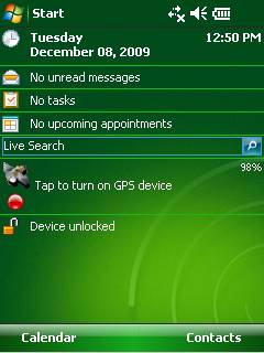
GPS2day is a today screen plug-in showing your current GPS coordinates, speed, satellite info, etc... Languages: English, Czech, Dutch, French, German, Hungarian, Italian, Japanese, Polish, Russian, Spanish.
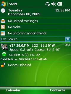
Currently GPS2day program works as GPS informer. It supports both metric and U.S. (Imperial) units and shows a various types of information for users, such as:
Current geographical coordinates (latitude, longitude);
Course and speed;
Some information about satellites and fix type;
Altitude followed by the fix 3D value;
Exact current date and time from the satellite atomic clock;
And battery life state which is important when you using GPS device.
What's New in This Release:
· Translation to Japanese was added
Like it? Share with your friends!
If you got an error while installing Themes, Software or Games, please, read FAQ.
Supported operating systems:
Windows Mobile 5.0, Windows Mobile 6 Classic, Windows Mobile 6 Professional, Windows Mobile 6.1 Classic, Windows Mobile 6.1 Professional, Windows Mobile 6.5 Professional
Similar Software:
TravelGPSes TravelGPSes uses the GPS on your PocketPC to find your current latitude/ longitude/ speed and altitude and looks up the Tixik.com GPS listings and displays them. Tap the button to start the GPS and when you get the lock tap the button again to view the Tixik.com listings for the area. This service is provided by Tixik
FON Access Points for French Polynesia FON Access Points for French Polynesia - FON offers you a new Points of Interest service (POIs). This allows you to download FONspots directly to your navigation device.
What does that mean? You can download a Points of Interest file directly to your navigation device
TTSGpser TTSGpser - TTSGpser uses text-to-speech to tell you the current GPS coordinates.
To use the app, simply run it, wait for the program to get a GPS lock, and then press the button to hear your location spoken in a female voice.
The application uses Google's TTS engine
Glympse Glympse is the easiest, most flexible way to safely share your location. Just a couple clicks, and you can decide who and for how long your friends can see your location on a map.
How it works:
Send a Glympse - Share your location from a mobile smartphone.
Receive a Glympse - View a shared location on either a computer or mobile smartphone
RunSat GPS Sports Application - complete with autopause, autolap and upload to runsaturday.com
SportyPal SportyPal is an easy to use intuitive application for your mobile device. You activate it when you start your running, cycling, walking, rollerblading or similar exercise. In two simple clicks it will start to log and map your position, movement, distance, tempo and calories burned
Gps Runner Track An application for Windows Mobile devices with GPS to keep tracks of your runs
VirtualGPS Virtual GPS is a free, small utility, which fully emulates GPS module and returns your location (by using cellular towers).
Accuracy of coordinates is about 200m in urban area and up to 5km in countryside. Screenshots are explaining how to use VirtualGPS with navigation software (e.g. "Google Maps")
NaviPOWM NaviPOWM is a car navigation system capable of running on a variety of operating systems. Only OSM based map data is supported. Realtime routing engine is planned in a later version. Geocaching and city guide functionality are also planned
FON Access Points for Turkey FON Access Points for Turkey - FON offers you a new Points of Interest service (POIs). This allows you to download FONspots directly to your navigation device.
What does that mean? You can download a Points of Interest file directly to your navigation device
Other Software by developer «Soft Expanse Group»:
ShellSwitcher ShellSwitcher was implemented as a Windows Mobile system utility for fast switching between well known shells: Spb Mobile Shell, Titanium (WM6.5 default shell), Touch Flo 3D, HTC Sense and classic Today screen. This application is based on UI Switcher knowledge with some additional features