Vienna Metro 10 - The new Zuti Vienna Metro map makes it easy to travel in and around the city using the Metro (U-Bahn), Suburban Rail (S-Bahn) or Tram (Straßenbahn) systems. Unlike old fashioned schematic style maps this product contains a geographically accurate central area showing major streets, parks and places of interest etc, allowing the user to easily get their bearings.
MAP
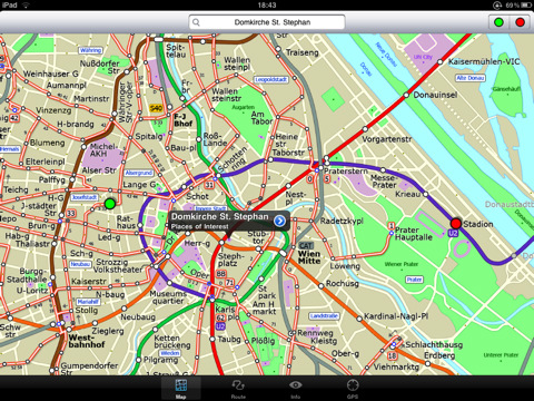
The map is hand drawn by Visual IT and provides a unique geographically based view of Vienna with many places of interest drawn directly on the background so you can easily get your bearings when traveling around the city. You can also use your inbuilt GPS to accurately locate and track yourself within the city centre and see the nearest transportation stop and distance to it. This is the only pubic transportation route planner with this ability.
Tap on the map for location information, use the inbuilt search feature or choose from a list of locations. Places of interest, museums, hotels, parks, restaurant, shops, hospitals, streets, etc, are also included. The route planner will automatically suggest the nearest station to any place of interest you select.
MINUTE MAP
Another great feature is the “Minute Map” option which allows you to see the travel times from a start point to all other locations on the map. This is a unique way to view the topology of a city and gauge traveling times.
ROUTING
The application does not require an internet connection and will always be available to display a clear and detailed view of the city transport systems, plus list and animate the optimum route for your journey. This product provides the fastest route calculations of any mobile routing application (virtually instantaneous) using actual published journey times with the ability to select the quickest route or the route with the least changes.
What's New in This Release:
· Improved user interface.
· Save and recall favourite routes.
· Instant Minute Map from any tap location.
· Show any transport service drawn on the map.
· Minor map updates.
Like it? Share with your friends!
If you got an error while installing Themes, Software or Games, please, read FAQ.
Supported operating systems:
Apple iOS 10.x (iPad), Apple iOS 11.x (iPad), Apple iOS 12.x (iPad), Apple iOS 4.2.x (iPad), Apple iOS 4.3.x (iPad), Apple iOS 5.0 (iPad), Apple iOS 6.0 (iPad), Apple iOS 7.0 (iPad), Apple iOS 8.x (iPad), Apple iOS 9.x (iPad), Apple iPhone OS 3.2.x (iPad)
Other Software by developer «Visual IT»:
Tube 2 Los Angeles (UIQ3) Tube 2 Los Angeles (UIQ3) - This map package for Tube 2 consists of a fully scrollable detailed map of the Los Angeles rail system.
Plan journeys on this system, list details of the quickest routes and see a superb animated display of your journey tracking around the system map
TUBE 2 New York City (Blackberry) TUBE 2 New York City (Blackberry)
Tube 2 New York City
Transform your Blackberry into a fully scrollable detailed map of the New York City MTA subway system.
Plan journeys on the New York City subway system, have the quickest routes to hand, with all the details you need including line changes, platform directions and accurate journey times
London Visitors A-Z London Visitors A-Z - The London Visitors Map of central London is designed especially for the tourist. The principal feature of the mapping is the highlighting of places of interest, buildings open to the public, theatres, cinemas, selected shops and stores, main shopping streets, main line and underground railway stations and other locations of interest to the visitor
Tube San Francisco (Series 60) Tube San Francisco (Series 60) - Our highly acclaimed Tube application that guides you around the BART system of San Francisco is now available for your Series 60 Symbian powered phone. An essential addition to your phone for locals and tourists alike.
· A detailed clear colour map of the San Francisco BART system fully scrollable
Tube Washington (Series 60) Tube Washington (Series 60) - Our highly acclaimed Tube application that guides you around the Washington D.C. metro system is now available for your Series 60 Symbian powered phone. An essential addition to your phone for locals and tourists alike.
· A detailed clear colour map of the transport system fully scrollable.
· Quick find station utility
London Congestion Charge Map (UIQ3) London Congestion Charge Map (UIQ3) - This map package is an essential addition to your Tube 2 maps if you drive in or around central London.
This reference map gives you a clear view of the area now covered by the congestion charge system, complete with a quick find utility to help you find any major road or street in and around the area
Tyne & Wear Metro for iPad by Zuti Tyne & Wear Metro for iPad by Zuti - The new Tyne & Wear Metro map makes it easy to travel in and around the city using the Nexus Metro system. Unlike old fashioned schematic style maps this product contains a geographically accurate central area showing major streets, parks and places of interest etc, allowing the user to easily get their bearings
Tube 2 London (UIQ3) Tube 2 London (UIQ3) - This map package for Tube 2 consists of a fully scrollable detailed map of the London Underground system.
Plan journeys on the London Underground system, list details of the quickest routes and see a superb animated display of your journey tracking around the system map
Tube 2 Berlin (UIQ) Tube 2 Berlin (UIQ) - This map package for Tube 2 consists of a fully scrollable detailed map of the Berlin Metro (U-Bahn/S-Bahn).
Plan journeys on this system, list details of the quickest routes and see a superb animated display of your journey tracking around the system map.
Berlin is the capital and largest city in Germany
Tube Vienna (iPhone) Tube Vienna (iPhone) is a superb interactive guide to the Vienna Metro (U-Bahn) and Vienna Tram (StrassenBahn) systems.
With no need for an internet connection Tube Vienna will always be available to display a clear and detailed view of the city transport systems, plus list and animate the optimum route for all your journeys


")
")

")
")
")

")
")
")