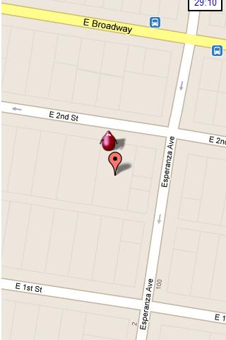
Hunting the Snark - Inspired by Lewis Carrol's poem, The Hunting of the Snark, Hunting the Snark is an action game played on both your GPS-enabled Android device and in the real world. In it, you hunt a Snark (the creature on the map in blue.) If you invade its physical location before the game time has expired, you win. Otherwise, you lose. Also, at random intervals the Snark becomes a Boojum. Your device will vibrate and the creature will turn red, and it will then attack you until a random interval expires, at which time it will become a Snark again. If, as a Boojum, it invades your physical space, you lose.
NOTE: the accuracy of the game is around 3 yards (2.5 meters.) Keep this in mind when you have the map zoomed in close.
Please play responsibly, in areas of low traffic. Adult supervision is recommended.
In the menu, you can pause or stop the game, start a new one, change the screen's orientation, and modify the settings, which include the Snark's speed, the game time, whether the Snark must remain within the region of the map, and the type and zoom-level of the map. Also, you can move the map around with your finger.
This game requires Internet access and an active GPS service, and your device must be facing an open sky. It is also STRONGLY recommended that you turn off other locator services. Though this may be dependent on your particular location and your service provider. The app has been tested on Android 2.2. It may or may not work on other systems.
What's New in This Release:
· Changed character design and animation
· Improved user notifications
· Minor UI improvements
· Replace AdSense with AdMob
Like it? Share with your friends!
Supported operating systems:
Google Android 10.x, Google Android 2.2, Google Android 2.3, Google Android 3.0, Google Android 3.1, Google Android 3.2, Google Android 4.0, Google Android 4.1, Google Android 4.2, Google Android 4.3, Google Android 4.4, Google Android 5.x, Google Android 6.x, Google Android 7.x, Google Android 8.x, Google Android 9.x
amAze GPS light edition amAze GPS light edition provides access to worldwide street maps, full topographic map coverage of the USA and satellite imagery for 200 major cities around the world. It allows you to search in a worldwide rich POI database and you can upgrade to the full version that includes turn-by-turn voice guided navigation from within the application
LocationFinder LocationFinder is a LBS application. Through this application you can search any location in map. Click anywhere in map and you find the area, nearest city and country. Apart from this, user can edit any location for search and can see the location in map
Naver Maps Naver Maps - Smarter than ever! Experience Naver Map for Android. You can find the shortest way to get to your destination, using public transportation even it is far away. You can also search the information on the area around you easily and check whether you are heading to your destination correctly with GPS and compass
Hansel and Gretel Backtracking GPS Hansel and Gretel Backtracking GPS - A simple and highly effective backtracking GPS that does not require a network connection or maps. Hansel and Gretel will remember any location. When it is time to return just follow the arrow or radar image. If only the fairy tale characters had downloaded this app...
From DS Software, the leader in quality mobile navigation tools
Outdoor Share for Android Outdoor Share for Android - The Outdoor Navigation software is your best friend through your adventures in the wild.
Go into the outdoors with confidence and enjoy your activities without worrying about the tools to help you navigate. Your Outdoor Navigation app is made by the people who have been developing this software since 2003 across multiple platforms
amAze (Android) AmAze is a first of its kind free navigation and local search service. It is free to download and use and it contains wide coverage of maps including aerial photo in Europe, North America, Australia and parts of Asia and Africa
amAze (Motorola) AmAze is a first of its kind free navigation and local search service. It is free to download and use and it contains wide coverage of maps including aerial photo in Europe, North America, Australia and parts of Asia and Africa
FindShip FindShip - Find any ship all over the world! With FindShip, you can track your vessel' movements realtime on the mapFeatures:• * Nearly 80,000 ships online.• * Covering most ports on the world.• * Detail ship's information. In addition to AIS information, D.W.T/Gross ton/Build year is also provided.• * Powerfull ship/port search engine
Android Photo GeoTag Android Photo GeoTag - Take pictures with your mobile phone and incorporate the data of the geographical location. The application allows you to include in the photographs, data from the GPS receiver, along with a brief note. If you know the coordinates, not having the GPS receiver, you can also handwrite geographic data
Other Software by developer «Colin Cohen»:
not found
Comments on Hunting the Snark:
Comments not found
If you noted an error or download link is broken, please, report it via this page or use comments.
Hunting the Snark is compatible with your device T-Mobile REVVL 4+ TD-LTE US 5062W / 5062Z (TCL 5062)

")


")
")
