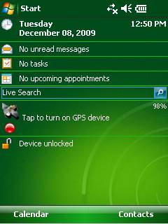
GPS2day is a today screen plug-in showing your current GPS coordinates, speed, satellite info, etc... Languages: English, Czech, Dutch, French, German, Hungarian, Italian, Japanese, Polish, Russian, Spanish.
Currently GPS2day program works as GPS informer. It supports both metric and U.S. (Imperial) units and shows a various types of information for users, such as:
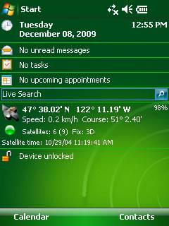
Current geographical coordinates (latitude, longitude);
Course and speed;
Some information about satellites and fix type;
Altitude followed by the fix 3D value;
Exact current date and time from the satellite atomic clock;
And battery life state which is important when you using GPS device.
What's New in This Release:
· Translation to Japanese was added
Like it? Share with your friends!
If you got an error while installing Themes, Software or Games, please, read FAQ.
Supported operating systems:
Windows Mobile 5.0, Windows Mobile 6 Classic, Windows Mobile 6 Professional, Windows Mobile 6.1 Classic, Windows Mobile 6.1 Professional, Windows Mobile 6.5 Professional
Similar Software:
GPSmeter Do you still use your GPS device for navigating only?
Turn your Pocket PC into a high precision metering machine using your GPS receiver! With MASPware GPSmeter you can measure short and long distances (beeline or routelength), altitude differences, timespans, average values and min-max-values using an internal or external GPS receiver
Community Megaphone Reader Community Megaphone Reader - This application is part of the author's "30 Days of .NET" initiative to develop 30 mobile applications in 30 days. The source code of the application is included in order to help programmers new to Windows Mobile development write applications in .NET
FON Access Points for Turkey FON Access Points for Turkey - FON offers you a new Points of Interest service (POIs). This allows you to download FONspots directly to your navigation device.
What does that mean? You can download a Points of Interest file directly to your navigation device
Terracrosser Terracrosser is a free GPS navigation software for Windows Mobile Pocket PC.
· Terracrosser works in Map and Photo modes
· Terracrosser uses zoomable maps
· Terracrosser is completely compatible with Google Maps service. With included Mapper module you can download maps from the Internet
FilesGPSs FilesGPSs - FilesGPSs allows you to browse the GPS Picture/Video/Voice/Text etc. tagged files that are on your PocketPC. You can create and download a Google.com map of the folder or view each file on Google.com maps.
This program requires that you have both the 'BeanDLL.dll' file ** and ** the runtime files for Visual Basic on your PocketPC computer
FON Access Points for Ecuador FON Access Points for Ecuador - FON offers you a new Points of Interest service (POIs). This allows you to download FONspots directly to your navigation device.
What does that mean? You can download a Points of Interest file directly to your navigation device
TravelCompasses TravelCompasses - TravelCompasses uses the GPS on your PocketPC to find a "Home" position. Then the program displays a compass that rotates to your current GPS. The program also displays your current compass degrees.
This program requires that you have both the 'BeanDLL.dll' file ** and ** the runtime files for Visual Basic on your PocketPC computer
GPS Dashboard GPS Dashboard- View the status of the GPS on your phone with this cool Dashboard
FON Access Points for Saudi Arabia FON Access Points for Saudi Arabia - FON offers you a new Points of Interest service (POIs). This allows you to download FONspots directly to your navigation device.
What does that mean? You can download a Points of Interest file directly to your navigation device
Other Software by developer «Soft Expanse Group»:
ShellSwitcher ShellSwitcher was implemented as a Windows Mobile system utility for fast switching between well known shells: Spb Mobile Shell, Titanium (WM6.5 default shell), Touch Flo 3D, HTC Sense and classic Today screen. This application is based on UI Switcher knowledge with some additional features

")