Platforms: iPhone, iPad, iPod Touch, Apple iPhone OS
Categories: Games
Upload date: 29 Nov 11
Developer: VITO Technology
License: Freeware
Downloads: 92
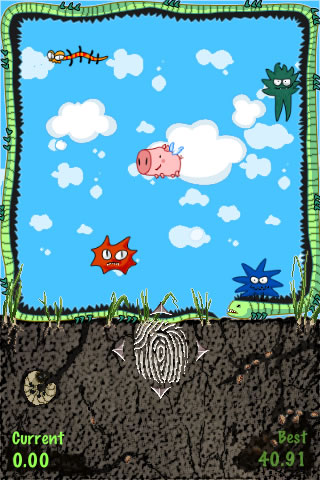
Swine Time - Get rid of the Swine Flu panic with this fast, easy, funny reaction game.
Ever imagined to be a pig those days? Swine flu, H1N1 virus are more than enough to have everybody against you. It can be difficult to survive as a pig in today's society, even if you are a "flying pig"! Everybody is following you around, doesn't let you go anywhere and wants to corner you!
Try your hand eye coordination to save the little flying pig from the dangerous monsters. All you have is your own reaction and your finger control. Test your reflexes and make the pig fly as long as possible to become a record breaker.
How to play:
Put your finger on the finger print sign, start moving the little flying pig and try to avoid the monsters. See how fast you can react escaping them and how long the pig survives before being taken to emergency treatment. Save your scores and name on the high scores rank and click on time to watch yours and other players' replay.
Hot Features:
Replay to look and learn top performances
Live online high scores update to track your world position
Speed increase to make the action really hot
Play against your personal best
Enjoy playing with your friends, kids, colleagues or against the world and see how people react under pressure. Check how fast they can move and who can set the best time. Save your name on the high scores rank and check who you beat or is ahead of you.
You can also watch the other games played by record setters with the replay button and learn their tactics.
Like it? Share with your friends!
If you got an error while installing Themes, Software or Games, please, read FAQ.
Supported operating systems:
Apple iOS 10.x (iPad), Apple iOS 10.x (iPhone), Apple iOS 11.x (iPad), Apple iOS 12.x (iPad), Apple iOS 12.x (iPhone), Apple iOS 4.0.x (iPhone), Apple iOS 4.0.x (iPod Touch), Apple iOS 4.2.x (iPad), Apple iOS 4.2.x (iPhone), Apple iOS 4.2.x (iPod Touch), Apple iOS 4.3.x (iPad), Apple iOS 4.3.x (iPhone), Apple iOS 4.3.x (iPod Touch), Apple iOS 5.0 (iPad), Apple iOS 5.0 (iPhone), Apple iOS 5.0 (iPod Touch), Apple iOS 6.0 (iPad), Apple iOS 6.0 (iPhone), Apple iOS 6.0 (iPod Touch), Apple iOS 7.0 (iPad), Apple iOS 7.0 (iPhone), Apple iOS 7.0 (iPod Touch), Apple iOS 8.x (iPad), Apple iOS 8.x (iPhone), Apple iOS 8.x (iPod Touch), Apple iOS 9.x (iPad), Apple iOS 9.x (iPhone), Apple iOS 9.x (iPod Touch), Apple iPhone OS 3.1.x, Apple iPhone OS 3.1.x (iPod Touch), Apple iPhone OS 3.2.x (iPad)
Other Software by developer «VITO Technology»:
Map of Wisconsis (US State) Map of Wisconsis (US State) - A map of the Wisconsis by VITO Technology. Good for intercity travels with SmartMap.
SmartMap is a mobile device application which uses vector and raster maps. It is compatible with any NMEA protocol GPS receiver (Compact Flash socket, serial port, BlueTooth or sleeve)
Map of Syria Map of Syria - A map of Syria, divided into 12 smaller territories for the ease of use. Good for intercity travels with SmartMap. Layers include:
Towns
Settlements
Airports
Roads
Railroads
Rivers
Inland water
Administrative borders
International borders
Trees
Map scale is 1:1 million
Map of Oman Map of Oman - A map of Oman, divided into 8 smaller territories for the ease of use.
MUSANDAM
AL BATINAH
AL ZANIRAH
MASQAT
AD DAKHILIYAH
ASH SHARQIYAH
AL WUSTA
ZUFAR
Good for intercity travels with SmartMap
Star Walk for Android Star Walk for Android - Star Walk is an astronomy application that can help you to easily identify stars, planets, satellites and constellations using your Android smartphone or tablet. Simply point your mobile device towards the night sky and the app will show you a star map on the screen of your phone using augmented reality
Map of Slovenia Map of Slovenia - A map of Slovenia. Good for intercity travels with SmartMap.
Layers include:
Towns
Settlements
Airports
Roads
Railroads
Rivers
Inland water
Administrative borders
International borders
Trees
Map scale is 1:1 million.
Good for use with any version of SmartMap. SmartMap can be purchased here
VITO Voice2Go Voice2Go is a voice control application for Pocket PC that allows you to manage your Pocket PC with voice commands! Starting and quitting applications, calling contacts, opening system settings, pressing any screen buttons with your voice and launching macros
Map of North Dakota (US State) Map of North Dakota (US State) - A map of the North Dakota by VITO Technology. Good for intercity travels with SmartMap.
SmartMap is a mobile device application which uses vector and raster maps. It is compatible with any NMEA protocol GPS receiver (Compact Flash socket, serial port, BlueTooth or sleeve)
Map of Sri Lanka Map of Sri Lanka - A map of Sri Lanka. Good for intercity travels with SmartMap.
Layers include:
Towns
Settlements
Airports
Roads
Railroads
Rivers
Inland water
Administrative borders
International borders
Trees
Map scale is 1:1 million.
Good for use with any version of SmartMap. SmartMap can be purchased here
Map of Rhode Island (US State) Map of Rhode Island (US State) - A map of the Rhode Island by VITO Technology. Good for intercity travels with SmartMap.
SmartMap is a mobile device application which uses vector and raster maps. It is compatible with any NMEA protocol GPS receiver (Compact Flash socket, serial port, BlueTooth or sleeve)


")


")


")