Map Mobile Navigator (MapNav) is a powerful navigation tool for mobile phones with GPS-receivers (Bluetooth or embedded).
What's New in This Release:
· Displays sunrise/sunset time for specified point on Earth in Information screen
· Sport Mode - auto calc lap time and distance with round run
· Record voice for Marks
· Autobackup track to file in Work path. Enables in Settings-Track. In case of backup error track points count displayed on red background
· Tracking services now supported by netradar.ru only so register there for free to use tracking, track upload to inet and OSM, GT Results analysis and more. Login and password from netradar.ru required not from mapnav.spb.ru
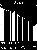
· Add screen Variometer. Displays altitude speed (in m/s only) and altitude (in m).
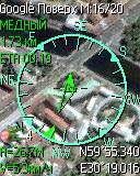
· Screen Position shows UTC time from GPS with phone one together
· Export and import route/track in format GPX 1.1
· Network connection as NMEA source. Select type Socket and enter address like (host:port):127.0.0.1:5720
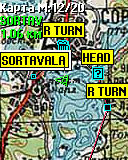
· Turn direction at next waypoint
· Added two online maps with customizable url so you need to specify tile address type
· GT Mode - acceleration measurement by speed and distance, sending to site
· TR-102 Mode - GlobalSat TR-102 emulation (no checksum yet)
· Screen mode HSI fixed, line with arrow is always displaying current step course when wpt cursor showing direction to waypoint
Like it? Share with your friends!
Requirements:· MIDP 2.0, CLDC 1.1
· GPS receiver
Supported operating systems:
Java ME, Java Nokia 240x320, Java SE 240x320
Similar Software:
eGPSTrack eGPSTrack is a GPS tracking application for mobile devices supporting J2ME connected with a Bluetooth GPS receiver. It isn't a navigator, the purpose is to be a positioning tool to be used in mountain to know where you are in each moment and to store the route that you are doing. Specially used for trekking, hiking and bike routes
FON Access Points for Dominican Republic FON Access Points for Dominican Republic - FON offers you a new Points of Interest service (POIs). This allows you to download FONspots directly to your navigation device.
What does that mean? You can download a Points of Interest file directly to your navigation device
GpsMid Afghanistan GpsMid is a free, fully offline, vector based map application for your mobile phone. It displays your current position on a zoomable map and can be used to search for and navigate to roads or points of interest of your liking. As all data is stored in a compact binary format on your mobile phone you will incur no charges for extra data downloads
GpsMid India GpsMid is a free, fully offline, vector based map application for your mobile phone. It displays your current position on a zoomable map and can be used to search for and navigate to roads or points of interest of your liking. As all data is stored in a compact binary format on your mobile phone you will incur no charges for extra data downloads
GpsMid United Arab Emirates GpsMid is a free, fully offline, vector based map application for your mobile phone. It displays your current position on a zoomable map and can be used to search for and navigate to roads or points of interest of your liking. As all data is stored in a compact binary format on your mobile phone you will incur no charges for extra data downloads
How to GPS Tracking a Cell Phone Read on after the jump to learn how to locate that lost phone or errant child. If you've lost your phone, or you're worried about what your child might be up to after school, you can use GPS technology to track a phone and locate it with pinpoint accuracy
GpsMid Syria GpsMid is a free, fully offline, vector based map application for your mobile phone. It displays your current position on a zoomable map and can be used to search for and navigate to roads or points of interest of your liking. As all data is stored in a compact binary format on your mobile phone you will incur no charges for extra data downloads
Map My Tracks Map My Tracks turns your mobile phone into your personal real-time GPS tracking device. Using a mobile phone with built-in GPS or an external GPS receiver you can map and track your location in real-time. Map My Tracks is great for bringing a new insight into your sporting activity, it provides a competitive edge and makes training fun
GpsMid Rhein-Main (Giessen - Heidelberg) GpsMid Rhein-Main (Giessen - Heidelberg) is a free, fully offline, vector based map application for your mobile phone. It displays your current position on a zoomable map and can be used to search for and navigate to roads or points of interest of your liking
TrekBuddy Trekbuddy is a J2ME application to be used with a GPS receiver. It is designed to work with every Java-enabled device. It features capabilities such as: * GPS tracking and simple navigation * bitmap maps (without zoom, you can store bitmap maps with different resolution instead)
Other Software by developer «Pavel Raev»:
not found
Comments on Map Mobile Navigator (MapNav):
saber:
Travelers
Date: 30 Jul 17
If you noted an error or download link is broken, please, report it via this page or use comments.
Map Mobile Navigator (MapNav) is compatible with your device Sony Ericsson K610i


")
")


")
