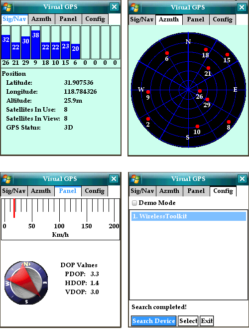
J2ME Bluetooth GPS Compass - Bluetooth GPS compass is a free J2ME application that displays GPS data graphically . features include satellite azimuth/elevation, GPS signal quality, analog gauges.
Like it? Share with your friends!
Supported operating systems:
Java ME, Java Nokia 240x320, Java SE 240x320
speedTracker (Java) speedTracker (Java) - Use this software, to track bandwidth/downloadrate, latency and GPS values from your mobile device.
speedTracker contains two Java-based applications:
* speedTracker Mobile Edition - a J2ME application for GPS mobiles (ex
GpsMid Georgia GpsMid Georgia is a free, fully offline, vector based map application for your mobile phone. It displays your current position on a zoomable map and can be used to search for and navigate to roads or points of interest of your liking. As all data is stored in a compact binary format on your mobile phone you will incur no charges for extra data downloads
City Cruiser City Cruiser is a GPS navigation application for mobile phones that provides voice-guided turn-by-turn navigation on top of real-time 3D maps
GpsMid Germany, Schleswig-Holstein GpsMid Germany, Schleswig-Holstein is a free, fully offline, vector based map application for your mobile phone. It displays your current position on a zoomable map and can be used to search for and navigate to roads or points of interest of your liking. As all data is stored in a compact binary format on your mobile phone you will incur no charges for extra data downloads
FON Access Points for Thailand FON Access Points for Thailand - FON offers you a new Points of Interest service (POIs). This allows you to download FONspots directly to your navigation device.
What does that mean? You can download a Points of Interest file directly to your navigation device
FON Access Points for Antarctica FON Access Points for Antarctica - FON offers you a new Points of Interest service (POIs). This allows you to download FONspots directly to your navigation device.
What does that mean? You can download a Points of Interest file directly to your navigation device
POIAlert POIAlert indicates so called POIs (Points of Interest) by voice and display output. A POI can be any point with known GPS coordinates (danger place, restaurant, gas station etc.).
POI data can be loaded e.g. from several Internet sources. At present especially red light and speed cameras are supported
GpsMid Midlands and Northern England GpsMid Midlands and Northern England is a free, fully offline, vector based map application for your mobile phone. It displays your current position on a zoomable map and can be used to search for and navigate to roads or points of interest of your liking
Comments on J2ME Bluetooth GPS Compass:
Comments not found
If you noted an error or download link is broken, please, report it via this page or use comments.
J2ME Bluetooth GPS Compass is compatible with your device Sony Ericsson K610i