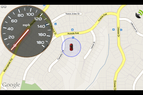
EV Speedo is a GPS based speedometer with gadgets to provide g-force and other GPS information.
A built in map is also provided and any of the gauges provided can be overlayed upon the map, for example use the map to show your location with a speedometer to show your current speed.
A quick left or right swipe of the screen will move to a new pane that can have different set of gauges. 3 panes are available.
Long press on a gadget will show a menu to resize, calibrate, remove or add satellite view to map.
Tap on a gauge or car on map to show current reading.
What's New in This Release:
· Removed Paypal donate. Added Link to market.
What's New in 1.2.5:
· Minor fixes
Like it? Share with your friends!
Supported operating systems:
Google Android 10.x, Google Android 2.0, Google Android 2.1, Google Android 2.2, Google Android 2.3, Google Android 3.0, Google Android 3.1, Google Android 3.2, Google Android 4.0, Google Android 4.1, Google Android 4.2, Google Android 4.3, Google Android 4.4, Google Android 5.x, Google Android 6.x, Google Android 7.x, Google Android 8.x, Google Android 9.x
Similar Software:
ViewRanger GPS ViewRanger is a unique mapping, navigation, tracking, and information tool for mobile phones that provides fully featured outdoor gps and trail navigation through a natural and intuitive display. ViewRanger transforms a Nokia or other Symbian S60 smartphone into a fully featured trail navigation system
amAze (LG) AmAze is a first of its kind free navigation and local search service. It is free to download and use and it contains wide coverage of maps including aerial photo in Europe, North America, Australia and parts of Asia and Africa
Location Finder Place Search Location Finder Place Search - This Free place finder application automatically detect your current location and shows best places around you. This app will show you all available ATM, Bus Stands, Service centers, Airport, Food Services etc. around the current location. Download this free app on your smartphone and just simplified your place search
My Tracks My Tracks - Use My Tracks while you run, bike, hike, or do anything else outdoors, and it will use the GPS sensor in your Android phone to record the path you took. It will also gather useful statistics such as time, speed, distance, and elevation. You can review all of this data live, or you can save it for use later
amAze (Motorola) AmAze is a first of its kind free navigation and local search service. It is free to download and use and it contains wide coverage of maps including aerial photo in Europe, North America, Australia and parts of Asia and Africa
Pocket Caddy Pocket Caddy - #1 Golf GPS app: 3D flyover of holes, yardage to greens, shot recording, stats, scorecard, hazard carry or lay up position. Positioning is shot to hole, not cart to hole. Free PC Analytics inc. 3D Google Earth replay with stats, and Free DIY Course Mapping software both available from www.satsportsna
Wiot lite Wiot lite -is an application which will track your locations with the help of sattelite monitoring system. The application indicates your current GPS position and sends them to the server. You will always know where your close people are
Maps In My Pocket (MIMP) Maps In My Pocket - The main goal of this application is to allow its users to view maps, locate themselves, follow KML or GPX formatted tracks and getting directions from place to place.
What's New in This Release:
· New Icon
What's New in 1.4.3:
· Long press and long pinch concurrency on info bubble solved
MapMyHike+ for Android MapMyHike+ for Android - MapMyHike is a mobile assistant designed to allow hikers to track their activities using their phone's built-in GPS.
With the app you can view your route on a map and record your trip details, including duration, distance, pace, speed and elevation.
You can also share the details of your activity with friends via Facebook, Twitter or email
YGPS Satellites YGPS Satellites - YGPS Satellites is a small mobile application that allows you to easily assess the quality of your GPS signal. The utility displays the location of all the GPS satellites and shows the signal strength for every one of them.
Using the app is pretty straightforward
Other Software by developer «AutoRad Industries»:
Street Race Street Race - App for timing 1/4 mile runs and 0-60mph sprints. Upload your best timings and compare with results from other drivers.
Speedometer operates off phone GPS service. Accuracy is dependent on your phone and satellite reception.
To do a timing run, touch on of the buttons on the first screen
Sub Speedo Sub Speedo - Car Speedometer, KPH, MPH, Lat-G, Acceleration, GPS Info. Highly configurable!
Use with Google Maps tracking view and speedometer at the same time! Map includes Foursquare search to find and discover local amenities.
Swipe, long click and menu to configure screens. Tap to get current reading. Resize gauges to suit screen


")


")


")


