View a large quick reference World Map on your Android today!
Contains Up-To-Date World Maps!
Did you know?
-------------
South Sudan became the world's 195th country following separation from Sudan on 9 July 2011
Features
---------
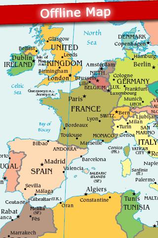
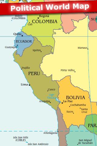
- Political World Map
- No internet connection is required. The map is stored on your Android and can be viewed Offline.
View the World Map quickly and easily on your Android today!
Keywords: Globe, Country, Countries, USA, Atlas, Ocean, Sea, Time Zone, Geography, Topographical, Topography, Island
Cities: Tokyo, Seoul, New York, Mumbai, Jakarta, Shanghai, Los Angeles, Cairo, London, Beijing, Dubai
Countries: Afghanistan, Albania, Algeria, Andorra, Angola, Antigua & Deps, Argentina, Armenia, Australia, Austria, Azerbaijan, Bahamas, Bahrain, Bangladesh, Barbados, Belarus, Belgium, Belize, Benin, Bhutan, Bolivia, Bosnia Herzegovina, Botswana, Brazil, Brunei, Bulgaria, Burkina, Burundi, Cambodia, Cameroon, Canada, Cape Verde, Central African Rep, Chad, Chile, China, Colombia, Comoros, Congo, Congo {Democratic Rep}, Costa Rica, Croatia, Cuba, Cyprus, Czech Republic, Denmark, Djibouti, Dominica, Dominican Republic, East Timor, Ecuador, Egypt, El Salvador, Equatorial Guinea, Eritrea, Estonia, Ethiopia, Fiji, Finland, France, Gabon, Gambia, Georgia, Germany, Ghana, Greece, Grenada, Guatemala, Guinea, Guinea-Bissau, Guyana, Haiti, Honduras, Hungary, Iceland, India, Indonesia, Iran, Iraq, Ireland {Republic}, Israel, Italy, Ivory Coast, Jamaica, Japan, Jordan, Kazakhstan, Kenya, Kiribati, Korea North, Korea South, Kosovo, Kuwait, Kyrgyzstan, Laos, Latvia, Lebanon, Lesotho, Liberia, Libya, Liechtenstein, Lithuania, Luxembourg, Macedonia, Madagascar, Malawi, Malaysia, Maldives, Mali, Malta, Marshall Islands, Mauritania, Mauritius, Mexico, Micronesia, Moldova, Monaco, Mongolia, Montenegro, Morocco, Mozambique, Myanmar, {Burma}, Namibia, Nauru, Nepal, Netherlands, New Zealand, Nicaragua, Niger, Nigeria, Norway, Oman, Pakistan, Palau, Panama, Papua New Guinea, Paraguay, Peru, Philippines, Poland, Portugal, Qatar, Romania, Russian Federation, Rwanda, St Kitts & Nevis, St Lucia, Saint Vincent & the Grenadines, Samoa, San Marino, Sao Tome & Principe, Saudi Arabia, Senegal, Serbia, Seychelles, Sierra Leone, Singapore, Slovakia, Slovenia, Solomon Islands, Somalia, South Africa, Spain, Sri Lanka, Sudan, Suriname, Swaziland, Sweden, Switzerland, Syria, Taiwan, Tajikistan, Tanzania, Thailand, Togo, Tonga, Trinidad & Tobago, Tunisia, Turkey, Turkmenistan, Tuvalu, Uganda, Ukraine, United Arab Emirates, United Kingdom, United States, Uruguay, Uzbekistan, Vanuatu, Vatican City, Venezuela, Vietnam, Yemen, Zambia, Zimbabwe
Like it? Share with your friends!
Supported operating systems:
Google Android 1.5, Google Android 1.6, Google Android 10.x, Google Android 2.0, Google Android 2.1, Google Android 2.2, Google Android 2.3, Google Android 3.0, Google Android 3.1, Google Android 3.2, Google Android 4.0, Google Android 4.1, Google Android 4.2, Google Android 4.3, Google Android 4.4, Google Android 5.x, Google Android 6.x, Google Android 7.x, Google Android 8.x, Google Android 9.x
Similar Software:
Google Maps (Android) Google Maps - Now you can get business locations, maps and directions while you're on the go. And it's all free.
· Navigation: Free, voice-guided GPS navigation system using GPS with Google Maps
· Places: Find nearby places and see hours, reviews, etc
yozi yozi is a navigation software for the Android platform. It uses digital topographic maps in well-known Ozi Explorer formats for navigation and doesn't require network access like built-in Maps application on Android
UMichBusMap An Android application which shows the live positions of University of Michigan buses overlayed on Google Maps
amAze (Samsung) AmAze is a first of its kind free navigation and local search service. It is free to download and use and it contains wide coverage of maps including aerial photo in Europe, North America, Australia and parts of Asia and Africa
GoPenS GoPenS is an OpenSource GPS application for Android phones, based on OpenStreetMap (OSM). OpenStreetMap is a collaborative map of the world. Therefore, one of the main functions of the application is to be able to record a trace and send it as a GPX to the OSM servers, and so edit the OSM Map
amAze (Samsung) AmAze is a first of its kind free navigation and local search service. It is free to download and use and it contains wide coverage of maps including aerial photo in Europe, North America, Australia and parts of Asia and Africa
Geosearch Geosearch is a free/open source application which allows you to monitor the movement of users on a Google map. You can send SMS, make calls and find the optimal road to reach another user
Art Places Art Places is a software application for the Android mobile operating system.
The application gets our position through the GPS in the mobile device and shows us our current location in the maps application. of maps
TTC Subway Rider Efficiency Guide TTC Subway Rider Efficiency Guide - This application has maps of all TTC (Toronto Transit Commission) subway stations so you can see where the stairs/etc are... and plan where to stand on the platform.
Based on ttcrider.ca
Useful for handicapped people too

")


")


")

")


