Metro LX is a comprehensive guide to the Lisbon Subway providing:
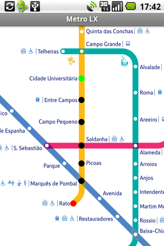
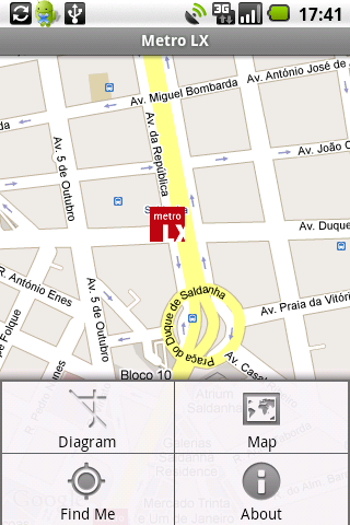
A map of Lisbon Metro (subway) in landscape and portrait modes;
A route planner between stations;
A map route to station from your position;
And detailed information per Station.
What's New in This Release:
· Updated tariff (February 2012);
· Minor bugs fixed on tablets.
What's New in 2.8:
· Improved route to station planner;
· Updated tariff (August 2011);
· 3 new translations (Korean, Chinese and Romanian);
· Minor bugs fixed.
What's New in 2.6:
· Added preferences panel to disable/enable the use of GPS current location;
· Switch orientation crashes fixed.
What's New in 2.4:
· Minor bugs solved.
What's New in 2.3:
· Support for multiple screen sizes and resolutions.
· Layouts slightly restyled.
Like it? Share with your friends!
Supported operating systems:
Google Android 1.5, Google Android 1.6, Google Android 10.x, Google Android 2.0, Google Android 2.1, Google Android 2.2, Google Android 2.3, Google Android 3.0, Google Android 3.1, Google Android 3.2, Google Android 4.0, Google Android 4.1, Google Android 4.2, Google Android 4.3, Google Android 4.4, Google Android 5.x, Google Android 6.x, Google Android 7.x, Google Android 8.x, Google Android 9.x
Similar Software:
jetBlue Get jetBlue on your cell phone or PDA and you'll get instant access to flight status information, weather alerts and even our inflight entertainment and snacks. Take jetBlue wherever you go!
MAPS.ME for Android MAPS.ME for Android - MapsWithMe allows you to access maps of all the countries in the world while on the go. The maps are based on OpenStreetMap data and work completely offline, without requiring an internet connection
TrekBuddy Trekbuddy is a J2ME application to be used with a GPS receiver. It is designed to work with every Java-enabled device. It features capabilities such as: * GPS tracking and simple navigation * bitmap maps (without zoom, you can store bitmap maps with different resolution instead)
Osm2GpsMid GpsMid is a free, fully offline, vector based map application for your mobile phone. It displays your current position on a zoomable map and can be used to search for and navigate to roads or points of interest of your liking. As all data is stored in a compact binary format on your mobile phone you will incur no charges for extra data downloads
UMichBusMap An Android application which shows the live positions of University of Michigan buses overlayed on Google Maps
GoPenS GoPenS is an OpenSource GPS application for Android phones, based on OpenStreetMap (OSM). OpenStreetMap is a collaborative map of the world. Therefore, one of the main functions of the application is to be able to record a trace and send it as a GPX to the OSM servers, and so edit the OSM Map
AugSatNav Walk AugSatNav is an augmented reality navigation system which overlays walking directions upon a live video feed of the path or road ahead.
With AugSatNav there is no need to follow instructions or interpret maps - you can simply find your way by walking along the route highlighted by a bright white line
CoPilot Live South Africa (Android) CoPilot Live South Africa (Android) - Get a CoPilot! The onboard GPS navigation app that makes every journey better
Disaster Alert Disaster Alert (by PDC) - Current global disaster info on an interactive map Disaster Alert (by PDC), Active Hazards on an interactive map and in a list as they are occurring around the globe. Additional hazard information can be viewed and shared
Navigator Navigator - detailed maps with the support of satellite navigation. You need to specify two points to make a route. You can track your current location and set those coordinates as the route start. Thanks to marks on the map you can easily find a fuel station, restaurant or hotel
Other Software by developer «DFX»:
not found
Comments on Metro LX:
Comments not found
If you noted an error or download link is broken, please, report it via this page or use comments.
Metro LX is compatible with your device Samsung SGH-i677 Focus Flash


")

