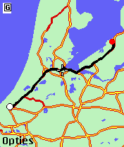
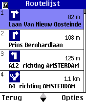
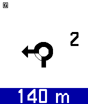
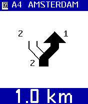
Nav4All (Java) - With Nav4All you can navigate worldwide on your own mobile phone.
You will never lose your way again and you will always know where you and your friends are located.
You get access to over 1 billion addresses on myworld, including Yellow Pages, phonebooks, etc.
While you're on the road you can easily save an interesting location by pressing one button. Or you can take a picture which will be instantly visible on a map on the Myworld website. Your pictures are visible to you or also to your friends, that's up to you.
Like it? Share with your friends!
Supported operating systems:
Java ME, Java Nokia 240x320, Java SE 240x320
Similar Software:
POIAlert POIAlert indicates so called POIs (Points of Interest) by voice and display output. A POI can be any point with known GPS coordinates (danger place, restaurant, gas station etc.).
POI data can be loaded e.g. from several Internet sources. At present especially red light and speed cameras are supported
GpsMid Berlin GpsMid is a free, fully offline, vector based map application for your mobile phone. It displays your current position on a zoomable map and can be used to search for and navigate to roads or points of interest of your liking. As all data is stored in a compact binary format on your mobile phone you will incur no charges for extra data downloads
amAze (Sonim) AmAze is a first of its kind free navigation and local search service. It is free to download and use and it contains wide coverage of maps including aerial photo in Europe, North America, Australia and parts of Asia and Africa
j2me PhotoGeoTag j2me PhotoGeoTag - Take pictures with your mobile phone and incorporate the data of the geographical location. The application allows you to include in the photographs, data from the GPS receiver, along with a brief note. If you know the coordinates, not having the GPS receiver, you can also handwrite geographic data
Tracking - Transportlines Tracking - Transportlines - Live GPS tracking system - Sign up at www.transportlines.com first to get your account - Free Allows for multiple users under your own account. Keeps, speed, direction, time, address of each reported position. Various reports available. Useful for hikers, cyclists, yachting, keeping track of your employees etc.
GpsMid Midlands and Northern England GpsMid Midlands and Northern England is a free, fully offline, vector based map application for your mobile phone. It displays your current position on a zoomable map and can be used to search for and navigate to roads or points of interest of your liking
GpsMid New York City GpsMid New York City is a free, fully offline, vector based map application for your mobile phone. It displays your current position on a zoomable map and can be used to search for and navigate to roads or points of interest of your liking. As all data is stored in a compact binary format on your mobile phone you will incur no charges for extra data downloads
Trackut Trackut is a location based streaming service that will help users create location oriented groups, network with friends and share location tagged data. Trackut streams a variety of information to the mobile users like peer location, local updates, e
FON Access Points for South Africa FON Access Points for South Africa - FON offers you a new Points of Interest service (POIs). This allows you to download FONspots directly to your navigation device.
What does that mean? You can download a Points of Interest file directly to your navigation device
Other Software by developer «Nav4All»:
Nav4All (BlackBerry) Nav4All (BlackBerry) - With Nav4All you can navigate worldwide on your own mobile phone.
You will never lose your way again and you will always know where you and your friends are located.
You get access to over 1 billion addresses on MyWorld, including Yellow Pages, phonebooks, etc
Nav4All (Android) With Nav4All you can navigate worldwide on your own mobile phone.
You will never lose your way again and you will always know where you and your friends are located.
You get access to over 1 billion addresses on MyWorld, including Yellow Pages, phonebooks, etc.
While you're on the road you can easily save an interesting location by pressing one button


")
")


")


")
")