Symbian OS | Pocket PC | Smartphone | Android | BlackBerry | Apple iPhone OS | Java | Mobile Gaming | Linux | Palm | Win CE | Tablet  
     

Free Mobile Software, Themes, Games, Apps for PDA and Smartphones

     
Search by Device
My Device

  
Search by Category
Business & Profession
Databases
Dictionary & Translator
Entertainment
Finance
Games
Healthcare & Medicine
Internet & Communications
Multimedia & Graphics
Organisation & Productivity
Programming & Development
Reading
Science & Education
System Utilities
Themes & Wallpapers & Skins
Travel & Navigation
Geocaching
GPS
Guides
Maps
Measuring & Compass
Travel Planning
Weather
Worldtime
More
Search by Platform
Android
Apple iPhone OS
iPad
iPhone
iPod Touch
BlackBerry
Java
Linux
Maemo Nokia Internet Tablet
MeeGO
Sharp Zaurus
Mobile Gaming
Nintendo DS
Playstation 3
Playstation Portable
Wii
Xbox 360
Palm OS
Symbian OS
Series 60
Series 80
Series 90
UIQ
Tablet PC
Windows CE.NET
Windows Mobile Pocket PC
Windows Mobile Smartphone


Achivx Partner
 
 
WinSportsTracker


WinSportsTracker
Version: 3.18 updated

Platforms: Pocket PC


Categories: Healthcare & Medicine, Travel & Navigation

Upload date: 11 Apr 11

Developer: WinSportsTracker

License: Freeware

Downloads: 3523

File Size: 780 Kb
Download Free WinSportsTracker 


Rating: 2.9/5 (Total votes: 17)


WinSportsTracker is an intuitive easy to use application with powerful capabilities for touch screen Windows mobile professional phones. It is for everyone who enjoy outdoor sport activities like running, cycling, skiing, sailing, riding, hiking, rollerblading...It logs your activity speed, distance, altitude, position and many more and show on dashboard, graph or map (up to 7 views). You can save track logs for later review or export on PC (view on Google Earth, etc). WinSportsTracker helps you to improve your performance in sports. It will not affect normal operation of your mobile phone during use.

Why buy expensive sport tracking gear if you can install FREE program on your windows mobile phone?

Main program features:
-Up to 7 different tracking views
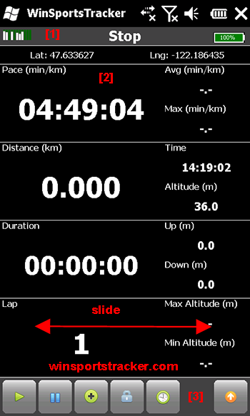
· Display speed, altitude, distance, duration, laps, calorie burn, laps statistics (current, average, max, graph display...)
· Upload to website winsportstracker.com. You can share workout with friends on Facebook
· Support different activities (running, cycling, skiing, riding, sailing,...)
· Off-road navigation. You can import route in GPX format and follow route (bearing or direction to selected point).
· Offline maps, you can download maps (OpenStreetMaps, Google maps,…) in advance on computer no need for internet connection on phone or data plan. Read FAQ on website how to download maps.
· GPX import track or route
· Activity (sport)dependent settings
· Auto lap, manual lap, lap sound
· Auto pause, manual pause, new lap on auto pause
· Add free defined way points
· Graphic display speed and altitude vs. time, altitude display relative or absolute
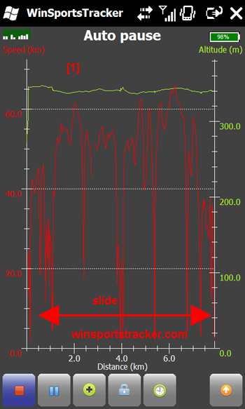
· Graphic display speed and altitude vs. distance, altitude display relative or absolute
· Track view on offline map (you do not need data plan on your phone)
· Measuring units: metric, imperial, nautical
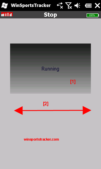
· Slide display, scroll list
· Power management long battery life
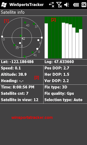
· GPS signal info (satellites, signal strength)
· Auto save track in case if battery runs out
· History of tracks
· Export track in GPX format (you can view track in Google Maps or some different app.)
· Translations
· Normal/full screen mode
· Supported resolutions: WVGA, VGA, square, WQVGA, QVGA, portrait and landscape orientations

What's New in This Release:

· Altitude display on map view
· Minimum battery settings

What's New in 3.17

· Greek translation
 
Like it? Share with your friends!

If you got an error while installing Themes, Software or Games, please, read FAQ.
 

Supported operating systems: Windows Mobile 6.5 Professional
 
Similar Software:

Map4Fun Taipei-GPSMap4Fun Taipei-GPS
Map4Fun Taipei-GPS - Going to Taipei? just download it for free! Attractions and shops/hotels/restaurants... in Taipei... find coupons/POI instant video/communication links...on hand, and much more of major Asian cities at Map4fun. 1. Taipei Information. 2. Useful numbers. 3. Tourist attraction. 4. East Taipei area map. 5. Jhonshan area map. 6. Sinyi area map
SportsGPSesSportsGPSes
SportsGPSes - SportsGPSes can be used to view all of the players using the PocketPC SportsGPSer. The program downloads the GPS of all players and displays them on a customized map from Google.com. This program requires that you have both the 'BeanDLL.dll' file ** and ** the runtime files for Visual Basic on your PocketPC computer
RulerGPSerRulerGPSer
RulerGPSer - RulerGPSer uses the GPS on your PocketPC to view and download GPS marked satellite camera pictures and calculates distance between two points specified by the latitude/longitude of your GPS using "The Vincenty inverse formula for ellipsoids." (accuracy to within 0.5mm, or 0.000015") This program requires that you have both the 'BeanDLL
gps2sms4poi66gps2sms4poi66
gps2sms4poi66 - Freeware application for poi66.com service. It sends periodically your GPS coordinates using SMS ("GP Lat Lon") for tracking via webpage on poi66.com. You can edit smsto.txt which holds phone no's
RulerGPSedRulerGPSed
RulerGPSed - RulerGPSed uses the GPS on your PocketPC to calculate geodesic distance in 3 formats between two points specified by the latitude/longitude of your GPS using "The Vincenty inverse formula for ellipsoids" (accuracy to within 0.5mm, or 0.000015"). This program requires that you have both the 'BeanDLL
FON Access Points for MaltaFON Access Points for Malta
FON Access Points for Malta - FON offers you a new Points of Interest service (POIs). This allows you to download FONspots directly to your navigation device. What does that mean? You can download a Points of Interest file directly to your navigation device
TwitsnapsMapsTwitsnapsMaps
TwitsnapsMaps uses the GPS on your PocketPC to find your current latitude/longitude/speed and altitude and allows you to upload your position via map to Twitter.com. You can customize the maps zoom, and type via the 'Options' in the toolbar. The maps service is provided by Google.com. The map/Twitter storage is from TwitSnaps
FON Access Points for SingaporeFON Access Points for Singapore
FON Access Points for Singapore - FON offers you a new Points of Interest service (POIs). This allows you to download FONspots directly to your navigation device. What does that mean? You can download a Points of Interest file directly to your navigation device
e-Mobile GPS Trackere-Mobile GPS Tracker
e-Mobile GPS Tracker -   System Requirements Internet enabled Windows mobile Pocket PC with GPS. Requires WM5 and WM6 mobile devices
FileGPSesFileGPSes
FileGPSes - FileGPSes allows you to browse and execute the GPS tagged files and view them sorted in distance from your current GPS. You can also view and download the files placed on a Google.com map. This program uses "The Vincenty inverse formula for ellipsoids." (accuracy to within 0.5mm, or 0
 

Other Software by developer «WinSportsTracker»:

not found
 

Comments on WinSportsTracker:

Comments not found

Name:


Comment:


Enter text from image below:

Turn on images!


If you noted an error or download link is broken, please, report it via this page or use comments.
 

WinSportsTracker is compatible with your device RoverPC S8 Premium
 
 
© Pantich 2009 - 2025 All rights reserved.