Categories: Business & Profession, Travel & Navigation
Upload date: 18 Feb 12
Developer: Certified Tracking Solutions
License: Freeware
Downloads: 80
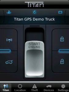
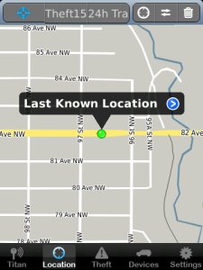
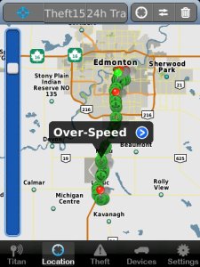
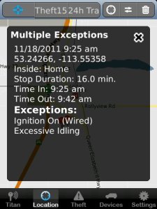
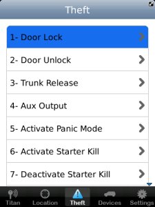
Titan GPS - Titan Tracking’s mapping dashboard interface is part of a “World Class” end to end GPS fleet management solution. The power behind Titan Tracking’s web based and mobile Smartphone dashboards is how they are cross compatible with the entire line of Titan’s industry leading GPS tracking hardware. Titan Tracking offers multiple series of hardware to connect to your App, ranging from Consumer Vehicle Connectivity to enterprise level Fleet Management. Below are just some of the GPS series offered by Titan and utilized with this Titan GPS mobile dashboard App. Consumer Vehicle Messaging & GPS Tracking: Use your Smartphone to start your remote car starter or to unlock your doors. Even instantly locate your vehicle via the Google Maps. Advanced Fleet Replay GPS Tracking: This series includes some of the most comprehensive fleet management product lines available on the market today and is perfect for fleet managers looking to see their fleet updating live on the map. See every turn, every stop, the location of idling and excessive speeding. DealerSecure™ Lease Series: The DealerSecure™ series by Titan is an excellent program for automotive dealers in need of tracking or even disabling a vehicle that is over due on their lease payments. Self Powered “SP” GPS Tracking Series: This truly remarkable series of hardware runs off of 4 AA “off the self batteries” and is excellent for remotely monitoring asset ranging from a boat or personal watercraft to a piece of construction equipment or even cargo containers.
Like it? Share with your friends!
Supported operating systems:
RIM BlackBerry OS 4.6, RIM BlackBerry OS 4.7, RIM BlackBerry OS 5.0, RIM BlackBerry OS 6.0
Similar Software:
Mobile GMaps Mobile GMaps is a FREE application that displays maps from various sources like Yahoo! Maps, Windows Live Local, Ask.com and Open Street Map on Java J2ME-enabled mobile phones, PDAs and other devices. MGMaps can connect to a GPS receiver over bluetooth or use internal GPS features on some phones in order to automatically display the map for your current position
GPS Coordinate Converter Now calculate coordinates in Deg Min Sec, GPS Coordinates, Decimal Degrees with GPS Coordinate Converter app.A simple app that lets you convert between different coordinates. This is an essential tool for fieldwork when you're using maps and charts
C3 Hybrid C3 Hybrid - C/3 Hybrid is a Telematics module that allows you to have Keyless Entry, Security, Remote Start and GPS tracking control on your Smart phone via the C3 phone application. The Free C3 application offers easy to use and navigate touch controls with sound effects when button feature activated
FON Access Points for Morocco FON Access Points for Morocco - FON offers you a new Points of Interest service (POIs). This allows you to download FONspots directly to your navigation device.
What does that mean? You can download a Points of Interest file directly to your navigation device
FON Access Points for Ireland FON Access Points for Ireland - FON offers you a new Points of Interest service (POIs). This allows you to download FONspots directly to your navigation device.
What does that mean? You can download a Points of Interest file directly to your navigation device
FON Access Points for Monaco FON Access Points for Monaco - FON offers you a new Points of Interest service (POIs). This allows you to download FONspots directly to your navigation device.
What does that mean? You can download a Points of Interest file directly to your navigation device
La Brújula La Brújula Cutty Sark is a geolocation app that will become your passport for the Cutty Sark Challenge. You will need a Facebook account in order to redeem your miles, and authorize the app to use your name
GPSTool GPSTool- displays basic GPS information such as location, altitude, speed, and heading. GPS Tool also uses OS 5.0 to show the number of satellites, the signal strength and location of each satellite in a pseudo polar coordinate display
FON Access Points for Brazil FON Access Points for Brazil - FON offers you a new Points of Interest service (POIs). This allows you to download FONspots directly to your navigation device.What does that mean? You can download a Points of Interest file directly to your navigation device
Other Software by developer «Certified Tracking Solutions»:
AutoConnect GPS AutoConnect GPS - Powered by Certified Tracking Solutions AutoConnect’s mapping dashboard interface is part of a “World Class” end to end GPS fleet management solution


")

