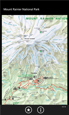
Mount Rainier National Park - Shows your location on the national park map. This app does not require a cellular or wireless connectivity, so it works in areas that don't have any network. It displays a map of the national park, with your GPS location on it.
Like it? Share with your friends!
If you got an error while installing Themes, Software or Games, please, read FAQ.
Supported operating systems:
Windows 10 Mobile, Windows Phone 7, Windows Phone 8
Similar Software:
I'm here! I'm here! - This app allows you to send your current location by mail easily.
I want you to use this app when you lost your way...
Application requires GPS in order to make e-mail body automatically. We don't store your location data
YourGPSPosition YourGPSPosition - This simple app will check your position and show your coordinates and your position on a Bing map.
Disclaimer:
This application is for entertainment purposes only and not intended for use as any means of navigation.
The developer of YourGPSPosition is not responsible for any damages as a result of the use of YourGPSPosition by you or a third party
Legoland California Find your way at Legoland California. This app shows your current location on the attractions map
Find My Car Find My Car - Did you ever park your car and not remember where it was parked? It can be hard to find your car again in this situation. With this application it allows navigate from your current location to your car. It is also possible to store the parking ticket expiry time with a countdown
SmartRunner SmartRunner is the sports tracking application for your Windows Phone Device, which allows you to record your next run, biking trip, hike, walk, ride, or any other outdoor activity and publish them on www.smartrunner.com. The application informs you in real time about your average and maximum speed, distance and calories burnt. Sign up for a free webaccount at www
GPS-Data-App This app shows the latitude and the longitude of your GPS
GPSInfo GPSInfo is a simple tool for displaying all the data from your Windows Phone 7 GPS receiver. It allows you to see: actual coordinates (Latitude and Longtitude), GPS date and time, speed, current course (relative to North), horizontal and vertical accuracy
MyDistances MyDistances - Die App ermoglicht es, die Koordinaten mehrerer Orte zu speichern und die Entfernungen zum aktuellen Standpunkt zu berechnen. Auch Entfernungen von einem der Orte zu allen anderen gespeicherten Orten lassen sich schnell ermitteln. Alle Orte konnen schnell und einfach auf der Karte angezeigt werden
GPS Distance GPS Distance - GPS Distance vous permet de calculer rapidement et facilement la distance i vol d'aoiseau qu'il y a entre deux coordonnees GPS.
Les coordonnees sont donnees de facon decimales representant la valeur de l'angle en degre et le resultat est donnee en kilometre
My Footprints My Footprints helps you save your current location information so that you can reference the information later or share the information with friends
Other Software by developer «EduTocuh»:
Legoland California Live Map Legoland California Live Map - Find your way at Legoland California. This app shows your current location on the attractions map.
Note: this app is unofficial - it is not affiliated with Legoland
Legoland California Find your way at Legoland California. This app shows your current location on the attractions map