Geo32 for Windows Phone 7 is a GPS coordinate in a format that is easy to read, remember and transmit. Transmitting or receiving locations has never been simpler.
The Windows 7 Phone Geo32 application will translate the GPS of your position (or anyone else's) into Geo32 code.
The problem: You arrange a meeting with a friend in town. The friend comes to town but he's late and you have moved on. He can't find you despite the directions you give. You start by asking him to describe where he is, but you can't tell where they are.
The solution: You decide to ask for his Geo32 code. He launches the application and gets a code in seconds and sends it to you by sms. You enter the code in the Geo32 application and you immediately get the position. You can go to meet him or give him your own code so he can come to you.
Geo32 code is easy to remember and us. GPS coordinates are difficult to remember and coding errors are common. In some countries, the Geo32 code is sometimes no more than 4 letters!
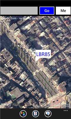
The geographic position (latitude and longitude) is rounded to 3 decimal places. The result is encoded on 78 bits for the absolute value and a variable number of bits for the relative value (the country). These values are then converted into string based on 32 letters and numbers.
Like it? Share with your friends!
If you got an error while installing Themes, Software or Games, please, read FAQ.
Supported operating systems:
Windows 10 Mobile, Windows Phone 7, Windows Phone 8
Similar Software:
RunBuddy-Free RunBuddy was started as a project to help me train for a half marathon using my new phone. I wanted a simple GPS Running application where I can review the different miles in my run and past runs to see how my training is progressing. RunBuddy will help you find where during a run your pace slows and how you are improving over time
GPS Tracker Lite GPS Tracker Lite is an application that tracks your route while you move (walk, run, drive) and shows two main things: statistics of the route, and a map
Geotagged List Geotagged List allows you to "tag" your current location and add photo, a short description, and position. You can keep a list of these items so you can navigate your way back to these places. The
Reach That Point Reach That Point - With this application you can navigate from your current location to one of your favourite locations by following the on-screen compass information
Dabble Locate Dabble Locate automatically creates and sends a Text or Email Message that contains a link to a map with your current location. This useful message allows your friends and family to open a map and see exactly where you are on the map. No more trying to explain that you are near the large green sign and the tall pine tree over by the north entrance of the west trail
JaefreyGPS Lite JaefreyGPS Lite This application enables you to view your current position and course. Furthermore you can record a track while walking or driving and upload this track as kml-file to your Dropbox account
Destinations Destinations - This is a great way to keep track of the locations of several places and then recall them easily.
Simply add an address or a place name to the list and Destinations will place a pushpin on the map at the location.
Click on an item in the list to see a zoomed in map view that centers on the Destination you have chosen
NOAA Buoy NOAA Buoy - The National Oceanic and Atmospheric Administration keeps a database of information retrieved from smart buoys. This app retrieves the data from the buoys surrounding your current location. You can also change your location to look for other buoys
Mobile Speedo Mobile Speedo - Mobile Speedo uses your mobile phone's GPS to accurately display your current location, direction and speed. You can also record, share and review this information.
Features:-
Display current speed, average speed, distance travelled, top speed and compass heading
Velo en ville Localisation et disponibilite des velos en location dans differentes villes (Paris, Toulouse, Marseille).
Possibilite de gerer des favoris
Other Software by developer «Active Up»:
Wallonie Traffic Wallonie Traffic vous permet d'afficher l'image de dizaines de cameras d'autoroutes wallones. Elles sont rafraichies toutes les 10 minutes environ