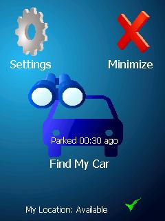
ppc FindMyCar - Innovative software for Windows Mobile devices that uses the GPS signal to show signs that allow to reach a geographic location.
Suitable for various uses (eg. find car parked in a parking area or in an unknown city, finding a person (who has sent their coordinates) in a lovely beach, in a fair, in another boat, find an area of sea fishing, etc..).
· store position and then retrieved at a later date
· forward our position with sms
· set the position transmitted (eg. the person we are looking for) with the copy-paste function
· displayed on the map (via internet GoogleMap) location to be searched
Like it? Share with your friends!
If you got an error while installing Themes, Software or Games, please, read FAQ.
Supported operating systems:
Windows Mobile 2003, Windows Mobile 5.0, Windows Mobile 6 Classic, Windows Mobile 6 Professional, Windows Mobile 6.1 Classic, Windows Mobile 6.1 Professional, Windows Mobile 6.5 Professional
Similar Software:
GPSLocaterer GPSLocaterer uses the GPS on your PocketPC to find your current latitude/longitude/speed and altitude and allows you to view your position on a map from the Google.com maps service. You can customize the maps zoom, and type via the 'Options' in the toolbar
FON Access Points for Palau FON Access Points for Palau - FON offers you a new Points of Interest service (POIs). This allows you to download FONspots directly to your navigation device.
What does that mean? You can download a Points of Interest file directly to your navigation device
FON Access Points for Gabon FON Access Points for Gabon - FON offers you a new Points of Interest service (POIs). This allows you to download FONspots directly to your navigation device.
What does that mean? You can download a Points of Interest file directly to your navigation device
FON Access Points for Panama FON Access Points for Panama - FON offers you a new Points of Interest service (POIs). This allows you to download FONspots directly to your navigation device.
What does that mean? You can download a Points of Interest file directly to your navigation device
GPS.PI This program exchanges geographical position points by SMS or Email (GPRS, Bt, Wifi) services of cellular phone network.
This version works with any Pocket PC Phone Edition devices.
MS Smartphone version is available too
FON Access Points for Liechtenstein FON Access Points for Liechtenstein - FON offers you a new Points of Interest service (POIs). This allows you to download FONspots directly to your navigation device.
What does that mean? You can download a Points of Interest file directly to your navigation device
Virtual Earth Mobile Virtual Earth Mobile (VEM) is an application that displays maps and satellite photography
amAze (Samsung) AmAze is a first of its kind free navigation and local search service. It is free to download and use and it contains wide coverage of maps including aerial photo in Europe, North America, Australia and parts of Asia and Africa
chtiGPS chtiGPS is intended to the sportsmen and to hikers, for their training (bicycle, rollers, ski...), but also to locate itself by knowing the distance and the direction from the closest cities. Geolocalization finally makes it possible to reassure its close relations at the time of great exits..
ppc Phonetic Alphabet ppc Phonetic Alphabet - Tool for getting the phonetic spelling of words. You write a word and you get a list of characters according to the NATO phonetic alphabet. You can also create and observe the translation of the single Morse character
ppc PhotoGeoTag ppc PhotoGeoTag - Take pictures with your mobile phone and incorporate the data of the geographical location. The application allows you to include in the photographs, data from the GPS receiver, along with a brief note. If you know the coordinates, not having the GPS receiver, you can also handwrite geographic data
j2me PhotoGeoTag j2me PhotoGeoTag - Take pictures with your mobile phone and incorporate the data of the geographical location. The application allows you to include in the photographs, data from the GPS receiver, along with a brief note. If you know the coordinates, not having the GPS receiver, you can also handwrite geographic data
PhoneAlcolTest Calculate blood alcohol based on the tables attached to the DM 30/07/2008 THE MINISTRY OF LABOR, HEALTH AND SOCIAL POLICY bearing: "Urgent changes in the code of the street to increase safety levels in the circulation
Android Photo GeoTag Android Photo GeoTag - Take pictures with your mobile phone and incorporate the data of the geographical location. The application allows you to include in the photographs, data from the GPS receiver, along with a brief note. If you know the coordinates, not having the GPS receiver, you can also handwrite geographic data
Android FindMyCar Android FindMyCar - Innovative software for Android devices that uses the GPS signal to show signs that allow to reach a geographic location.
Suitable for various uses (eg. find car parked in a parking area or in an unknown city, finding a person (who has sent their coordinates) in a lovely beach, in a fair, in another boat, find an area of sea fishing, etc..)


")


