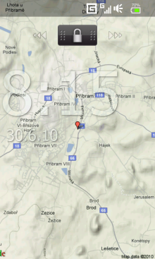
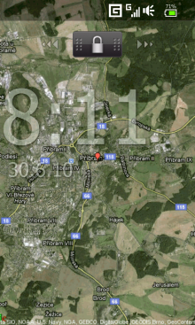
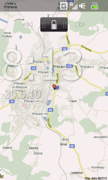
WMM Wallpaper Map locates the coordinates without the use of GPS (like Google Maps), downloads the map from GoogleMaps and sets it as background.
· Supports Today, Sense / TouchFlo, Co0kie's home
· Can change the map zoom and map type (4)
· You can view location marker
· Supported resolutions: SQVGA, QVGA, QVGA L, VGA, WVGA.
What's New in This Release:
· Support S2U2
· Skip update if is No Service
Like it? Share with your friends!
If you got an error while installing Themes, Software or Games, please, read FAQ.
Supported operating systems:
Windows Mobile 6 Classic, Windows Mobile 6 Professional, Windows Mobile 6.1 Classic, Windows Mobile 6.1 Professional, Windows Mobile 6.5 Professional
Similar Software:
Tube New York Pro (2009 Edition) Tube New York Pro
New release with GPS support & Live travel information.
This superb map package for Tube is the ideal map for anyone who needs to get around New York City using the MTA subway system and would like to know just exactly where they are
PrettyEarth PrettyEarth
View maps of Earth with PrettyEarth! See current day and night regions, learn geography by taking the quiz, enjoy relief elevation surfaces and measure distances between locations
VITO AstroNavigator II AstroNavigator takes all the beauty of the night sky and puts it right on the screen of your device
Rough Guides Map Paris Rough Guides Map Paris... These guides are a series of fantastic interactive maps.
Produced in conjunction with the premier travel publisher Rough Guides.
Discover and explore Paris using full colour interactive linked maps, in this simple to use PDA version of The Rough Guides Paris
J2ME OGC WMS Client J2ME OGC WMS Client is a program for accessing OGC Web map services from Java enabled mobile phone or PDAs.
It accesses the OGC WMS according to WMS 1.1.0 and 1.1.1 specifications and supports zooming and panning in the Map, WMS sublayers, and a bookmark management system for quick access.
Free for non-commercial use
Free Earth Elevation Map for PrettyMap/PrettyEarth Earth Elevation Map for PrettyMap/PrettyEarth - This is a medium-resolution, free Earth elevation map for PrettyMap and PrettyEarth. It contains one elevation sample per 4 km, approximately.
Note: large file (16 MB download, 55 MB after installing).
Note for PrettyEarth users: this map will be installed to Program FilesPrettyMapmaps
DeliveriesRouting DeliveriesRouting - This program allows you to enter two addresses and uses the Microsoft Live service to route a map for you. Line 1 = address and street, Line 2 = is the city/(state/province). To use the same city keep line 2 clear.
This program requires that you have both the 'BeanDLL.dll' file ** and ** the runtime files for Visual Basic on your PocketPC computer
TravelMaper TravelMaper - TravelMaper is a database of 661 major cities worldwide with Latitude/Longitude coordinates for each and direct Google.com map view/download. Select the city and select "view" or "download" map to download the Google.com Map. You can also customize the type of view and zoom via the options settings
MobileMaps MobileMaps - This program connects you to pda.maporama.com, an online map service. NOTE: You must be connected to the internet to use this program.
This program requires that you have both the 'BeanDLL.dll' file ** and ** the runtime files for Visual Basic on your PocketPC computer
GSz GSz is an application that shows you around nice restaurants whenever you need.
· Search Restaurants by
· "Area/Station/Restaurant Name/GPS location".
· Restaurant information (Name/TEL/Address/Business Hours/Budget/etc...)
· GPS Monitor.
· Mobile GoogleMap
Other Software by developer «MikyWoW»:
WMM Wallpaper Changer WMM Wallpaper Changer - This program can automatically change the wallpaper based on time
WMM Lamp Simple flashlight application for Windows Mobile


")


