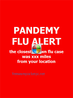
H1N1 Pandemy Flu Alert - This program recognizes your current location, from GPS Receiver, download the registered flu cases from the Internet database, and in case the closest flu was near your location, it will alert you by red screen and special sounds.
This program runs on every Windows Mobile phone.
The screen type and size is not a matter.
After the initial run, only 3 steps, it will download flu cases report automatically, and invisible for you. Only in case of alert you, it will display the red screen and play sounds. What you can be sure, and needn't check it manually every time.
Step 1:
Please read the initial descriptions. You can set the alert distance (radius) range. This is the radius around your own location, to alert you when (at least the one) recognized flu case was iside this circle.
Step 2:Set own location. You can write it manually, or you use GPS Receiver. Decide if you want to get own location every time please note: GPS Receiver consumes battery, and in some situation needs more time to get location. Alternatively, you can use the last known location.
Step 3:
Download report. It needs your phone to be connected to Internet. You can set downloading to run automatically. In this mode, it runs invisible, only in case of alert, it will display on the top of screen. You can test, how the alert will look.
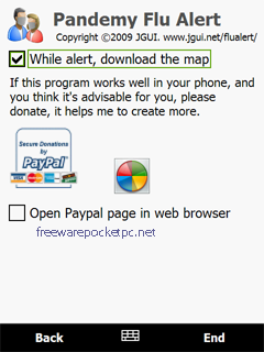
Additionally.
After the red screen, you can download the map to preview your location and the closest flu case.
Please note:
To disable the automatic downloading, you have to set the period in Step 3 to "never: manually". In this case, you download new flu cases report at your will.
Like it? Share with your friends!
If you got an error while installing Themes, Software or Games, please, read FAQ.
Supported operating systems:
Windows Mobile 5.0, Windows Mobile 6 Classic, Windows Mobile 6 Professional, Windows Mobile 6.1 Classic, Windows Mobile 6.1 Professional
Similar Software:
gpsVP gpsVP works on virtually any Windows platform including mobile ones. It shows vector and raster maps, records and shows tracks, shows multiple navigation parameters, manages and shows waypoints. It aims to be as usable as possible.
What's New in This Release:
· Geoid correction matrix: Updated values Atlantic & east America's
GPSMeter PDA GPSMeter PDA is program allows you to measure areas of any geometry, distances and to mark fixpoints
PMWGPSTracking PMWGPSTracking allows you to plot your trip in a file (. KML).
The trace files can then be viewed and compared with Google Earth.
For each track you can define intermediate time (time stamp).
For each lap, the program calculates the duration, average speed and distance.
The trace files can be sent at regular intervals on an FTP server or an email address
BackCountry Navigator BackCountry Navigator is fun-filled navigation software for the outdoor adventurer. Use it in a variety of outdoor adventures, from kayak touring to geocaching. This is a summary of what you can do with the product.
BackCountry uses free topo and aerial maps for the United States, downloaded directly from Terraserver-USA
MapGoogler MapGoogler uses the GPS on your PocketPC to find your current latitude/longitude/speed and altitude and allows you to view your position on a map from the Google.com maps service. You can customize the maps zoom, and type via the 'Options' in the toolbar. The maps service is provided by Google
TaxiGPSeds TaxiGPSeds - TaxiGPSeds can be used by a taxi driver that gets a GPS pickup. The program gets the current GPS and allows entry of the pickup GPS. Then you can view the distance and download the route map from the Google.com map service.
This program requires that you have both the 'BeanDLL.dll' file ** and ** the runtime files for Visual Basic on your PocketPC computer
FON Access Points for Guernsey FON Access Points for Guernsey - FON offers you a new Points of Interest service (POIs). This allows you to download FONspots directly to your navigation device.
What does that mean? You can download a Points of Interest file directly to your navigation device
FON Access Points for Denmark FON Access Points for Denmark - FON offers you a new Points of Interest service (POIs). This allows you to download FONspots directly to your navigation device.
What does that mean? You can download a Points of Interest file directly to your navigation device
FON Access Points for Lithuania FON Access Points for Lithuania - FON offers you a new Points of Interest service (POIs). This allows you to download FONspots directly to your navigation device.
What does that mean? You can download a Points of Interest file directly to your navigation device
FON Access Points for United Arab Emirates FON Access Points for United Arab Emirates - FON offers you a new Points of Interest service (POIs). This allows you to download FONspots directly to your navigation device.
What does that mean? You can download a Points of Interest file directly to your navigation device
Comments on H1N1 Pandemy Flu Alert:
Comments not found
If you noted an error or download link is broken, please, report it via this page or use comments.
H1N1 Pandemy Flu Alert is compatible with your device Pharos Traveler 127