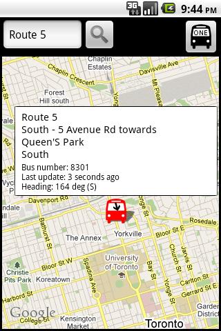
TorontoBusMap - TorontoBusMap shows locations and predicts bus times in Toronto using GPS info from the Toronto Transit Commission.
What's New in This Release:
· GPS now turns on when you start the app to allow quicker location lookup times. NOTE: There is also a new checkbox in the settings to disable this if you do not want it
· all stops mode added! This will show and update all bus stops around the center of the screen, not just ones on your current route. May be slow for older phones
· recently updated stops are temporarily colored green to show that they've updated
· search now searches stop titles in addition to routes
Like it? Share with your friends!
Supported operating systems:
Google Android 1.5, Google Android 1.6, Google Android 10.x, Google Android 2.0, Google Android 2.1, Google Android 2.2, Google Android 2.3, Google Android 3.0, Google Android 3.1, Google Android 3.2, Google Android 4.0, Google Android 4.1, Google Android 4.2, Google Android 4.3, Google Android 4.4, Google Android 5.x, Google Android 6.x, Google Android 7.x, Google Android 8.x, Google Android 9.x
Similar Software:
Tube Chaser Tube Chaser - Unofficial Android client for the London Underground and DLR, Open Sourced under GPLv3.
Real-time Tube status and departures, quick access to station info from favourites and find stations by GPS.
PLEASE NOTE: Some stations are missing from the list, or no useful information is given. This is ALWAYS due to TfL's poor data, not Tube Chaser
Tokyo Hotels Search Tokyo Hotels Search Book Cheap Tokyo Hotels. Save Up to 80% Tokyo City Hotels The world's largest hotel search engine that combines all hotel deals from the best travel sites into one free, quick and easy search. Genius!
Washington Metro This app grants you fast acces to the last Washington map, no internet connection needed once it has been installed. Full zoom controls. Fast, light and simple
Camping Get Camping app and find out everything about camping! Watch videos of experienced campers giving tips and demonstrating how to choose the right campsite, set up the camping equipment, and much more!
Find out everything about different types of camping: backpacking, canoe camping, sail camping, bic
AZ Menetrend - MAV Online MAV menetrend. Az elvira.hu adatait hasznalja, csak telefonra optimalizaltabb formaban. Hasznalatahoz internet kapcsolat szukseges. A telepuleslista nem teljes, ha valami neked hianyzik, ird meg emailben. *** AJVE! ****
Glob - TTS Plugin Don't waste your time. Be aware of road traffic and speed camera in real time ! This application is a plugin for Glob Traffic & Radar. This plugin allows you to use Speech Synthesis (TTS) for alerts on accidents and speed cameras
Istanbul Bus Istanbul Bus helps travelers to find the correct bus route in Istanbul. Enter your current place and target, Istanbul Bus will calculate the optimal route on the IETT bus lines. From and to fields offer suggestions while the user enters stop names
Stuff - Todo widget Stuff - is the best widget for list to do, which works from the home screen. Add tasks to the list with one tap to easily make a list to do. Moreover, the widget is placed on the screen in such a way that it is convenient for you to use your smartphone
TripIt - Travel Organizer TripIt Travel Organizer puts all your travel plans right on your Android! - Forward travel confirmation emails to plans@tripit.com to build a trip itinerary
Hong Kong Metro This application grants you fast acces to the last Hong Kong city metro map, no internet connection once the app has been installed. Zoom controls added for better control. Fast and simple
Other Software by developer «George Schneeloch»:
Los AngelBus Los AngelBus - This application shows locations and predicts bus times in Los Angeles using GPS info from the Los Angeles Metro.
What's New in This Release:
· GPS now turns on when you start the app to allow quicker location lookup times
UMichBusMap An Android application which shows the live positions of University of Michigan buses overlayed on Google Maps
BostonBusMap BostonBusMap is an application for Android phones. It uses GPS data provided by the MBTA to plot the real-time location of buses on a map.
What's New in This Release:
· GPS now turns on when you start the app to allow quicker location lookup times

")