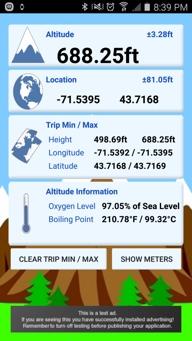
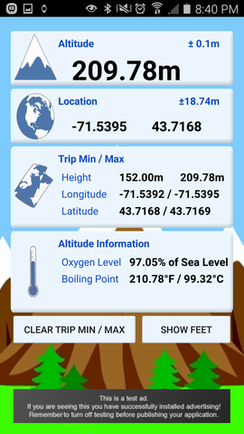
myAltitude - See your Altitude, and details of your trip, including Minimum and Maximum Altitudes, Oxygen levels and more! Full Android Wear support!
Includes improved & tested support for:
Moto 360
ASUS ZenWatch and
Samsung Gear
Like it? Share with your friends!
Supported operating systems:
Google Android 10.x, Google Android 4.0, Google Android 4.1, Google Android 4.2, Google Android 4.3, Google Android 4.4, Google Android 5.x, Google Android 6.x, Google Android 7.x, Google Android 8.x, Google Android 9.x
Similar Software:
Kompas Kompas is a small pocket tool for compass navigation
Travel Compass In addition to basic compass function, also match a map fixed position, more easily provide the regions in all countries urgent telephone by the revolving of map to the purpose headway, ensure a self security
Talking Compass Talking Compass speaks your current heading and provides haptic feedback as your cross over any of the cardinal directions.
Touch the screen to hear your heading. Stroke the screen up/down to adjust verbosity
Compass XL Compass XL - Compass XL is a tool to search bearings (azimuth) using the device built-in magnetic sensors and the device GPS. You can also easy switch from true North and magnetic North. The compass accuracy depends on the performance of your device. If it works perfectly, this means your sensors are perfect, too
Compass Pro Navigator Compass Pro Navigator - This compass is a tool to search bearings(azimuth) using the built-in magnetic sensors. It has 4 significant features. 1. Although you may turn the phone into portrait or landscape mode, the heading is fixed. 2. The Camera's view is used for reality. 3. Metal Detector is included to verify the magnetic sensor. 4. GPS is supported
Android-Speedometer Android-Speedometer - Simple speedometer application and widget for Android.
Tip: on small screens hide timer or compass in settings.
Android-Speedometer features:
· numeric values for: speed (km/h, mph or kn), altitude (from GPS or webservice), cyclometer (km, mi, nm), timer, digital clock, compass, max
Smart Measure - rangefinder You can measure the distance and height of an object. Smart Measure Lite is the part 2. of Smart Tools series. (distance, height) This range-finder measures the Distance and the Height of an object by trigonometry
GeoLog GeoLog saves the sensors data (gps, accelerometer, magnetometer data, etc.) of your device to a log file and calculates the coverage of the site. The coverage is a ratio of the track covering area to the area of the site (expressed in percents)
Other Software by developer «Rovingsquid»:
not found
Comments on myAltitude:
Comments not found
If you noted an error or download link is broken, please, report it via this page or use comments.
myAltitude is compatible with your device Oppo N1 / N1T


")


