NAVIGON Europe for Android - NAVIGON turns your mobile device into a fully featured GPS navigation system. The software provides advanced functionality for both drivers and pedestrians, including 2D and 3D maps, route planner, speed assistant, voice directions, local search, and more.
NAVIGON uses offline maps, so you don't need to worry about data traffic or roaming charges. After installation, you will need to download map data once and then you will be able to use the app without an internet connection. NAVIGON Europe for Android features:
· Google Street View destination preview
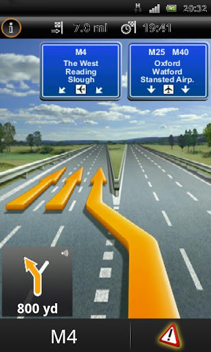
· Lane assistant
· Bluetooth support
· Google Local Search
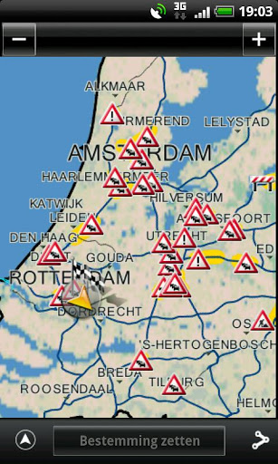
· Safety Cameras
· Reality View Pro
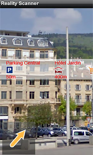
· NAVIGON Reality Scanner
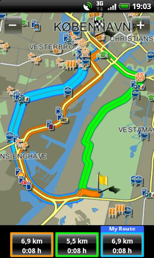
· NAVIGON MyRoutes
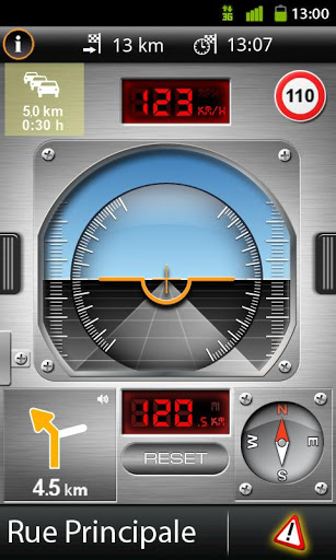
· Text-to-Speech and precise spoken announcements
· Destination entry with coordinates
· NAVTEQ map data for 44 countries of Europe
What's New in This Release:
· Mobile Alert Live - A new service for real time reporting and receiving locations of speed cameras. It is now also possible to confirm displayed cameras
· Traffic events on route can be read by a TTS voice
· EULA and privacy statement
· Bug fix
What's New in 4.8.0:
· New graphic support for Full HD devices (Galaxy S4, HTC one etc.)
· General graphic improvements for all devices (sharper images, zoom level)
· List of Glympse recipient shows now who watched the Glympse
· EnergySaver enhanced for general map drawing
· Bug fix (Zoom, map drawing after phone call)
What's New in 4.7.1:
· An additional EnergySaver setting - "Reduced frame rate when no instruction is available" - has been added. This function is the new default for EnergySaver
· Bug fix: Default setting for "Use GPS when app is in background" is set to "off" again
· Bug fix: GPS turned on automatically after app was closed
What's New in 4.7.0:
· Foursquare: Search for recommended locations from the Foursquare community and check in at your arrival
· Glympse: Send your current location during a pre-defined time to selected contacts via SMS or mail. The Receiver only needs a web browser to see where you are
· Wikipedia locations: The locations mentioned in the Wikipedia mobile database have been added as a new POI category. You may also read the related articles
What's New in 4.6.2:
· Bug fixes
Like it? Share with your friends!
Supported operating systems:
Google Android 10.x, Google Android 2.2, Google Android 2.3, Google Android 3.0, Google Android 3.1, Google Android 3.2, Google Android 4.0, Google Android 4.1, Google Android 4.2, Google Android 4.3, Google Android 4.4, Google Android 5.x, Google Android 6.x, Google Android 7.x, Google Android 8.x, Google Android 9.x
Similar Software:
My place My place This application allows you to determine your current location and to share it with your friends by sms or e-mail, if you want or need this.
Also it is possible to share your location with other apps, which are already installed on your phone (Google maps, Twitter apps, notes, etc.)
NAVIGON Australia for Android NAVIGON Australia for Android - NAVIGON turns your mobile device into a fully featured GPS navigation system. The software provides advanced functionality for both drivers and pedestrians, including 2D and 3D maps, route planner, speed assistant, voice directions, local search, and more
GoPenS GoPenS is an OpenSource GPS application for Android phones, based on OpenStreetMap (OSM). OpenStreetMap is a collaborative map of the world. Therefore, one of the main functions of the application is to be able to record a trace and send it as a GPX to the OSM servers, and so edit the OSM Map
Radardroid Lite GPS speed camera warning application for Android devices. Radardroid will give a visual and audible warning when you approach any fixed or mobile speed camera in the application database. This application will give you advanced warning of possible danger ahead and will reduce possible speeding tickets thanks to the ever increasing available features
Quovady for Android Quovady is a service that allows you to ask your friends, your family or coworkers "where are you?", let them know of your whereabouts or track their location if they gave you permission to do so
TomTom South East Asia for Android TomTom South East Asia for Android - TomTom South East Asia is a turn-by-turn GPS navigator for Android devices. The app includes accurate offline maps, so you can find your way anywhere, even without an internet connection
MapMyHike+ for Android MapMyHike+ for Android - MapMyHike is a mobile assistant designed to allow hikers to track their activities using their phone's built-in GPS.
With the app you can view your route on a map and record your trip details, including duration, distance, pace, speed and elevation.
You can also share the details of your activity with friends via Facebook, Twitter or email
BeOnMyMap (Android) BeOnMyMap The Android mobile device application for the BeOnMyMap.Com service. BeOnMyMap is a location based socialisation application, consisting of the BeOnMyMap.com website, a mobile website for use on your mobile phone (BeOnMyMap.mobi) and integrated applications for mobile devices
Fleet Activity Logger Fleet Activity Logger - Why do you need Fleet Activity Logger application?
- Track your fleet to increase your productivity
- View entire fleet on a single map screen
How to start?
1. Install the application on your Android phone.
2. Create your account by providing your email id, phone number of the device, name, country and submit it.
3
Other Software by developer «NAVIGON»:
NAVIGON U.S. West for iPhone/iPad 2. With NAVIGON MyRegion you can transform your iPhone into a fully functional mobile navigation system that is every bit as good as the multi-award-winning personal navigation devices from NAVIGON in terms of its user-friendliness and features
NAVIGON Eastern Europe for Android NAVIGON Eastern Europe for Android - NAVIGON turns your mobile device into a fully featured GPS navigation system. The software provides advanced functionality for both drivers and pedestrians, including 2D and 3D maps, route planner, speed assistant, voice directions, local search, and more
NAVIGON Australia for Android NAVIGON Australia for Android - NAVIGON turns your mobile device into a fully featured GPS navigation system. The software provides advanced functionality for both drivers and pedestrians, including 2D and 3D maps, route planner, speed assistant, voice directions, local search, and more
NAVIGON USA for Android NAVIGON USA for Android - NAVIGON turns your mobile device into a fully featured GPS navigation system. The software provides advanced functionality for both drivers and pedestrians, including 2D and 3D maps, route planner, speed assistant, voice directions, local search, and more.
NAVIGON uses offline maps, so you don't need to worry about data traffic or roaming charges
NAVIGON U.S. West for iPhone/iPad 2.7. NAVIGON U.S. West for iPhone/iPad 2.7. - NAVIGON U.S. West turns your iPhone or iPad into a fully featured GPS navigation system. The software provides advanced functionality for both drivers and pedestrians, including 2D and 3D maps, route planner, speed alerter, lane assistant, voice directions, local search, weather conditions and many others.
NAVIGON U.S
NAVIGON U.S. Central for iPhone/iPad 2. With NAVIGON MyRegion you can transform your iPhone into a fully functional mobile navigation system that is every bit as good as the multi-award-winning personal navigation devices from NAVIGON in terms of its user-friendliness and features
NAVIGON USA & Canada for Android NAVIGON USA & Canada for Android - NAVIGON turns your mobile device into a fully featured GPS navigation system. The software provides advanced functionality for both drivers and pedestrians, including 2D and 3D maps, route planner, speed assistant, voice directions, local search, and more
NAVIGON U.S. East for iPhone/iPad 2. With NAVIGON MyRegion you can transform your iPhone into a fully functional mobile navigation system that is every bit as good as the multi-award-winning personal navigation devices from NAVIGON in terms of its user-friendliness and features


")


