myLocation- It seems like websites and online services are popping up everywhere that can use location to give you more relevant information. Accuweather and others feature location aware weather sites and Google Maps can accept coordinate information to return location aware search results. Of course, with positional awareness comes controversy. Many emerging strategies are "push based" which means that your location is automatically (and perhaps secretly) pushed out to the Internet to maintain relevance. This project is an attempt to provide an alternative that gives you the benefits of location relevance while protecting your anonymity.
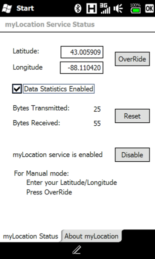
myLocation is a foundation service that simply stores position data, updated every 10 seconds, in the registry. This data is yours to use. You can choose how you want to leverage it.
The myLocation service stores your phone's current latitude and longitude in HKLM/Services/myLocation. Based on cell tower ID's, myLocation is accurate to within 1-3KM.
What's New in This Release:
· Obtained fix has GPS accuracy when Mach2003's GpsModDriver v2.2 or > is installed and active (a program is using the mod driver com port)
Like it? Share with your friends!
If you got an error while installing Themes, Software or Games, please, read FAQ.
Supported operating systems:
Windows Mobile 6 Classic, Windows Mobile 6 Professional, Windows Mobile 6.1 Classic, Windows Mobile 6.1 Professional
Similar Software:
Franson GpsGate Franson GpsGate -Share, simlulate and log the GPS
Share - GpsGate lets you share one GPS between several applications. GpsGate can create any number of virtual serial ports which most NMEA enabled GPS applications can connect to
ExcelGPSs ExcelGPSs - ExcelGPSs can be used to make Excel sheets with a GPS tag as the sheet file name. Each time you make a sheet the sheet is named the latitude and longitude of the file. You can store your files on the storage card. You can also view the Excels with Google maps.
This program requires that you have both the 'BeanDLL
FON Access Points for Maldives FON Access Points for Maldives - FON offers you a new Points of Interest service (POIs). This allows you to download FONspots directly to your navigation device.
What does that mean? You can download a Points of Interest file directly to your navigation device
gps2sms4poi66 gps2sms4poi66 - Freeware application for poi66.com service. It sends periodically your GPS coordinates using SMS ("GP Lat Lon") for tracking via webpage on poi66.com. You can edit smsto.txt which holds phone no's
Gpx2bin Gpx2bin - Gpx2bin is a GPS track converter software for Windows Mobile.
It can be used to convert .gpx, .mps, .plt and .nmea formats to the tracks.bin file used by Navitel Navigator to see the track as "blue line."
What's New in This Release:
· A problem with large files opening was fixed
LiteTrack LiteTrack is the right tool to record your route, save off-road paths, retrace a way, get your position on the map with detailed gps data (satellite charts, speed and much more)
Xylon GPS Data Logging for the Pocket PC Xylon GPS Data Logging for the Pocket PC - Xylon captures and stores GPS information as required and configured by you. This is true low cost flexible data acquisition, the only requirements being a Pocket PC and GPS capture module. Depending upon your requirements you can use anything from a $60 GPS board to a real time kinetic system
GPS Mod Driver GPS Mod Driver - This Driver installs between your GPS application and the GPSID driver that reads the hardware GPS data. Lag is compensated, by guessing your position 'some number' of milliseconds in the future, current course and speed changes are included in the guess
NavIt NavIt is a car navigation system with routing engine.
It's modular design is capable of using vector maps of various formats for routing and rendering of the displayed map. It's even possible to use multiple maps at a time.
Modular, touch screen friendly car navigation system with GPS tracking, realtime routing engine and support for various vector map formats
TravelPicturer TravelPicturer - TravelPicturer uses the GPS on your PocketPC to graphically view your GPS movement. You can adjust the slider for to view larger distances on the map. This uses "The Vincenty inverse formula for ellipsoids." (accuracy to within 0.5mm, or 0.000015")
This program requires that you have both the 'BeanDLL
Other Software by developer «Sleuth255»:
SIPChange SIPChange - SIPChange is for those who can no longer change their defaultIM using the reghacks after upgrading to AKU2.x. No matter what you choose, the keyboard SIP is always selected after a soft reset.
If you aren't having this problem, then you don't need this little app
PTTFix PTTFix - this little application replaces the Cingular PTT service and adds customizable launch capabilities back to that useless PTT button on your Cingular ROM equipped Hermes. This patch initially maps the PTT button to the built in Voice Dialer, but you can re-map the push as well as the hold functions to the application of your choice
myRadar myRadar is a location aware radar application that makes use of Wunderground and Accuweather US web services to show real-time, animated Radar Images of your local area regardless of where in the US you might be. This application requires myLocation services to function automatically.
The program will install to /Program Files/myRadar
mySearch mySearch is a location-aware search application that uses Microsoft Bing to return results based on your current position. Just enter in your search term and press the search button to return location specific results!
If your device has HTC's G-Sensor service then simply orient the screen for landscape or portrait mode
ATI ImageON Fix ATI ImageON Fix - This application fixes the ATI ImageON acceleration bug. This is the bug that causes the screen to "tear" during accelerated video playback using CorePlayer, TCPMP or other players that take advantage of the ImageON hardware acceleration. Once this bug is occurring, the entire screen is unreadable until you somehow exit from the video player