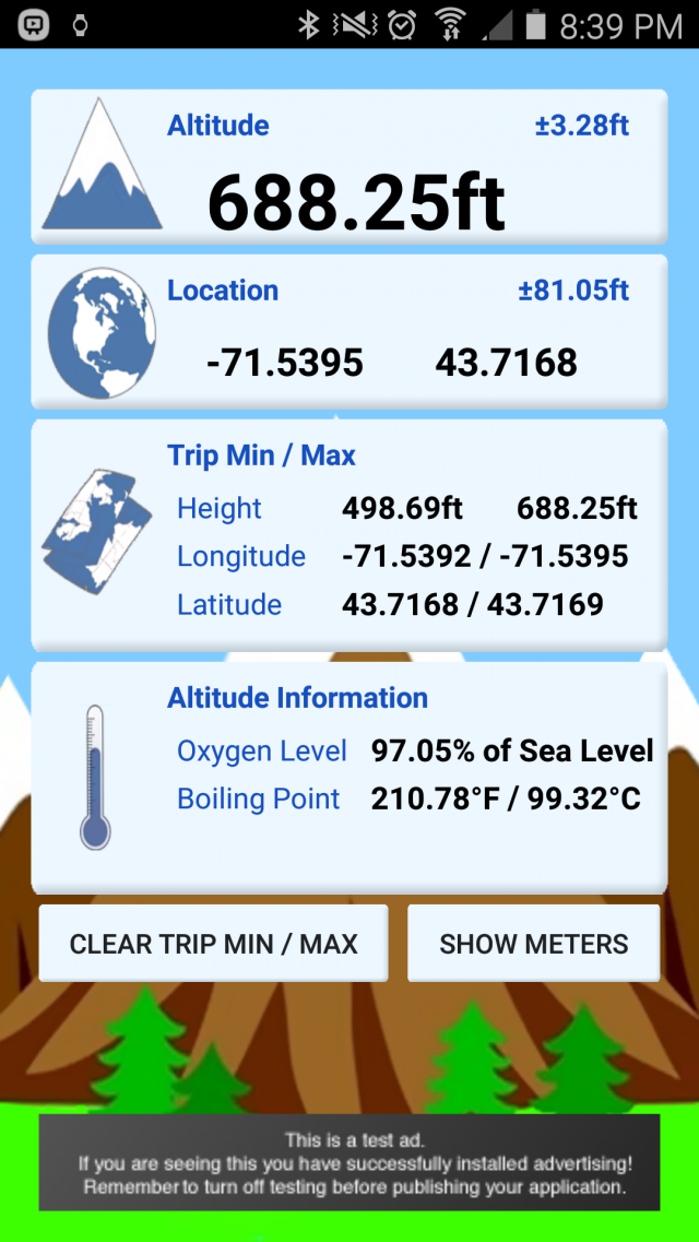
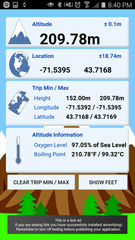
myAltitude - See your Altitude, and details of your trip, including Minimum and Maximum Altitudes, Oxygen levels and more! Full Android Wear support!
Includes improved & tested support for:
Moto 360
ASUS ZenWatch and
Samsung Gear
Like it? Share with your friends!
Supported operating systems:
Google Android 10.x, Google Android 4.0, Google Android 4.1, Google Android 4.2, Google Android 4.3, Google Android 4.4, Google Android 5.x, Google Android 6.x, Google Android 7.x, Google Android 8.x, Google Android 9.x
Similar Software:
Distance Measurement Distance Measurement - Quick distance calculator, measurement or estimator using:- 1. Screen (for small object) 2. Camera (for short distance) 3. GPS/Network (for long distance) ~~~~~~~~~~~~~~~~~~~~~~~~~~~~~~ A) How to measure using Screen:- 1. Put the object on your phone's screen 2. Drag the button to start measurement B) How to measure distance using Camera:- 1
GPSTest GPSTest - Program to show off the GPS capabilities of your Android device. Displays Satellite positions and signal strengths as well as speed, bearing and altitude values. It includes a world map with the day/night terminator overlayed as well as your current location and the suns position
Compass Professional Compass Professional - Compass is easy to use; just use it like a real compass. Compass app is more than just showing degrees and north, south, east and west. I have designed Compass with user experience in mind, large numbers and easy to read design. Compass also allows you to set your directions by rotating the bezel for easier and professional navigation
CompassPro CompassPro - Best Compass application for Android! Two fantastic compass styles to choose from.
You can have a compass icon always showing on your phone screen! The size and display area can be easily configured.
Note: You need to Calibrate the Sensor Compass first: Rotating your phone around all axes in a continuous movement
Marine Compass Marine Compass - A simple marine compass: move your Android phone in all positions, and the compass will always stay parallel to the floor! Just for fun!
Note: Accuracy depends on the hardware, not on the software. This software only displays sensors values
Bubble Bubble- Over 2 million downloads! A bubble level. Hold any of the phone''s four sides against an object to test it for plumb/level, or lay it down on a flat surface for a 360° level
Super Smart Compass 2 Super Smart Compass 2 - Super Compass is a basic compass application that shows you which direction your phone is pointed. You can use Compass in all outdoor activities as you can think about - walking, sailing, hiking, climbing, camping, flying, reading a map and so much more. Super Smart Compass is a traveler's best friends
Super Swiss Army Knife Free Super Swiss Army Knife Free - This is a super software which has a multi-functional combination applying to life, travel and military combat. It is a veritable Swiss Army Knife with a cool widget desktop, including eight functions of ruler, protractor, flashlight, compass, gradienter, vertical, wall picture, telemeasurement
Naver Maps Naver Maps - Smarter than ever! Experience Naver Map for Android. You can find the shortest way to get to your destination, using public transportation even it is far away. You can also search the information on the area around you easily and check whether you are heading to your destination correctly with GPS and compass
Ruler (Android) A simple application to turn your Android phone into an emergency measuring device
Other Software by developer «Rovingsquid»:
not found
Comments on myAltitude:
Comments not found
If you noted an error or download link is broken, please, report it via this page or use comments.
myAltitude is compatible with your device NTT DoCoMo Sharp Aquos Zeta SH-01G


")