Athens Transportation - Information and tracking of buses, trolleys, tram, subway and trains lines/stops in Athens, Greece. English description at the end.
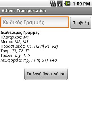
Η εφαρμογή περιέχει τις γραμμές και τις στάσεις όλων των μέσων αστικών συγκοινωνιών της Αθήνας (λεωφορεία, τρόλεϊ, τραμ, μετρό, ηλεκτρικός και προαστιακός).
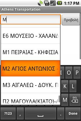
Δίνει την δυνατότητα στο χρήστη να επιλέξει τη γραμμή που επιθυμεί γράφοντας απευθείας τον κωδικό ή το όνομα της, είτε επιλέγοντάς την από τη λίστα βάσει του Δήμου που εξυπηρετεί.
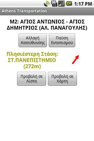
Στη συνέχεια μπορεί να δει ποια είναι η πιο κοντινή στάση στην τωρινή τοποθεσία του, με υπολογισμό της απόστασης από αυτή και ένδειξη της κατεύθυνσης, κάνοντας χρήση του ενσωματωμένου GPS και πυξίδας της συσκευής. (Απαιτεί να βρίσκεται σε απόσταση έως 1.5 χιλιόμετρο περίπου από την κοντινότερη στάση).
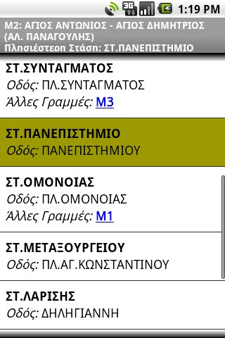
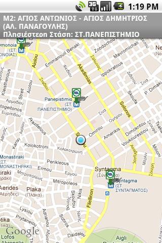
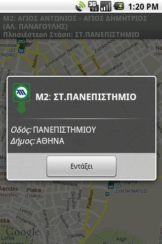
Οι στάσεις της επιλεγμένης γραμμής εμφανίζονται σε λίστα ή σε Χάρτη Google (απαιτεί σύνδεση στο Διαδίκτυο). Στη συνέχεια υπάρχει ενημέρωση σε πραγματικό χρόνο του ποια στάση βρίσκεται αυτή τη στιγμή και ποια είναι η επόμενη.
Επιπλέον Χαρακτηριστικά:
* Λειτουργεί χωρίς πρόσβαση στο Διαδίκτυο (εκτός των Χαρτών Google)
* Πολύ μικρό μέγεθος στη συσκευή, 200kb+, αν επιλεχτεί ως σημείο μεταφόρτωσης της βάσης η κάρτα μνήμης
Προσοχή:
* Η εφαρμογή περιέχει λάθη και παραλείψεις. Όταν συναντάτε κάποιο, επικοινωνήστε μαζί μου ώστε να το διορθώσω!
* Τα δεδομένα προέρχονται από την ιστοσελίδα του ΟΑΣΑ και περιέχουν επιπλέον διορθώσεις.
* Ο προγραμματιστής και η εφαρμογή ΔΕΝ έχουν καμία σχέση με τον ΟΑΣΑ.
* Ουδεμία ευθύνη φέρω για... αγνοούμενους στην Αθήνα :)
ENGLISH DESCRIPTION
The application contains the Lines and Stops off all public transports of Athens, Greece (busses, trolleys, tram, subway, electric railway and suburbian railway).
It lets user choose the Line they want, either by writing directly it's code or name, or selecting it from the list of municipalities it crosses.
Next they can see which is the closest stop to their current location, with calculation of distance and direction towards it, by using the embedded GPS and compass of the device. (It requires to be within a distance of about 1.5km (1 mile) from the closest stop).
The stops of the selected line can be displayed in a list or on Google Map (requires Internet connection). Then realtime information is displayed about which stop they are currently in and which stop comes next.
Additional Features:
* Works without Internet access (except for Google Maps)
* Very small installation footprint in device, 200kb+, if the External Storage is selected as the save point for the Database.
Note:
* The application contains errors and lacks information. When you come across any of them, contact me so I can fix them!
* The data originate from the website of OASA
http://www.oasa.gr
and contain additional fixes.
* The programmer and the application are NOT affiliated to OASA in any way.
* I can't be held liable for any... missing persons in Athens :)
Like it? Share with your friends!
Supported operating systems:
Google Android 1.5, Google Android 1.6, Google Android 2.0, Google Android 2.1, Google Android 2.2, Google Android 2.3, Google Android 3.0, Google Android 3.1
Similar Software:
T2D Charlotte NC T2D Charlotte NC - The quickest, easiest tool to search, share and save on all the best Charlotte, NC has to offer. Find family fun, sports and recreation, festivals, concerts, theater, nightlife, movies, getaways, the best casual and find dining restaurants and special events. Buy sports and concert tickets at discount rates
DB Navigator DB Navigator - Timetable and realtime information
With DB Navigator the Deutsche Bahn AG offers you the most comprehensive information service about public transport. The DB Navigator has access to all schedules of public transport operators in Germany and calculates the optimal trips for you by train, bus, tram, subway and ship
Madrid Metro|Bus|Cercanias Madrid Metro|Bus|Cercanias - Metro, Bus and Cercanias of Madrid in the palm of your hand!
Essential day to day application for locals, tourists, students, Erasmus, business visits ...
Features:
- | Metro de Madrid |
GPS Metro Station Finder.
Real time journey calculator.
Schematic and geographic network map including
Metro-SUR
Fares and Schedules
USA Hotels Search Want to go United States of America?
Looking for a hotel in this city or nice hotels at lowest rates?
Airport Info Lite Airport Info Lite provides realtime airport status information (for USA only currently), including closures and weather delays.
Includes a widget for home screen rotating info on problem airports, as well as application for detailed viewing of individual airports
Metroid Metroid is an Android itinerary planning application meant to help users with public transportation systems worldwide. Metroid has been designed with extensibility in mind. It is able to support any public transportation system provided that the right map is available.
Metroid is based on maps
Kayak Flight and Hotel Search Kayak Flight and Hotel Search - Travel search by Kayak. Find Hotel Rates, Cheap Flights and Airline Tickets on Kayak.com. Get Hotel Deals, Cheap Airfare and Book Cheap Tickets without Fees. Free Track Flight Status from flightstats. Free itinerary management, and calendar integration for trips. Google maps integration for hotels, airports, and trips
Other Software by developer «Kostas Tzounopoulos»:
not found
Comments on Athens Transportation:
Comments not found
If you noted an error or download link is broken, please, report it via this page or use comments.
Athens Transportation is compatible with your device NTT DoCoMo Samsung SC-05D Galaxy Note LTE