GPS Utility - GPS Utility helps you converts between all major geographical coordinate systems.
Helpful for excursionists, navigators users (TomTom, garmin, etc.), GeoCaching lovers, and Bing maps enthusiasts.
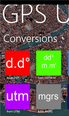
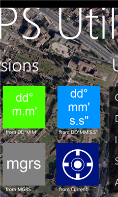
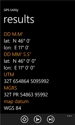
You can convert from and to:
- DMS coordinates (Degrees Minutes Second)
- DM coordinates (Degrees decimal Minutes)
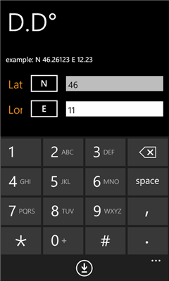
- DD coordinates (decimal Degrees)
- UTM coordinates (Universal Transverse Mercator)
- MGRS coordinates (Military Grid Reference System)
Plus:
- Get your local coordinate in all systems using internal Windows Phone GPS
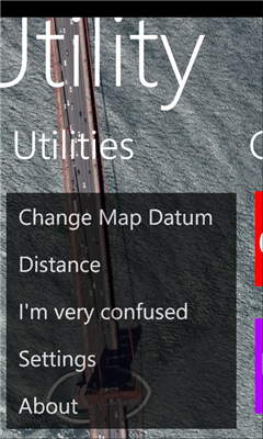
- Get the spherical distance between 2 coordinates
- Built-in Bing Maps view
- References (Wikipedia)
- Real time GPS coordinates
- Km and Miles supported
v1.1:
- add Wikipedia section
- automatic background changer
Like it? Share with your friends!
If you got an error while installing Themes, Software or Games, please, read FAQ.
Supported operating systems:
Windows 10 Mobile, Windows Phone 7, Windows Phone 8
Similar Software:
Compass Navigator Compass Navigator is designed to facilitate orientation in the field. The application is useful both in przepyadku lost the road, as well as during the Foot Orienteering.
Compass Navigator will guide you to your destination in a straight line (azimuth and compass). Purpose of the map you can select or enter the latitude and longitude coordinates
Driving Forces Driving Forces is a speedometer and G-Force meter: together at last! Mark your top speed and greatest Gs in 3 dimensions
Altitude Difference Collects the altidude difference of a hike in the mountains
Time To Go Time To Go - Time to Go is a simple tool to help you figure out how much time is remaining until you arrive at your destination. Simply put in your current speed and distance remaining (in MPH) and Time to Go will display your remaining time in hours, it's that simple!
Change Log
------------------------------------------------------------------
Version 1.1
Landmeter Landmeter - Call it inclinometer, call it clinometer, call it levels, call it whatever you like ... but you don't have enough of them ... There is still one missing ...
LandMeter is the official inclinometer for all off-roads enthusiasts, 4x4 cars, trucks, jeep, landrover, and trailers
SpeedChecker SpeedChecker - Displays your current speed, as well as providing graphs for recent speed, acelleration and height. You can also plot your recent drive on a map. Supports speed display as kilometers per hour and miles per hour
Simple Altimeter Free Simple Altimeter Free - This app answers one simple question: What's my elevation, according to the phone's GPS chip?
Have you ever been hiking, skiing, boarding, or even just driving and wondered what your approximate elevation is? This is the app for you. The best part is that it's free!
Disclaimer: This app is only as accurate as the GPS chip in your phone
Other Software by developer «Dimension Srl»:
Landmeter Landmeter - Call it inclinometer, call it clinometer, call it levels, call it whatever you like ... but you don't have enough of them ... There is still one missing ...
LandMeter is the official inclinometer for all off-roads enthusiasts, 4x4 cars, trucks, jeep, landrover, and trailers