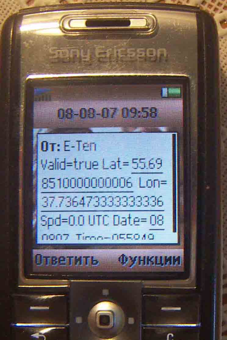
GPSbySMS (Java) - GPSbySMS reads data from the GPS receiver and sends it to the http://gps.ndd.ru site, or to other users using SMS messages. You can see your position on Yahoo Map. Auto send Mode available now.
Tested on: Sony Ericsson K6xx, K7xx, K8xx, W8xx series and Nokia 6151, 6288, 6300i.
Like it? Share with your friends!
Requirements:External Bluetooth or internal GPS receiver (NMEA GPS Message format) and Cellular phone with Bluetooth and Java;
MIDP 2.0 (JSR 118);
CLDC 1.0 (JSR 139);
Java API for Bluetooth (JSR 82);
Wireless Messaging API (JSR 120);
Phone Book Manager API (JSR-75);
Multi Media API (JSR-135)
Supported operating systems:
Java ME, Java Nokia 240x320, Java SE 240x320
Similar Software:
GpsMid Italy, South GpsMid Italy, South is a free, fully offline, vector based map application for your mobile phone. It displays your current position on a zoomable map and can be used to search for and navigate to roads or points of interest of your liking. As all data is stored in a compact binary format on your mobile phone you will incur no charges for extra data downloads
Tracking - Transportlines Tracking - Transportlines - Live GPS tracking system - Sign up at www.transportlines.com first to get your account - Free Allows for multiple users under your own account. Keeps, speed, direction, time, address of each reported position. Various reports available. Useful for hikers, cyclists, yachting, keeping track of your employees etc.
FON Access Points for Jamaica FON Access Points for Jamaica - FON offers you a new Points of Interest service (POIs). This allows you to download FONspots directly to your navigation device.
What does that mean? You can download a Points of Interest file directly to your navigation device
j2me PhotoGeoTag j2me PhotoGeoTag - Take pictures with your mobile phone and incorporate the data of the geographical location. The application allows you to include in the photographs, data from the GPS receiver, along with a brief note. If you know the coordinates, not having the GPS receiver, you can also handwrite geographic data
BT747 MTK GPS Datalogger Device Control BT747 MTK GPS Datalogger Device Control - i-Blue 747 / i-Blue 757 / Qstarz BT-Q1000 / i.Trek Z1 / Konet BGL-32 / Holux M-241 / ... control SW (for PalmOS, WinCe (PPC), Java platform, Windows, Linux, and MacOS). Compatible with most MTK GPS based loggers
GpsMid Lodz GpsMid is a free, fully offline, vector based map application for your mobile phone. It displays your current position on a zoomable map and can be used to search for and navigate to roads or points of interest of your liking. As all data is stored in a compact binary format on your mobile phone you will incur no charges for extra data downloads
Nulaz (LG) Nulaz is a simple application for mobile devices and the Internet that enables you to see each others' location:
Know where you are, where your friends are and send them messages for free!
With Nulaz, friends can find each other in a crowded place, a mother can keep an eye on her kids, and you can see where all your friends are when you go clubbing
FON Access Points for United Arab Emirates FON Access Points for United Arab Emirates - FON offers you a new Points of Interest service (POIs). This allows you to download FONspots directly to your navigation device.
What does that mean? You can download a Points of Interest file directly to your navigation device
TrackMyJourney (Sony Ericsson) TMJ-Mobile is a Java mobile phone application that uses GPS data to provide a number of functions, including navigation, location tracking, map display and route plotting. It receives its location coordinates by communicating via Bluetooth with a separate GPS receiver, or via the phones internal GPS if supported
Partner Tracker 2011 Partner Tracker 2011 - Take advantage of the latest Russian spy technology 2011 and use the top secret tracking system to locate anybody, anywhere at any time with your mobile at no additional costs! It only takes a few seconds to locate a mobile phone network
Other Software by developer «Astra-Service»:
GPSbySMS GPSbySMS is an application that reads navigation data from GPS and sends it to any user via SMS or email.
Purpose:
1) Read navigation data from GPS and send it to any user via SMS or email.
2) View current position on Maps (need Internet connection).
3) Save navigation data in database using data transfer via GPRS Internet
GPSbySMS (Android) GPSbySMS is an application that reads navigation data from GPS and sends it to any user via SMS or email.
Purpose:
1) Read navigation data from GPS and send it to any user via SMS or email.
2) View current position on Maps (need Internet connection).
3) Save navigation data in database using data transfer via GPRS Internet.
4) Alarm Function
GPSbyGPRS (Pocket PC) GPSbyGPRS is a version of GPSbySMS made for Pocket PCs without GSM module


")
")


")

")

")
")