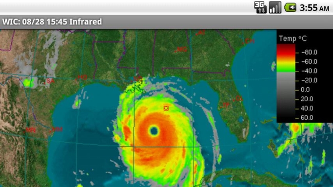
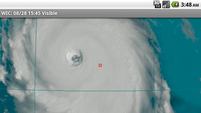
Where's It Cloudy is an Android application that shows real-time satellite data from the American Geostationary Weather Satellites. As a mobile phone application, you may access it to find out where it's cloudy in the vicinity of where you are located, or anywhere in the eastern and central United States and southern Canada. Most other weather apps do not show satellite imagery; they only show radar data. Radar data is effective at showing where there is rain and snow, but it doesn't show where clouds are located. Currently the App will NOT show imagery covering the West Coast.
The satellite data shown in Where's It Cloudy? is ideal for several purposes including:
· showing cloudy regions
· detecting the likelihood of precipitation
· helping track moderate to severe storms and hurricanes
· showing the movement, rotation, and structure of storms
· display of images in a time-lapsed loop.
Traditional weather applications show imagery covering only predefined areas at predefined resolutions. Where's It Cloudy? goes beyond this to allow the user to choose a default viewing point anywhere in North America, and a viewing altitude that determines the area the image will cover. A cloud computing platform renders the data based on your selections. The Cloud for Clouds!!
Once you set your default location and altitude, the image loops are dynamically generated at the maximum possible resolution from a 3D model of the Earth with the real time satellite imagery overlaid on this realistic model. This provides stunning and accurate visuals, especially in the Visible channel of satellite data.
Unlike other programs that may show the satellite imagery in a few shades at a reduced level of detail Where's it cloudy shows satellite imagery in full detail and in as many shades as are possible on your device. We also do not use lossy compression to preserve as much detail as possible.
If you select Tru-Sat Image it will show the raw satellite image as it was imaged from the satellite which in many cases can show much more detail. Give it a try you will be impressed.
What's New in This Release:
· Image Times are now in local time as determined by your devices time zone setting.
Like it? Share with your friends!
Supported operating systems:
Google Android 1.5, Google Android 1.6, Google Android 10.x, Google Android 2.0, Google Android 2.1, Google Android 2.2, Google Android 2.3, Google Android 3.0, Google Android 3.1, Google Android 3.2, Google Android 4.0, Google Android 4.1, Google Android 4.2, Google Android 4.3, Google Android 4.4, Google Android 5.x, Google Android 6.x, Google Android 7.x, Google Android 8.x, Google Android 9.x
Similar Software:
WeatherSignal WeatherSignal - The app makes use of native phone sensors to display local atmospheric readings, which are then displayed on our live-updating weather map. By using WeatherSignal you are becoming a part of the most ambitious weather crowdsourcing project in the world – helping to record weather patterns on a more localised level than ever before
TypoWeather Typographic Weather Widget for Android phones
14FirstAlert Weather TriState 14FirstAlert Weather TriState - Get the power of 14NEWS for Tri-State weather. Download our local weather app, 14 First Alert, right to your Android phone!
The local forecast, radar, and current weather conditions for Indiana, Kentucky and Illinois are all within this app, including Evansville, Henderson, Owensboro, Newburgh, Jasper, Madisonville, Princeton, Mt
Digital clock & world weather Clock & world weather widget with skins, dynamic (GPS) location and much more Digital clock & world weather widget A full featured, size 4x2 skinnable digital clock and weather forecast widget The widget features the following:
Snow and Ski Report by REI Snow and Ski Report by REI - Get the Snow & Ski Report by REI app for tracking your favorite snow spots.
The Snow & Ski Report by REI will help you figure out the best place to spend your time up at the mountain. Share conditions via the social net. Reference resort trail maps, view resort cams and stay in touch with participating mountain Twitter feeds
Hurricane Software Hurricane Software - Hurricane Tracking application to give you the most up to-date and reliable hurricane coordinates data and high resolution maps.
Satellite Images, Warning Information, Storm Tracks and More
WMD-Weather Lite WMD-Weather is a remake of the WMD-Weather Androkkid widget
wetter.com A weather station for your Android phone by wetter.com ! This app provides you with
Hava Durumu Surpriz hava sartlari planlarinizi alt ust etmesin! Hava durumu ogrenin zamaninizi daha guzel gecirin
Snowtam Decoder Snowtam Decoder - You have a snowtam in the metar report, you want to decode. Snowtam Decoder does it for you.
· Decoding of a snowtam in metar format
· Explanation of the items (A ,B , C, ..
Other Software by developer «Aquila Systems»:
not found
Comments on Where's It Cloudy:
Comments not found
If you noted an error or download link is broken, please, report it via this page or use comments.
Where's It Cloudy is compatible with your device Neo M1