- Save your track info,Record gpx file(it will be saved in "sdcard/DigitalDashboardGPS/gpx/")..
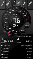
- Switch between car speedometer and bike cyclometer.
- Switch between mph or km/h mode.
- Display satellites status.
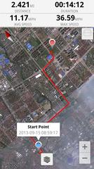
- Speed chart.
- Map integration,get your location.
……
Facebook:https://www.facebook.com/SpeedometerGPS
Like it? Share with your friends!
Supported operating systems:
Google Android 10.x, Google Android 2.2, Google Android 2.3, Google Android 3.0, Google Android 3.1, Google Android 3.2, Google Android 4.0, Google Android 4.1, Google Android 4.2, Google Android 4.3, Google Android 4.4, Google Android 5.x, Google Android 6.x, Google Android 7.x, Google Android 8.x, Google Android 9.x
Similar Software:
TomTom Mexico for Android TomTom Mexico for Android - TomTom Mexico is a turn-by-turn GPS navigator for Android devices. The app includes accurate offline maps, so you can find your way anywhere, even without an internet connection
amAze GPS light edition amAze GPS light edition provides access to worldwide street maps, full topographic map coverage of the USA and satellite imagery for 200 major cities around the world. It allows you to search in a worldwide rich POI database and you can upgrade to the full version that includes turn-by-turn voice guided navigation from within the application
Redpin The aim of the Redpin project is to create an open source system that allows indoor positioning up to room-level description using mobile phones
Waze Waze is a free, 100% user-generated, social navigation application that allows drivers to build and use live maps & real-time traffic updates to improve their daily commute
NAVIGON USA for Android NAVIGON USA for Android - NAVIGON turns your mobile device into a fully featured GPS navigation system. The software provides advanced functionality for both drivers and pedestrians, including 2D and 3D maps, route planner, speed assistant, voice directions, local search, and more.
NAVIGON uses offline maps, so you don't need to worry about data traffic or roaming charges
Satski Lite Satski Lite - The #1 ski/snowboard app. Real time ski navigation on 3D trail/piste maps. Imagine seeing your live GPS position, tracking & stats (speed, dist, alt). Use buddy tracking, get resort info, live weather, SOS
YGPS Satellites YGPS Satellites - YGPS Satellites is a small mobile application that allows you to easily assess the quality of your GPS signal. The utility displays the location of all the GPS satellites and shows the signal strength for every one of them.
Using the app is pretty straightforward
My Tracks My Tracks - Use My Tracks while you run, bike, hike, or do anything else outdoors, and it will use the GPS sensor in your Android phone to record the path you took. It will also gather useful statistics such as time, speed, distance, and elevation. You can review all of this data live, or you can save it for use later
amAze (Motorola) AmAze is a first of its kind free navigation and local search service. It is free to download and use and it contains wide coverage of maps including aerial photo in Europe, North America, Australia and parts of Asia and Africa
Speedometer GPS Speedometer GPS - Speedometer GPS can track your speed,distance,time,location and also can get start time,time elapased,avg speed,max speed,altitude...
Features included
- Save your track info,Record gpx file(it will be saved in "sdcard/SpeedometerGPS/gpx/")..
- Switch between car speedometer and bike cyclometer.
- Switch between mph or km/h mode
Speedometer GPS HD Speedometer GPS HD - Speedometer GPS HD can display more info on one screen.
Speedometer GPS HD can track your speed,distance,time,location and also can get start time,time elapased,avg speed,max speed,altitude...
Features included
- Save your track info,Record gpx file(it will be saved in "sdcard/SpeedometerGPSHD/gpx/")

")


")


