City Advisor is a Public Transport Navigation Platform for Windows Mobile, providing generic path searching services for cities.
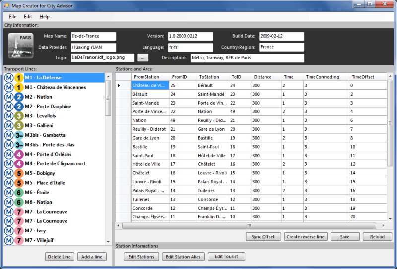
Note: Use the Map Creator to create public transportation maps for use with City Advisor.
· Dynamic depth algorithm
· All graphical, Touch Operation
· Optimized for High-Res screens
· Intelligence Search result
· Map Management
What's New in This Release:
· Rebuilt engines by managed code.
· A Station viewer makes possible to view all transports passed-by and next departures.
· Tourist attractions updated.
· Scrollbars for station selection and map selection
· Tourist site information window, can navigate to an assigned url
· Now you can search with more options simultaneously
· Maps are now in new format, faster and smaller (XMLs are used to edit in MapCreator only)
· Map download - you can now download maps from your phone.
Like it? Share with your friends!
If you got an error while installing Themes, Software or Games, please, read FAQ.
Supported operating systems:
Windows Mobile 2003, Windows Mobile 5.0, Windows Mobile 6 Classic, Windows Mobile 6 Professional, Windows Mobile 6.1 Classic, Windows Mobile 6.1 Professional, Windows Mobile 6.5 Professional
Similar Software:
Travel Berlin, Germany - Illustrated Guide, Phrasebook and Maps. Travel Berlin, Germany - an illustrated city guide, phrasebook, and maps. Indulge Yourself with a personal tour guide on Your PDA. FREE General Information chapter and a map in the trial version.
Features
Fully illustrated.
Historical overviews.
Interesting facts.
Street Map, Transportation Maps, and more.
Museums hours and tickets info
Travel Great Smoky Mountains National Park - illustrated guide and maps Travel Great Smoky Mountains National Park - illustrated guide and maps. Indulge Yourself with a personal tour guide on Your PDA. FREE General Information and map in the trial.
Features
Fully illustrated.
Interesting facts.
Multiple Maps
Attractions.
The guide is loaded into the device memory.
No network access needed
TerraTrack Recorder 7 Route guidance in 3D view, makes navigation processes very simple and intuitive
Free Earth Elevation Map for PrettyMap/PrettyEarth Earth Elevation Map for PrettyMap/PrettyEarth - This is a medium-resolution, free Earth elevation map for PrettyMap and PrettyEarth. It contains one elevation sample per 4 km, approximately.
Note: large file (16 MB download, 55 MB after installing).
Note for PrettyEarth users: this map will be installed to Program FilesPrettyMapmaps
Rough Guides Map Washington DC Rough Guides Map Washington DC... These guides are a series of fantastic interactive maps.
Produced in conjunction with the premier travel publisher Rough Guides.
Discover and explore Washington DC using full colour interactive linked maps, in this simple to use PDA version of The Rough Guides Washington DC
Wizi Wizi is a free instant location sharing service which let you send your location to a friend via SMS or E-mail. Use Wizi to tell a friend where you are now or where you are going to meet. It uses your integrated or external GPS unit to find your location and show it on the map. If you have other friends using Wizi you can always find them on the map
Map4Fun Taipei Map4Fun Taipei - Going to Taipei? just download it for free!
Attractions and shops/hotels/restaurants... in Taipei... find coupons/POI instant video/communication links...on hand, and much more of major Asian cities at Map4fun.
1. Taipei Information.
2. Useful numbers.
3. Tourist attraction.
4. East Taipei area map.
5. Jhonshan area map
Gippos See your location on a map and share this information with your friends. See on a map your contact list users who didn't hide their locations and send messages to them
Map of Beijing (Chinese) / China for City Advisor Map of Beijing (Chinese) / China for City Advisor is a Chinese version of Beijing Metro map. Type the first letter of Pinyin to search.
Instructions:
1. Download the map (zip file)
2. Extract the files in /CityAdvisor/maps
3. Open CityAdvisor -> Maps icon -> Menu -> Refresh
4
Other Software by developer «Huaxing YUAN»:
Map of Shanghai (Chinese) / China for City Advisor Map of Shanghai (Chinese) / China for City Advisor - A Chinese version of Shanghai / China Metro map with all updated 10 metro lines. Find station with first letter of pinyin, ex: the keyword of Shanghai Railway Station is hcz.
1. Download the map (zip file)
2. Extract the files in /CityAdvisor/maps
3. Open CityAdvisor -> Maps icon -> Menu -> Refresh
4
Map of Lyon / France for City Advisor Map of Lyon / France for City Advisor. This map includes: 4 Metro, 4 Tramway, 2 Funiculaire, 1 Rhonexpress and 2 Bus.
Instructions:
1. Download the map (zip file)
2. Extract the files in /CityAdvisor/maps
3. Open CityAdvisor -> Maps icon -> Menu -> Refresh
4
PocketMinesweeper Minesweeper for Pocket PC is a FREE minesweeper game which runs on touch screen devices. Minesweeper has a multi-language interface which includes English, French and Chinese (Simplified and Traditional). You have 4 different levels to face. This game is developed on the HTC Diamond devices and tested both on Diamond and Touch Dual
Map of Amiens (French) / France for City Advisor Map of Amiens (French) / France for City Advisor - A map of Amiens' bus transport for City Advisor. Contains line 1 to 11 with full timetable.
Instructions:
1. Download the map (zip file)
2. Extract the files in /CityAdvisor/maps
3. Open CityAdvisor -> Maps icon -> Menu -> Refresh
4
Map Creator for City Advisor Map Creator for City Advisor - Create public transportation maps for use with City Advisor.
What's New in This Release:
· Enable Special TimeTable editing.
· Enable customize peeks.
· Enable CAX format map generation.
· Enable Language-Code Selection for accent insensitive search.
· Accent insensitive station search


")


 / China for City Advisor")
 / China for City Advisor")
 / Belgium (Belgique) for City Advisor")


 / France for City Advisor")
