Categories: Internet & Communications, Travel & Navigation
Upload date: 16 Jul 11
Developer: Dave McKellar
License: Freeware
Downloads: 15794 File Size: 123 Kb
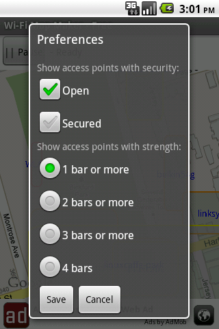
Wi-Fi Map Maker is application makes a map of Wi-Fi access points as you walk around.
· Maps out the actual coverage of each access point!
· Access point names are displayed on the map
· See street address and area of access points
· You can select the criteria for inclusion on your map.
· Info is saved in a database on your phone
· Supports landscape and portrait
· If hot spots overlap the strongest is put on top
What's New in This Release:
· More exit options
What's New in 1.3.6:
· Faster startup
· New option to follow your current location on the map
· You can hide the Pause/Record button so its not pressed accidentally
· App is slightly smaller (because ad code is now smaller)
What's New in 1.3.4:
· Prettier dialogs
Like it? Share with your friends!
Supported operating systems:
Google Android 1.5, Google Android 1.6, Google Android 10.x, Google Android 2.0, Google Android 2.1, Google Android 2.2, Google Android 2.3, Google Android 3.0, Google Android 3.1, Google Android 3.2, Google Android 4.0, Google Android 4.1, Google Android 4.2, Google Android 4.3, Google Android 4.4, Google Android 5.x, Google Android 6.x, Google Android 7.x, Google Android 8.x, Google Android 9.x
Similar Software:
Maps In My Pocket (MIMP) Maps In My Pocket - The main goal of this application is to allow its users to view maps, locate themselves, follow KML or GPX formatted tracks and getting directions from place to place.
What's New in This Release:
· New Icon
What's New in 1.4.3:
· Long press and long pinch concurrency on info bubble solved
Bagf Maps This is the first Map Application developed by Bagf, Inc. and in cooperation with Google, Inc. It is a honor for us to work with Google.. Also is it a honor to can share an Application that comes from us and Google! Enjoy!
London DK Eyewitness Top 10 Travel Guide & Map (BlackBerry) London DK Eyewitness Top 10 Travel Guide & Map (BlackBerry)- From the top 10 ways to experience Royal London to the top 10 shops, pubs and hotels - this guide features the insider knowledge that every visitor needs, plus London maps and metro maps.
Capture the essence of London, from shopping in Harrods to the Changing of the Guard at Buckingham Palace
InstaMapper (Android) InstaMapper is a free service that allows you to track a person or vehicle online in real time using a GPS-enabled mobile phone.
To use InstaMapper, you create a free account. Registration takes only a minute or two. All it is asked for is a username, password, and a valid email address.
Next, you install a small application on your GPS-enabled phone
Hollywood Star Maps Hollywood Star Maps - Welcome to Hollywood, California - Home of the world''s greatest stars! Search and find famous celebrity homes and locations in Los Angeles, California and make your next sightseeing tour all the more fun by driving yourself to the homes of the stars
TrekBuddy Trekbuddy is a J2ME application to be used with a GPS receiver. It is designed to work with every Java-enabled device. It features capabilities such as: * GPS tracking and simple navigation * bitmap maps (without zoom, you can store bitmap maps with different resolution instead)
Google (Android) Download the official Google app to your phone, and get easy access to Search, Maps, Mail, and more. Never say "I don't know" again
Android FindMyCar Android FindMyCar - Innovative software for Android devices that uses the GPS signal to show signs that allow to reach a geographic location.
Suitable for various uses (eg. find car parked in a parking area or in an unknown city, finding a person (who has sent their coordinates) in a lovely beach, in a fair, in another boat, find an area of sea fishing, etc..)
NAVIGON MobileNavigator NAVIGON MobileNavigator - Turn your Android phone into a mobile navigation device with lots of useful functions that will delight you! The pocket navigation device will show you the right way with functions such as Reality View Pro and Lane Assistant Pro
AugSatNav Walk AugSatNav is an augmented reality navigation system which overlays walking directions upon a live video feed of the path or road ahead.
With AugSatNav there is no need to follow instructions or interpret maps - you can simply find your way by walking along the route highlighted by a bright white line
Other Software by developer «Dave McKellar»:
TTC Subway Rider Efficiency Guide TTC Subway Rider Efficiency Guide - This application has maps of all TTC (Toronto Transit Commission) subway stations so you can see where the stairs/etc are... and plan where to stand on the platform.
Based on ttcrider.ca
Useful for handicapped people too
Hockey Team Hockey Team - For the coach or captain of a recreational hockey team.
Given the number of players who showed up in the dressing room... how many forwards and how many defense is that?!
Also suggests how you might divide up your forwards.
Language is gender-neutral so you can use it for girls/women teams too.
Please note: this application is *not* a game
XBMC Server - Free Let your friends select the music that plays on your mobile phone!
HashPost - Free HashPost - Free - A special purpose Twitter application. Its sole purpose in life is to make it easy for you to include #lots of #hashes in your Tweets. Ideal for Live Tweeting an event.
Profile Hashes:
· Enter them once and they are always included
Dividend Predictor - Free Dividend Predictor - For the dividend investor.
Enter the symbols of stocks you own, the application looks up the details online and shows what future dividends you'll get.
Do you have a mix of regular stocks that pay quarterly and ETFs that pay monthly? -- no problem.
Or for "what if", enter stocks you might want to buy and see how they pay


")
")
")


")


