IATA / ICAO Dictionary -This application is an offline database for IATA / ICAO airport, airline, aircraft, delay codes and aircraft registration codes.
The airport database provides:
- Name
- Elevation
- Latitude and Longitude coordinates,
- timezone,
- runway and communication information (not every airport)
- Metar / TAF reports (not every airport)
- google map (not every airport)
- sunrise / set calculation
- find other airport in the vicinity of the selected airport or from your present position (GPS required)
- calculate the distance to the selected airport (GPS required)
The airline database provides:
- Name
- Country
- Callsign
- picture of the airline with airliners.net
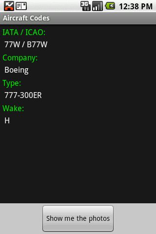
The aircraft database provides:
- Company
- Type
- wake category
- picture of the aircraft with airliners.net
Other functions are:
AC registrations; selection by
- country - registration
- registration - country
Delay codes
general aviation abbreviations
Like it? Share with your friends!
Supported operating systems:
Google Android 1.5, Google Android 1.6, Google Android 10.x, Google Android 2.0, Google Android 2.1, Google Android 2.2, Google Android 2.3, Google Android 3.0, Google Android 3.1, Google Android 3.2, Google Android 4.0, Google Android 4.1, Google Android 4.2, Google Android 4.3, Google Android 4.4, Google Android 5.x, Google Android 6.x, Google Android 7.x, Google Android 8.x, Google Android 9.x
Similar Software:
Hong Kong Transport Hong Kong Transport - Hong Kong Transport App provides a useful guide for you to go around Hong Kong streets by public transport
Boston Metro This app grants you fast acces to the last Boston metro map, no internet connection needed once it has been installed. Full zoom controls. Fast, light and simple
MetrO (Android) MetrO helps you find your way in the public transportation in more than 400 cities around the world
Yurtdisina Çikma Rehberi Yurtdisina cikarken ihtiyaciniz olan her seyi detayi ile bulabileceginiz guncel bir uygulama
Places you cant Visit Places you cant Visit - While most people are happy just taking the occasional trip to the beach, there are those of us that long for something more…an adventure. And although most places on Earth are accessible to the determined traveler, some places are just better off left alone
Citybike Stationen Wien Zeigt eine Liste der Wiener Citybike Stationen nach der Entfernung vom aktuellen Standort geordnet an. Fur jede Station ist die Anzahl der freien Rader, die Anzahl der freien Boxen, sowie der Standort ersichtlich. Bitte Hinweise unter Menu / About beachten (Beta Version)!
Trip Journal for Android Trip Journal for Android - Trip Journal is a handy mobile application that allows travelers to record the details of their trip using their Android smartphones. The app uses the GPS receiver of your mobile device to record your route and shows the path you have taken on a map, making it easy to retrace your steps
Funtime America Funtime America - Welcome to FunTime America. New Jerseys most innovative indoor amusement park. Funtime America hosts the newest and most interactive video games, amusement rides, and lasertag. We are also known through out the state for our unbeatable party packages and pricing
FERNBUSSUCHE - Finde Deine nächste Fernbusreise FERNBUSSUCHE - Finde Deine nächste Fernbusreise - FERNBUSSUCHE | Finde, vergleiche und buche die aktuellsten Fernbusreise-Angebote, Unterkünfte und Städtereisen auf Deinem Smartphone
Other Software by developer «Steve Dexter»:
Guess the X Guess the X - With this game you can guess a flag, a capital, a land and boundaries.
There are four input methods available to enter the answer: an autocomplete editbox, via a listview, multiple choice and a tap mode.
There are also options to change the color, size and font
Snowtam Decoder Snowtam Decoder - You have a snowtam in the metar report, you want to decode. Snowtam Decoder does it for you.
· Decoding of a snowtam in metar format
· Explanation of the items (A ,B , C, ..
Aviation Weather with Decoder Aviation Weather with Decoder - An easy way to receive metar and TAF reports from NOAA

")


")


