Symbian OS | Pocket PC | Smartphone | Android | BlackBerry | Apple iPhone OS | Java | Mobile Gaming | Linux | Palm | Win CE | Tablet  
     

Free Mobile Software, Themes, Games, Apps for PDA and Smartphones

     
Search by Device
My Device

  
Search by Category
Business & Profession
Databases
Dictionary & Translator
Entertainment
Finance
Games
Healthcare & Medicine
Internet & Communications
Multimedia & Graphics
Organisation & Productivity
Programming & Development
Reading
Science & Education
System Utilities
Themes & Wallpapers & Skins
Travel & Navigation
Search by Platform
Android
Apple iPhone OS
iPad
iPhone
iPod Touch
BlackBerry
Java
Linux
Maemo Nokia Internet Tablet
MeeGO
Sharp Zaurus
Mobile Gaming
Nintendo DS
Playstation 3
Playstation Portable
Wii
Xbox 360
Palm OS
Symbian OS
Series 60
Series 80
Series 90
UIQ
Tablet PC
Windows CE.NET
Windows Mobile Pocket PC
Windows Mobile Smartphone


Achivx Partner
 
 
RMaps


RMaps
Version: 0.9.4 updated

Platforms: Android


Categories: Travel & Navigation

Upload date: 29 Jun 13

Developer: RobertK506

License: Freeware

Downloads: 23756

File Size: 722 Kb
Download Free RMaps 


Rating: 2.8/5 (Total votes: 59)


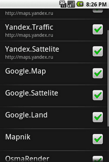
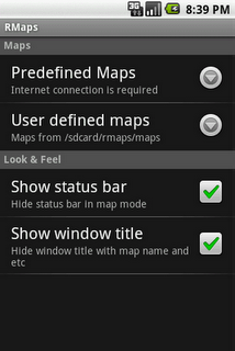
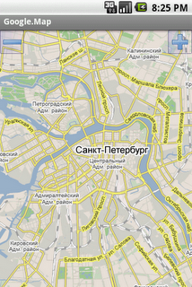
RMaps is a navigation tool. You can use RMaps as an online map viewer for some popular maps. And as an offline map viewer for your own maps created on the PC.
· Auto rotate map in driving direction.
· Auto rotate map in the northern direction.
· Compass on the map.
· Auto-follow function.
· Online search.
· Full screen mode.
· GPS and wireless network mode.
· Indicator accuracy like on Google map.

What's New in This Release:

· Dashboard. Long press on dashboard to add or change value
· I am here: Long press on the screen to point your location without GPS
· Target point (use the map context menu)
· Ability to use volume controls to zoom map
· Ability to export import POI category with the POI
· Ability to use custom cursors
· Ability to download online map directly to online cache
· Updated URLs
· Improving downloader service, Track writer service
· Fixed some GPX importing bugs

What's New in 0.9.3.1:

· Fixed add POI, search bugs

What's New in 0.9.3:

· Been improved measure tool
· Ability to use the app on a devices without GPS
· Long press on the map now shows the coordinates etc. Clicking on a black bubble shows the context menu
· Coordinates formatting preference
· Ability set Zoom controls at the right
· Ability download to offline a layers
· Build-in ability to download Geology and Geophysics offline maps from www.dpi.nsw.gov.au/minerals
· Fix scale bar bug
· Fix some POI bug

What's New in 0.9.2:

· Opened Google Community RMaps on Google+ (users support, beta testing)
· Measuring distances (Menu - Tools - Measure)
· Distance circles around current location
· Joining multiple tracks into one
· New Relief map
· Reload/update tiles tool on the screen online map (Menu - Tools - Reload screen tiles)
· OSGB 36 for offline Ordnance Survey Map
· Compass fix
· Loading circles after download fix
· White POI on SONY fix
· Google.Land, Google.Satellite fix

What's New in 0.9.1:

· BING maps (Road, Aerial, Hybrid)
· USA Topo maps, ArcGIS USA maps, USGS Topo maps
· Improve usability of POI category list
· Improve usability of maps list in settings
· Line between current GPS location and center of screen
· Share POI function
· Altitude field in POI activity
· Map offset function (useful for Chinese users)
· Stretch factor of map, ability to enlarge picture of any map
· Offline maps bug fix

What's New in 0.9.0.1:

· Debug bug fix
· Correct translation

What's New in 0.8.9:

· Crosshair on center of the map
· Added new map maps.refuges.info
· Bug fix

What's New in 0.8.7.3:
· New preference Directory
· Now RMaps stores tiles of online maps on sdcard in sqlite format

What's New in 0.8.6.1:
· Bug fix

What's New in 0.8.6:
· New maps: VFR (avcharts.com), MyTopo, OSM MTB Mapa Česká republika
· Error report
· Bug fix: Multitouch, Scale bar, more

What's New in 0.8.5:
· Scale bar, Units property

What's New in 0.8.4.1:
· Multitouch zooming
· Zoom buttons settings: top, bottom, hide

What's New in 0.8.3.1:
· Fix export track to GPX, KML file


Like it? Share with your friends!
 

Supported operating systems: Google Android 1.0, Google Android 1.5, Google Android 1.6, Google Android 10.x, Google Android 2.0, Google Android 2.1, Google Android 2.2, Google Android 2.3, Google Android 3.0, Google Android 3.1, Google Android 3.2, Google Android 4.0, Google Android 4.1, Google Android 4.2, Google Android 4.3, Google Android 4.4, Google Android 5.x, Google Android 6.x, Google Android 7.x, Google Android 8.x, Google Android 9.x
 
Similar Software:

ProntoPronto
Pronto is a simple GPS tracker for outdoor activities, such as walking, running and cycling
LocateMyBuddyPROLocateMyBuddyPRO
LocateMyBuddy(aka LMB) is a GPS tracker and having features like "GPS Group/Friends Tracker" + "GPS Navigator" + "Friend Finder" + "GPS Location Sharing with Map URL" + "Follow Me" + "Email/Text service" + "Hybrid/Standard Map" + "GPS Location Address display Along With GPS Co-ordinates"
Speedometer GPSSpeedometer GPS
Speedometer GPS - Speedometer GPS  can track your speed,distance,time,location and also can get start time,time elapased,avg speed,max speed,altitude... Features included - Save your track info,Record gpx file(it will be saved in "sdcard/SpeedometerGPS/gpx/").. - Switch between car speedometer and bike cyclometer. - Switch between mph or km/h mode
MySpeedMySpeed
MySpeed will record your speed and location to a log file and show it on a map. It can use a database of speed camera locations to alert you when you're near a speed camera. There is no speed camera database included. You'll need to download the data from a site such as scdb.info, flitspaal.nl, pocketgpsworld.com, maparadar.com, etc
RedpinRedpin
The aim of the Redpin project is to create an open source system that allows indoor positioning up to room-level description using mobile phones
Yandex navigatorYandex navigator
Yandex navigator - is a useful application which will easily make the best route for you by means of GPS, taking into consideration traffic jams and other road situations. Voiced hints are available which will inform you on accidents or roads under repair. The application will offer several routes. During the dark part of a day night mode is available
GPS Signal WidgetGPS Signal Widget
GPS Signal Widget - Do you get tired waiting for the GPS location to be available? With this tool you can check out the GPS satellites and the signal strength in just a nice 1X1 widget. The spokes in the widget represents the satellites and the length of the spokes is a measure of the signal strength. Enable or disable the widget by tapping on the widget
Open GPS TrackerOpen GPS Tracker
Open Source recording, storing and accessing of your routes: Open GPS TrackerAn application that can track your travels of your Android by storing your GPS locations. Draws the route real-time on either Google or OSM maps
OSMTracker for AndroidOSMTracker for Android
OSMTracker stands for OpenStreetMap Tracker. It allows you to track your journey and mark significant way points. Way points can be marked with a tag using a button, with a quick voice record, a text note or by taking a picture. The various button pages and layouts can be customized to suit your OpenStreetMap activities
EcoDrive Free SpeedometerEcoDrive Free Speedometer
EcoDrive Free Speedometer - EcoDrive Free Speedometer - accurate and convenient GPS speedometer. The app is designed to control the speed, economy, time, direction, etc. Real-time economy calculations is based on the speed, acceleration and braking, descents and ascents
 

Other Software by developer «RobertK506»:

not found
 

Comments on RMaps:

Matt Murphy:
Cool I want to give this a shot.

Date: 23 Jul 10

Name:


Comment:


Enter text from image below:

Turn on images!


If you noted an error or download link is broken, please, report it via this page or use comments.
 

RMaps is compatible with your device Lenovo LePhone S720
 
 
© Pantich 2009 - 2025 All rights reserved.