Symbian OS | Pocket PC | Smartphone | Android | BlackBerry | Apple iPhone OS | Java | Mobile Gaming | Linux | Palm | Win CE | Tablet  
     

Free Mobile Software, Themes, Games, Apps for PDA and Smartphones

     
Search by Device
My Device

  
Search by Category
Business & Profession
Databases
Dictionary & Translator
Entertainment
Finance
Games
Healthcare & Medicine
Internet & Communications
Multimedia & Graphics
Organisation & Productivity
Programming & Development
Reading
Science & Education
System Utilities
Themes & Wallpapers & Skins
Travel & Navigation
Geocaching
GPS
Guides
Maps
Measuring & Compass
Travel Planning
Weather
Worldtime
More
Search by Platform
Android
Apple iPhone OS
iPad
iPhone
iPod Touch
BlackBerry
Java
Linux
Maemo Nokia Internet Tablet
MeeGO
Sharp Zaurus
Mobile Gaming
Nintendo DS
Playstation 3
Playstation Portable
Wii
Xbox 360
Palm OS
Symbian OS
Series 60
Series 80
Series 90
UIQ
Tablet PC
Windows CE.NET
Windows Mobile Pocket PC
Windows Mobile Smartphone


Achivx Partner
 
 
OSMTracker for Android


OSMTracker for Android
Version: 0.6.4 updated

Platforms: Android


Categories: Travel & Navigation

Upload date: 11 Apr 13

Developer: Nicolas Guillaumin

License: Freeware

Downloads: 8596

File Size: 1184 Kb
Download Free OSMTracker for Android 


Rating: 2.5/5 (Total votes: 48)


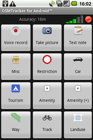
OSMTracker stands for OpenStreetMap Tracker. It allows you to track your journey and mark significant way points. Way points can be marked with a tag using a button, with a quick voice record, a text note or by taking a picture. The various button pages and layouts can be customized to suit your OpenStreetMap activities. You can view your current track on top of an OpenStreetMap background.
The track is then exported in GPX format, ready to use in OSM tools like JOSM.
This project has been mainly inspired by the great OSMTracker for Windows Mobile devices.

What's New in This Release:

· Allow installation on SD Card.
· Updated icons.
· Updated translations.

What's New in 0.6.3:

· Fix OSM upload on Android 3 and more.
· Fix issue with non-ASCII characters in OSM upload.
· Retain original filename when uploading.
· Updated translations.

What's New in 0.6.2:

· Fixed menu not appearing on Android 3+ devices.
· Various changes for Transifex compatibility.

What's New in 0.6.0:
· Upload tracks to OpenStreetMap.
· Mass GPX-export of tracks.
· Fix issue with GPX files invisible on some phones (Galaxy Nexus).

What's New in 0.5.8:
· Way points are now displayed on the map.
· Minor bug fixes in GPX export.
· Updated translations: IT, IW, FR, RU, NN, NB.

What's New in 0.5.8:
· Now requires Android 2.1.
· Fix for background tracking unexpectedly stopping and parts of track lost for Android 2.x and after.
· Track list now shows the most recent first.
· Access way points list from track details screen.
· Minor layout fixes and improvements.
· Minor OSM background map improvements.
· Ensure GPX files are XML schema-compliant
· Updated translations: NO, PL, RU, JA, FR.

What's New in 0.5.6:
· Fixed bug when using internal memory for storage
· Added menu to delete all tracks at once
· Various minor improvements
· Updated translations: SK, NN

What's New in 0.5.5:
· Fixed Market packaging issue

What's New in 0.5.3:
· Fixed screen rotation issues when entering a note.
· Fixed GPS logging interval handling.
· Fixed notification problems.
· Screen can now automatically be turned off.
· Ability to pause and resume tracking.
· Ability to stop tracking from the track list.
· Performance improvements on track list.
· New/updated translations: Slovak, Italian, German, Brazilian Pt.

 What's New in 0.5.1:
· Various bug fixes.
· Updated DE translation.
· Ability to display a previous track from the track list.

 
Like it? Share with your friends!
 

Supported operating systems: Google Android 1.5, Google Android 1.6, Google Android 10.x, Google Android 2.0, Google Android 2.1, Google Android 2.2, Google Android 2.3, Google Android 3.0, Google Android 3.1, Google Android 3.2, Google Android 4.0, Google Android 4.1, Google Android 4.2, Google Android 4.3, Google Android 4.4, Google Android 5.x, Google Android 6.x, Google Android 7.x, Google Android 8.x, Google Android 9.x
 
Similar Software:

BigTinCan Mapper Free Edition (Android)BigTinCan Mapper Free Edition (Android)
View your world on a dynamic map and add to your map using OpenStreeMap
Locus FreeLocus Free
Locus Free - Fast and useful Online/Offline map viewer for Android. · This is also My Maps editor so Google Account permission is needed · Contacts permission is for getting contact address on various places in app (adding point into database by contact address, etc..
Street View on Google MapsStreet View on Google Maps
Street View on Google Maps - New! Street View smart navigation -- move around by dragging "Pegman" where you want to go. Try Street View on Google Maps to view street-level imagery from your phone. To use Street View, open Google Maps, search for a place or long-press the map, and tap the Street View option
Osmand: Maps and NavigationOsmand: Maps and Navigation
Osmand: Maps and Navigation - is a navigation utility. Support of electronic maps gives you a chance to get new updates all the time. The map has marks which will help tourists. Embedded satellite navigation allows you to make the shortest route fast
Outdoor Offline Maps for AndroidOutdoor Offline Maps for Android
Outdoor Offline Maps for Android - The Outdoor Navigation software is your best friend through your adventures in the wild. Go into the outdoors with confidence and enjoy your activities without worrying about the tools to help you navigate. Your Outdoor Navigation app is made by the people who have been developing this software since 2003 across multiple platforms
maps PROGOROD for ANDROIDmaps PROGOROD for ANDROID
Maps for Auto Navigation GPS(Russia)
ClapCardClapCard
ClapCard is a free social network for creating and sharing animated cards directly from Android based phones
AugSatNav WalkAugSatNav Walk
AugSatNav is an augmented reality navigation system which overlays walking directions upon a live video feed of the path or road ahead. With AugSatNav there is no need to follow instructions or interpret maps - you can simply find your way by walking along the route highlighted by a bright white line
Wi-Fi Map Maker - FreeWi-Fi Map Maker - Free
Wi-Fi Map Maker is application makes a map of Wi-Fi access points as you walk around. · Maps out the actual coverage of each access point! · Access point names are displayed on the map · See street address and area of access points · You can select the criteria for inclusion on your map
GeosearchGeosearch
Geosearch is a free/open source application which allows you to monitor the movement of users on a Google map. You can send SMS, make calls and find the optimal road to reach another user
 

Other Software by developer «Nicolas Guillaumin»:

not found
 

Comments on OSMTracker for Android:

Comments not found

Name:


Comment:


Enter text from image below:

Turn on images!


If you noted an error or download link is broken, please, report it via this page or use comments.
 

OSMTracker for Android is compatible with your device Koobee MAX2 X9
 
 
© Pantich 2009 - 2025 All rights reserved.