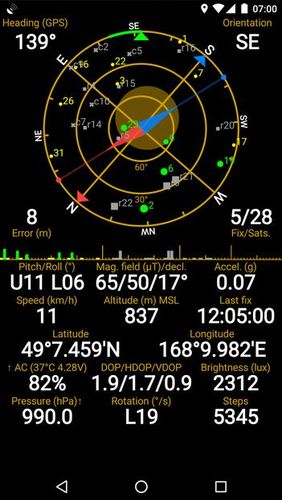
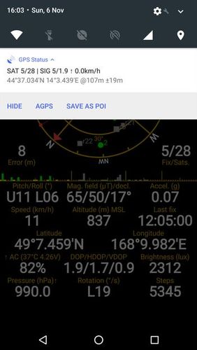
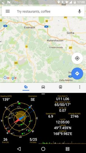
GPS status & toolbox - is a very useful program for working with GPS. This utility is aimed at viewing GPS condition and settings. It can display all data of a sensor and GPS: positions and satellite signal power, accuracy, speed, acceleration, height, step and even battery status.
Game features:
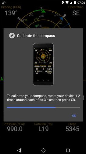
Magnet compass with accurate north
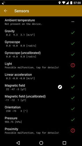
All data of a sensor and GPS
Fast search
Simple and comprehensive interface
Loading video...
Like it? Share with your friends!
Supported operating systems:
Google Android 4.1, Google Android 4.2, Google Android 4.3, Google Android 4.4, Google Android 5.x, Google Android 6.x, Google Android 7.x, Google Android 8.x
Similar Software:
Modern Compass Modern Compass this compass does what the compass always was intended to do, it helps you locate the destination of your choice.
Using GPS technology and Google maps, this application lets you mark a destination of choice and then shows in what direction that destination lies, as well as how far away it is from your current location
MySpeed MySpeed will record your speed and location to a log file and show it on a map.
It can use a database of speed camera locations to alert you when you're near a speed camera.
There is no speed camera database included. You'll need to download the data from a site such as scdb.info, flitspaal.nl, pocketgpsworld.com, maparadar.com, etc
Waze Waze is a free, 100% user-generated, social navigation application that allows drivers to build and use live maps & real-time traffic updates to improve their daily commute
meet-me FREE meet-me With only a few fingertips you can find your friends in the biggest crowd. Their location is presented by a stylish arrow and distance. Awesome: the positions are dynamically updated
Zeen - Building Road Awareness Zeen, building road awareness together! Zeen is a fully featured, community driven mapping solution. - Over 500,000 data points at launch! Will continue to build thanks to the community! - Police Locations - Red Light Camera Locations - Speed Camera Locations - Traffic Reports / Locations
Polaris Navigation System Polaris Navigation System - The Polaris Navigation System is a powerful navigation software for Android. It includes all the standard GPS functionality, including an odometer, altimeter, speedometer and directional compasses.
The app also allows you to record trails and view them on a map
AnyLocation AnyLocation - AnyLocation is the most professional app for mobile location mock, which can perfectly mock GPS location on LBS app, for example facebook, wechat, momo and so on. The most powerful ability of AnyLocation is: 1 It can mock without the system setting "allow mock locations" enabled(root required). 2 It can block cell-ID location
AugSatNav Walk AugSatNav is an augmented reality navigation system which overlays walking directions upon a live video feed of the path or road ahead.
With AugSatNav there is no need to follow instructions or interpret maps - you can simply find your way by walking along the route highlighted by a bright white line
AntipodalPoint AntipodalPoint retrieves you position from the network provider or GPS and calculates and shows you antipodal point - the place exact opposite of you on Earth.
AntipodalPoint Pro enables you to browse the entire world and find antipodal points
Comments on GPS status & toolbox:
rob:
Nice
Date: 7 Nov 21
If you noted an error or download link is broken, please, report it via this page or use comments.
GPS status & toolbox is compatible with your device KDDI INFOBAR A02 HTX21 (HTC Iimpression)

")