GPS data pusher, the current geographic position can be send in a special SMS message
Navigation with turn by turn route guidance in 3D view, cost advantage - don''t need internet connection, don''t need a map
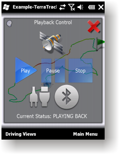
GPS simulator, playing back of recorded tracks
Route guidance in 3D view, makes navigation processes very simple and intuitive.
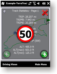
Recorded Track: Statistical analysis of track point information.
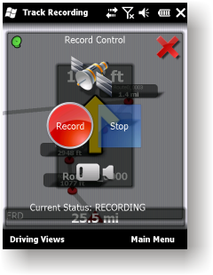
Track recording. Full NMEA-0183 format compatibility.
Playing back to your desktop PC''s NMEA-0183 Navigation software (Microsoft Streets and Trips 2010, Google Earth and many others). Virtual Serial Port (COM port) Driver for playing back at the same Windows phone.
Like it? Share with your friends!
If you got an error while installing Themes, Software or Games, please, read FAQ.
Supported operating systems:
Windows Mobile 2003, Windows Mobile 5.0, Windows Mobile 6 Classic, Windows Mobile 6 Professional, Windows Mobile 6.1 Classic, Windows Mobile 6.1 Professional, Windows Mobile 6.5 Professional
Similar Software:
AccountingGPS AccountingGPS - Each sheet has the GPS home setting and you can use the GPS on your PocketPC to view the distance of every sheet. Select the sheet to view/edit the entry for it. You can also view a Google.com map of your current or the sheets GPS
LocationSMS LocateSMS permit to include your GPS-coordinates into a SMS
amAze (LG) AmAze is a first of its kind free navigation and local search service. It is free to download and use and it contains wide coverage of maps including aerial photo in Europe, North America, Australia and parts of Asia and Africa
GPS LOG GPS LOG - The program shows the following values:
Total values
Total travel time
Total distance covered
Average speed of the total distance
Total distance travel time covrered with less than 3 mph (e.g. traffic jam, red lights..
myRadar myRadar is a location aware radar application that makes use of Wunderground and Accuweather US web services to show real-time, animated Radar Images of your local area regardless of where in the US you might be. This application requires myLocation services to function automatically.
The program will install to /Program Files/myRadar
GPSSpeedometerer GPSSpeedometerer uses the GPS on your PocketPC to find your speed based on the NMEA RMC sentence
gvSIG Mobile gvSIG Mobile is a tool oriented to manage geographic information. It is characterized by a user-friendly interface, with a quick access to the most usual raster and vector formats
FON Access Points for Guadaloupe FON Access Points for Guadaloupe - FON offers you a new Points of Interest service (POIs). This allows you to download FONspots directly to your navigation device.
What does that mean? You can download a Points of Interest file directly to your navigation device
FON Access Points for Nicaragua FON Access Points for Nicaragua - FON offers you a new Points of Interest service (POIs). This allows you to download FONspots directly to your navigation device.
What does that mean? You can download a Points of Interest file directly to your navigation device
FON Access Points for Colombia FON Access Points for Colombia - FON offers you a new Points of Interest service (POIs). This allows you to download FONspots directly to your navigation device.
What does that mean? You can download a Points of Interest file directly to your navigation device
Comments on TerraTrack Recorder 7:
Comments not found
If you noted an error or download link is broken, please, report it via this page or use comments.
TerraTrack Recorder 7 is compatible with your device iPAQ rx3715


")


