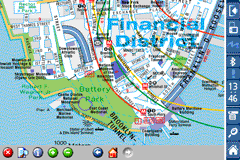
Rough Guides Map New York City... These guides are a series of fantastic interactive maps.
Produced in conjunction with the premier travel publisher Rough Guides.
Discover and explore New York City using full colour interactive linked maps, in this simple to use PDA version of The Rough Guides New York City.
Find all the top tourist spots and key attractions with ease, information on the city and its sights can be quickly displayed with links to photographs and map locations. All in a superb easy to use interface.
If you''re travelling to New York City, be sure you don''t leave home without this guide on your PDA.
The Rough Guide city maps includes:
Fully scrollable and interactive maps of the city.
Tap any location to display information and available links.
Intuitive navigation bar meaning you are never more than one click away from the information you require.
Map links allow you to directly link to other maps, photographs, or detailed views.
Categorised Find feature allowing you to quickly find any street, place of interest or station.
Categorised Information feature providing a wealth of information on the city, places of interest, etc.
1-Click Home feature, keeping the Home map always at hand.
Zoom function on all maps.
Special Offer Only $20.00
Hi Res & landscape displays supported.
Like it? Share with your friends!
If you got an error while installing Themes, Software or Games, please, read FAQ.
Supported operating systems:
Pocket PC 2002, Windows Mobile 2003, Windows Mobile 5.0, Windows Mobile 6 Classic, Windows Mobile 6 Professional, Windows Mobile 6.1 Classic, Windows Mobile 6.1 Professional, Windows Mobile 6.5 Professional
Similar Software:
Map of Senegal Map of Senegal - A map of Senegal. Good for intercity travels with SmartMap.
Layers include:
Towns
Settlements
Airports
Roads
Railroads
Rivers
Inland water
Administrative borders
International borders
Trees
Map scale is 1:1 million.
Good for use with any version of SmartMap. SmartMap can be purchased here
redBANG Hong Kong 18 TOP SIGHTS 2006 THE BEST MOBILE GRAPHICS YOU HAVE EVER SET YOUR EYES ON
This TOP 18 sights map contains all THE TOP locations at your finger tips. Simple and easy to use multi step zoom in & out function map as well as movement in any direction
Map of Western Siberia Map of Western Siberia - A map of Western Siberia. Includes following regions:
ALTAYSKIY KRAY
KEMEROVSKAYA OBLAST''
NOVOSIBIRSKAYA OBLAST''
OMSKAYA OBLAST''
RESPUBLIKA ALTAY
TOMSKAYA OBLAST''
Good for intercity travels with SmartMap
MetrO (Windows Mobile) Metro finds your way in public transport systems in more than 350 cities around the world (Paris, New York, London, Tokyo, any city with a subway & many more!).
FREE, FAST & ACCURATE
Map of New Jersey (US State) Map of New Jersey (US State) - A map of the New Jersey by VITO Technology. Good for intercity travels with SmartMap.
SmartMap is a mobile device application which uses vector and raster maps. It is compatible with any NMEA protocol GPS receiver (Compact Flash socket, serial port, BlueTooth or sleeve)
Map of Sri Lanka Map of Sri Lanka - A map of Sri Lanka. Good for intercity travels with SmartMap.
Layers include:
Towns
Settlements
Airports
Roads
Railroads
Rivers
Inland water
Administrative borders
International borders
Trees
Map scale is 1:1 million.
Good for use with any version of SmartMap. SmartMap can be purchased here
KingMAP2 USA-New York Electronic Map KingMAP2 USA-New York Electronic Map is an Electronic Map Navigation Software exclusively for Pocket PC use; besides powerful functions provided for car navigation, it also comprises integrated Electronic Map functions with an abundant information database.
KingMAP™ 2 Features:
-Latest version Europe electronic map database*
-Advanced Car Navigation Technology
Map of HongKong for City Advisor Map of HongKong for City Advisor - HongKong MTR map in Traditional Chinese for City Advisor. The stations can be find by Chinese characters and also by the first pinyin letters.
Instructions:
1. Download the map (zip file)
2. Extract the files in /CityAdvisor/maps
3. Open CityAdvisor -> Maps icon -> Menu -> Refresh
4
Other Software by developer «Visual IT»:
Tube 2 Barcelona (UIQ) Tube 2 Barcelona (UIQ) - This map package for Tube 2 consists of a fully scrollable detailed map of the Barcelona metro & rail system.
Plan journeys on the metro system, list details of the quickest routes and see a superb animated display of your journey tracking around the system map
Tube 2 Munich (UIQ) Tube 2 Munich (UIQ) - This map package for Tube 2 consists of a fully scrollable detailed map of the Munich metro, rail & tram system.
Plan journeys on this system, list details of the quickest routes and see a superb animated display of your journey tracking around the system map.
Munich is the capital city of Bavaria, the southern most German federal state
Tube Singapore (UIQ) Tube Singapore (UIQ) - An award winning and highly acclaimed application that guides you around the metro system of Singapore.
An essential addition to your Sony Ericsson P800 / P900 / P910 if you travel in or around this city
· A detailed clear colour map of the Singapore metro system fully scrollable.
· Quick find station utility
Tube London City Streets (2009 Edition) Tube London City Streets
This Tube package consists of a fully scrollable detailed map of the London Underground system and 9 linked GPS enabled A-Z street maps.
Plan journeys on the London Underground system, list details of the quickest routes and see a superb animated display of your journey tracking around the system map
Tube 2 Berlin (Palm OS) Tube 2 Berlin (Palm OS) - This map package for Tube 2 consists of a fully scrollable detailed map of the Berlin Metro (U-Bahn/S-Bahn).
Plan journeys on this system, list details of the quickest routes and see a superb animated display of your journey tracking around the system map.
Berlin is the capital and largest city in Germany
Tube 2 Madrid Pro (UIQ) Tube 2 Madrid Pro (UIQ) - This map package for Tube 2 consists of a fully scrollable detailed map of the Madrid metro system and linked street maps of central Madrid.
Plan journeys on the metro system, list details of the quickest routes and see a superb animated display of your journey tracking around the system map
Tube 2 Chicago Pro (Palm OS) Tube 2 Chicago Pro (Palm OS) - This map package for Tube 2 consists of a fully scrollable detailed map of the Chicago metro & commuter rail system and linked street maps of central Chicago.
Plan journeys on the metro system, list details of the quickest routes and see a superb animated display of your journey tracking around the system map
Barcelona Metro for iPad by Zuti Barcelona Metro for iPad by Zuti - This Zuti application contains a visually unique map of the Barcelona transport system and a superb animated journey planner to help you get around the TMB (Transports Metropolitan de Barcelona), FGC (Ferrocarrils de la Generalitat de Catalunya) Metro and Tram services
London Bus by Zuti London Bus by Zuti - The new Zuti London Bus map has finally arrived, making it easy to travel by bus anywhere in central London. This clear and colourful map covers a detailed street level area of 6 miles by 4 miles and includes over 1300 bus stops and 189 bus routes
Tube 2 Chicago Pro (UIQ) Tube 2 Chicago Pro (UIQ) - This map package for Tube 2 consists of a fully scrollable detailed map of the Chicago metro & commuter rail system and linked street maps of central Chicago.
Plan journeys on the metro system, list details of the quickest routes and see a superb animated display of your journey tracking around the system map


 Hi Res & landscape displays supported.
![USA-OH [Ohio] Map for EagleEye PDA Tracking System](https://static.mobyware.org/data/images/def_program_reduced.png "USA-OH [Ohio] Map for EagleEye PDA Tracking System")


")
")


")
")
")
")
")
")
")


")