City Advisor is a Public Transport Navigation Platform for Windows Mobile, providing generic path searching services for cities.
Note: Use the Map Creator to create public transportation maps for use with City Advisor.
· Dynamic depth algorithm
· All graphical, Touch Operation
· Optimized for High-Res screens
· Intelligence Search result
· Map Management
What's New in This Release:
· Rebuilt engines by managed code.
· A Station viewer makes possible to view all transports passed-by and next departures.
· Tourist attractions updated.
· Scrollbars for station selection and map selection
· Tourist site information window, can navigate to an assigned url
· Now you can search with more options simultaneously
· Maps are now in new format, faster and smaller (XMLs are used to edit in MapCreator only)
· Map download - you can now download maps from your phone.
Like it? Share with your friends!
If you got an error while installing Themes, Software or Games, please, read FAQ.
Supported operating systems:
Windows Mobile 2003, Windows Mobile 5.0, Windows Mobile 6 Classic, Windows Mobile 6 Professional, Windows Mobile 6.1 Classic, Windows Mobile 6.1 Professional, Windows Mobile 6.5 Professional
Similar Software:
redBANG Beijing Map-Guide NEW 2006 THE BEST MOBILE GRAPHICS YOU HAVE EVER SET YOUR EYES ON
This City map-Guide contains all THE TOP locations at your finger tips. Simple and easy to use, simply zoom in & out of this jpg map or move N, E, S or West
MyTravelr Mytravelr is a set of tools designed to help on-the-go mobile users maximize their productivity and reduce the stress of trave.
1.0F3 version:
- Fixed bug: some cities DST issue.
- Fixed bug: Weather update from forecast screen.
- Added: Option for disabling Internet Network confirmation.
1.0F2 version:
- Added: Edit cities feature (Add/Update/Delete)
Map of Rhode Island (US State) Map of Rhode Island (US State) - A map of the Rhode Island by VITO Technology. Good for intercity travels with SmartMap.
SmartMap is a mobile device application which uses vector and raster maps. It is compatible with any NMEA protocol GPS receiver (Compact Flash socket, serial port, BlueTooth or sleeve)
Map of Uruguay Map of Uruguay - A map of Uruguay. Good for intercity travels with SmartMap.
Layers include:
Towns
Settlements
Airports
Roads
Railroads
Rivers
Inland water
Administrative borders
International borders
Trees
Map scale is 1:1 million.
Good for use with any version of SmartMap. SmartMap can be purchased here
Map of Wisconsis (US State) Map of Wisconsis (US State) - A map of the Wisconsis by VITO Technology. Good for intercity travels with SmartMap.
SmartMap is a mobile device application which uses vector and raster maps. It is compatible with any NMEA protocol GPS receiver (Compact Flash socket, serial port, BlueTooth or sleeve)
Map of Senegal Map of Senegal - A map of Senegal. Good for intercity travels with SmartMap.
Layers include:
Towns
Settlements
Airports
Roads
Railroads
Rivers
Inland water
Administrative borders
International borders
Trees
Map scale is 1:1 million.
Good for use with any version of SmartMap. SmartMap can be purchased here
Map of South Dakota (US State) Map of South Dakota (US State) - A map of the South Dakota by VITO Technology. Good for intercity travels with SmartMap.
SmartMap is a mobile device application which uses vector and raster maps. It is compatible with any NMEA protocol GPS receiver (Compact Flash socket, serial port, BlueTooth or sleeve)
Las Vegas Top DK Eyewitness DK Eyewitness Las Vegas Top 10 Travel Guide & Map
Save time, discover the 10 best of everything to see, buy, taste AND avoid in the Sin City Las Vegas. Plus easily make your way through the city with the included maps
Tube Paris Pro (2009 Edition) Tube Paris Pro
New release with GPS support.
Tube plans all your journeys for you on the Paris metro & RER systems. It gives you the quickest routes, detailed on what trains to take and in what direction plus, service running times, fare zones, ticketing information and lots more...
Map of Amiens (French) / France for City Advisor Map of Amiens (French) / France for City Advisor - A map of Amiens' bus transport for City Advisor. Contains line 1 to 11 with full timetable.
Instructions:
1. Download the map (zip file)
2. Extract the files in /CityAdvisor/maps
3. Open CityAdvisor -> Maps icon -> Menu -> Refresh
4
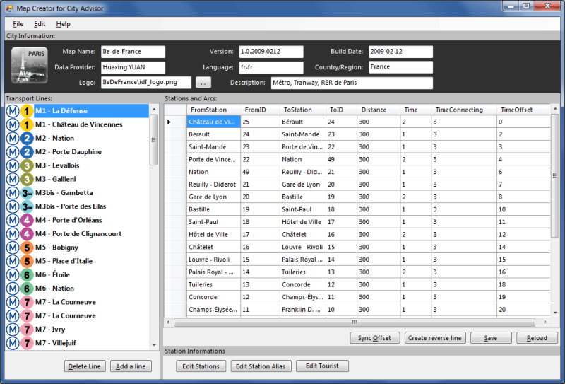
Map Creator for City Advisor Map Creator for City Advisor - Create public transportation maps for use with City Advisor.
What's New in This Release:
· Enable Special TimeTable editing.
· Enable customize peeks.
· Enable CAX format map generation.
· Enable Language-Code Selection for accent insensitive search.
· Accent insensitive station search
PocketMinesweeper Minesweeper for Pocket PC is a FREE minesweeper game which runs on touch screen devices. Minesweeper has a multi-language interface which includes English, French and Chinese (Simplified and Traditional). You have 4 different levels to face. This game is developed on the HTC Diamond devices and tested both on Diamond and Touch Dual
Map of Shanghai (Chinese) / China for City Advisor Map of Shanghai (Chinese) / China for City Advisor - A Chinese version of Shanghai / China Metro map with all updated 10 metro lines. Find station with first letter of pinyin, ex: the keyword of Shanghai Railway Station is hcz.
1. Download the map (zip file)
2. Extract the files in /CityAdvisor/maps
3. Open CityAdvisor -> Maps icon -> Menu -> Refresh
4
Map of Lyon / France for City Advisor Map of Lyon / France for City Advisor. This map includes: 4 Metro, 4 Tramway, 2 Funiculaire, 1 Rhonexpress and 2 Bus.
Instructions:
1. Download the map (zip file)
2. Extract the files in /CityAdvisor/maps
3. Open CityAdvisor -> Maps icon -> Menu -> Refresh
4


")

")

")

")
![USA-DC [District of Columbia] Map for EagleEye PDA Tracking System](https://static.mobyware.org/data/images/def_program_reduced.png "USA-DC [District of Columbia] Map for EagleEye PDA Tracking System")
 / Belgium (Belgique) for City Advisor")
 / France for City Advisor")


 / China for City Advisor")
