Platforms: iPhone, iPad, iPod Touch, Apple iPhone OS
Categories: Travel & Navigation
Upload date: 30 May 13
Developer: Visual IT
License: Commercial
Price: 2.99 $
Downloads: 25
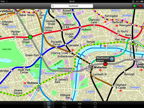
London Tube for iPad by Zuti - "London Tube 10" is a superb geographically based map and route planner for the London Underground, Overground, Docklands Light Railway (DLR), Croydon Tramlink and London Airport Express services. The map and routing information is stored completely on the device and needs no internet connection, making it ideal for iPad users visiting the UK who want to avoid paying roaming charges.
MAP
The map is hand drawn by Visual IT and provides a unique geographically based view of the city centre with many places of interest drawn directly on the background so you can easily get your bearings when traveling in and around the city. Tap on the map for location information, use the inbuilt search feature or choose from a list of locations. Places of interest, museums, hotels, parks, restaurant, shops, hospitals, streets, etc, are also included. The route planner will automatically suggest the nearest station to any place of interest you select.
MINUTE MAP
Another unique feature of is the “Minute Map” option which allows you to see the travel times from a start point to all other locations on the map. This can be very useful and is not available in any other product on the market.
INTERNET CONNECTION
The map and routing do not require an internet connection and you will not be charged data connection fees. This also means the application runs successfully underground.
ROUTING
Does not require an internet connection and will always be available to display a clear and detailed view of the city transport systems, plus list and animate the optimum route for your journey. Provides the fastest route calculations of any mobile routing application (virtually instantaneous) using actual published journey times with the ability to select the quickest route or the route with the least changes.
Comprehensive details of your planned route are provided, including changes, directions of travel, number of stops, predicted journey times, etc. Uniquely this application gives you “direction”, “towards” and “service frequency” information for each segment of the journey (not available on any other offline journey planner) for example “At Kings Cross change to the Hammersmith and City line (Eastbound) towards Barking for 3 stops. Service runs every 7 minutes” which is essential when finding the correct platform and connection. Also given are alternatives for each segment of the journey.
TRAIN + STATION EXITS
Contains simple information on every Tube station indicating what carriage to use for the most efficient exit or transfer. Just tap on a Tube station and scroll down to see the exit information for each platform.
LIVE INFO
When an internet connection is available, optional "Live Information" on the current state of the transport services can be viewed (and automatically saved for future reference) allowing you to plan your journeys in advance and avoid any potential delays. Unique to this application is the ability to turn off services that are out of action and automatically calculate an alternative route.
What's New in This Release:
· Updated map and routing
Like it? Share with your friends!
If you got an error while installing Themes, Software or Games, please, read FAQ.
Supported operating systems:
Apple iOS 10.x (iPad), Apple iOS 10.x (iPhone), Apple iOS 11.x (iPad), Apple iOS 12.x (iPad), Apple iOS 12.x (iPhone), Apple iOS 4.3.x (iPad), Apple iOS 4.3.x (iPhone), Apple iOS 4.3.x (iPod Touch), Apple iOS 5.0 (iPad), Apple iOS 5.0 (iPhone), Apple iOS 5.0 (iPod Touch), Apple iOS 6.0 (iPad), Apple iOS 6.0 (iPhone), Apple iOS 6.0 (iPod Touch), Apple iOS 7.0 (iPad), Apple iOS 7.0 (iPhone), Apple iOS 7.0 (iPod Touch), Apple iOS 8.x (iPad), Apple iOS 8.x (iPhone), Apple iOS 8.x (iPod Touch), Apple iOS 9.x (iPad), Apple iOS 9.x (iPhone), Apple iOS 9.x (iPod Touch)
Similar Software:
Wales Explorer Wales Explorer - Wales as part of the United Kingdom has long and deep links with the New World. Legendary for its connections with Avalon and other touchstones of British history, it is also marked indelibly with its now declined industrial history of shipping and mining
Packing Pro Packing Pro is a super-enhanced version of the popular, top-ranking Packing app
Google Places Google Places with Hotpot helps you discover nearby places you'll love. Quickly search for Restaurants, Cafes, Bars and other places, while on the go.
Google Places also makes it easy to quickly rate the places you visit
Eat Manhattan Eat Manhattan - Eight million New Yorkers need somewhere to eat. So do the nearly 50 million tourists that visit the city every year. As a result, Manhattan is home to thousands of dining options. The only problem: one false move and lunch means a day-old hot dog rescued from a vat of murky water
Fuerth World Travel Fuerth World Travel - Map with locate me function makes you free to move.
Background reading always accompanies you on your trip
Hotel Finder Hotel Finder is an easy-to use, quick, and convenient way to find a hotel near you. This is a free application, so be sure to check it out!
Hotel Mate quickly identifies your location and lets you choose the nearest hotel
TransitM&S Orlando TransitM&S Orlando - TransitM&S is an easy-to-use transit application that provides bus info LYNX Transit at the metro Orlando area.
The app is designed for offline use. It is ideal for iPod Touch users. Even for iPhone users, it is designed to save money because AT&T no longer offers the unlimited data plan
AddTo Chicago AddTo Chicago - shows you some of your favorite Chicago locations like Millennium Park, Navy Pier and the Art Institute, great public art like the Bean, the Picasso, the Four Seasons mosaic mural and less well known locations like Powell's bookstore and Lou Mitchell's. AddTo Chicago lets you create your own map, photo album and travel diary
Booking.com for iPhone/iPad 7. Booking.com for iPhone/iPad 7. - Booking.com allows you to quickly find and book hotels right from your iPhone, iPad or iPod touch. The app includes a database of more than 250,000 places to stay from all over the world, along with over 17 million guest reviews and more than 2.6 million hotel photos.
With Booking
Hotels by Orbitz for iPad Hotels by Orbitz for iPad - Simple, powerful, fast and fun. The free Orbitz app designed just for the iPad lets you shop and book hotels effortlessly -- on the couch or on the go. It delivers a vast selection of hotels, powerful comparison tools, and secure booking in just 3 taps
Other Software by developer «Visual IT»:
London Underground for iPad by Zuti London Underground for iPad by Zuti - "London Underground 10" is a superb map and route planner for the London Underground, Overground and Docklands Light Railway (DLR) services. So you can make a quick exit when you leave the train we have now added exit information for all stations on the London Underground
The Pad (V3) The Pad (V3) - The Pad... This simple yet invaluable application is the fastest way to write and draw on a Windows Mobile Professional / Pocket PC PDA or phone
London Congestion Charge Map (UIQ) London Congestion Charge Map (UIQ) - This map package is an essential addition to your Tube 2 maps if you drive in or around central London.
This reference map gives you a clear view of the area now covered by the congestion charge system, complete with a quick find utility to help you find any major road or street in and around the area
Barcelona Metro by Zuti Barcelona Metro by Zuti - The Barcelona Metro application is a superb geographically based map and route planner for the Barcelona TMB (Transports Metropolitan de Barcelona) Metro and Tram services. This application is one in a worldwide series of Zuti maps from Visual IT who have been producing public transportation maps for mobile devices for many years
Tube Vienna (iPhone) Tube Vienna (iPhone) is a superb interactive guide to the Vienna Metro (U-Bahn) and Vienna Tram (StrassenBahn) systems.
With no need for an internet connection Tube Vienna will always be available to display a clear and detailed view of the city transport systems, plus list and animate the optimum route for all your journeys
Tube 2 Atlanta (UIQ3) Tube 2 Atlanta (UIQ3) - This map package for Tube 2 consists of a fully scrollable detailed map of the Atlanta rail system.
Plan journeys on this system, list details of the quickest routes and see a superb animated display of your journey tracking around the system map
Tube 2 Boston Pro (Palm OS) Tube 2 Boston Pro (Palm OS) - This map package for Tube 2 consists of a fully scrollable detailed map of the Boston metro & commuter rail system and linked street maps of central Boston.
Plan journeys on the metro system, list details of the quickest routes and see a superb animated display of your journey tracking around the system map
Tube 2 San Francisco Pro (UIQ) Tube 2 San Francisco Pro (UIQ) - This map package for Tube 2 consists of fully scrollable detailed maps of the San Francisco metro & rail systems and linked high quality street maps of central San Francisco.
The maps in this package cover the BART, SCVTA & Caltrain systems plus the Municipal Metro, Municipal Historic Street Car and Cable Car systems in central SF
Tube 2 London Pro (Palm OS) Tube 2 London Pro (Palm OS) - This map package for Tube 2 consists of a fully scrollable detailed map of the London Underground system and 2 linked A-Z street maps.
Plan journeys on the London Underground system, list details of the quickest routes and see a superb animated display of your journey tracking around the system map
Tube New York City (Series 60) Tube New York City (Series 60) - Our highly acclaimed Tube application that guides you around the complex MTA subway system of New York City is now available for your Series 60 Symbian powered phone. An essential addition to your phone for locals and tourists alike.
· A detailed clear colour map of the transport system fully scrollable


")
")

")
")
")
")
")
")