Platforms: iPhone, iPad, iPod Touch, Apple iPhone OS
Categories: Travel & Navigation
Upload date: 28 Jun 11
Developer: Weather Decision Technologies
License: Commercial
Price: 3.99 $
Downloads: 25
iMapStorm - Actionable hurricane information when you need it most, directly to your iPhone.
Follow along through all of a hurricane's stages, accessing updates when the conditions are ripe for a tropical disturbance and the progression into a tropical depression. Track the next big Hurricane in real time and follow its predicted path, including vital statistics on predicted wind strength as the news breaks with briefings from the National Hurricane Center
You can explore rich and detailed radar images, satellite images and listen to real time video briefings. Or you can look at past Hurricanes by location and date for a sense of what’s to come.
Be the first to know, and the first to spread the word on the latest hurricane developments with iMAP Storm.
Disclaimer – iMAP Storm attempts to keep you updated with the latest information about the tropical situation. All official hurricane data originates from the National Hurricane Center (NHC). We strive to provide you with the best information available, however; do not make decisions or take actions solely based on this application, that would impact the safety and / or well-being of yourself or others in your care, as we can not guarantee the precision, accuracy, and latency of the data on which this product is based. Nor do we have control of the network connection that could directly impact the responsiveness of the information communicated.
Maps:
· From the Tropical Overview map, select active storms to get the current location statistics, forecast track, error fan and wind speed forecasts.
· Load radar maps to and zoom in to see where the precipitation is falling.
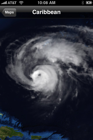
· View detailed satellite images from a selection of several regions to get the latest views of the tropics.
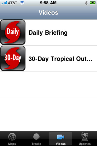
Videos:
· Watch the latest breaking videos and eye-witness reports on the tropical situation, from inception to the devastating wind and dangerous flooding in low-lying area.
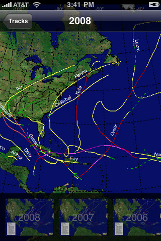
Tracks:
· Relive and explore hurricane history, simply choose the year and view the hurricane and tropical storm tracks for the Atlantic Basin.
Updates:
· Get the latest text and video information direct from the National Hurricane Center. Watch the latest video briefings and read the most informative reports from the forecasters at NHC.
What's New in This Release:
· Animated radar
· Animated satellite
· Additional satellite sectors
· Map rotation in the Maps section
· Additional text products
Like it? Share with your friends!
If you got an error while installing Themes, Software or Games, please, read FAQ.
Supported operating systems:
Apple iOS 10.x (iPad), Apple iOS 10.x (iPhone), Apple iOS 11.x (iPad), Apple iOS 12.x (iPad), Apple iOS 12.x (iPhone), Apple iOS 4.0.x (iPhone), Apple iOS 4.0.x (iPod Touch), Apple iOS 4.2.x (iPad), Apple iOS 4.2.x (iPhone), Apple iOS 4.2.x (iPod Touch), Apple iOS 4.3.x (iPad), Apple iOS 4.3.x (iPhone), Apple iOS 4.3.x (iPod Touch), Apple iOS 5.0 (iPad), Apple iOS 5.0 (iPhone), Apple iOS 5.0 (iPod Touch), Apple iOS 6.0 (iPad), Apple iOS 6.0 (iPhone), Apple iOS 6.0 (iPod Touch), Apple iOS 7.0 (iPad), Apple iOS 7.0 (iPhone), Apple iOS 7.0 (iPod Touch), Apple iOS 8.x (iPad), Apple iOS 8.x (iPhone), Apple iOS 8.x (iPod Touch), Apple iOS 9.x (iPad), Apple iOS 9.x (iPhone), Apple iOS 9.x (iPod Touch), Apple iPhone OS 3.1.x, Apple iPhone OS 3.1.x (iPod Touch), Apple iPhone OS 3.2.x (iPad)
Other Software by developer «Weather Decision Technologies»:
NewsOK weatherwatch Premium NewsOK weatherwatch Premium weatherwatch plus is a full featured weather application with tools to keep you informed of weather news, current conditions and forecasts.
The interactive radar map provides an up-to-date map of precipitation for anywhere in the U.S. Just type in your favorite location and see radar information and current conditions for that location
MyFoxHurricane MyFoxHurricane - Get immediate access to the latest news on hurricanes for the hurricane season, straight to your iPhone from the experts at the National Hurricane Center and MyFoxHurricane.com.
View the most up-to-date conditions and breaking news with exclusive MyFox Hurricane video reports and video briefings from hurricane specialists at the National Hurricane Center
FOX 25 Weather FOX 25 Weather is a full-featured weather application with the tools New Englanders need to keep an eye on the weather 24 hours a day.
· Track current conditions and long-range forecasts.
· Use interactive radar to see up-to-date maps of precipitation in your town and anywhere in the U.S
Storm Track 8 Weather Storm Track 8 Weather - STORM TEAM 8 LIVE WEATHER is a full featured weather application with the tools to keep you informed of Quad Cities weather news, current conditions and forecasts. An interactive Radar Map provides an up-to-date map of precipitation for anywhere in the U.S
Hunting Life Weather The Hunting Life Weather application displays up-to-date, detailed information in the form of current conditions, forecast and radar on an interactive map along with 7-day forecasts for the United States
5NEWS Severe Weather App 5NEWS Severe Weather App - 5NEWS HD Interactive severe weather center is a full featured weather application with the tools to keep you informed of weather news, current conditions and forecasts. The Max 5 Interactive Map provides an up-to-date map of precipitation anywhere in the U.S
WHNT News 19's iPad Weather App HD WHNT News 19's iPad Weather App HD - WHNT News 19's iPad Weather app is your information center for weather where you live. It has weather tools designed to keep you aware of the latest weather forecasts and advisories, current conditions, warning information and 7-day and extended outlooks
iMapWeather Lite iMapWeather Lite - iMapWeather is a sophisticated weather application that delivers the best interactive radar map on the iTunes store.
The application displays up-to-date, detailed information in the form of radar and clouds (satellite) on an interactive map, along with current conditions, 7 day, and hourly forecasts.
Receive timely weather alerts for your active location
Q13FOX Sun Tracker Q13FOX Sun Tracker - Need sunshine? Follow our Sun Tracker and find out when you'll need to apply sunscreen again. Plus, get instant Seattle and Puget Sound weather reports and forecasts with interactive/satellite maps, video, and warnings
iMap Weather iMap Weather Built upon state-of-the-science technologies, this multimedia weather platform provides location-based radar images, lighting strikes, current conditions and forecasts and allows you to pre-set additional locations of interest