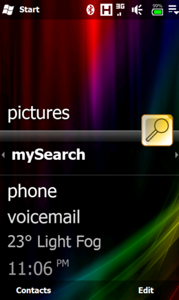
mySearch is a location-aware search application that uses Microsoft Bing to return results based on your current position. Just enter in your search term and press the search button to return location specific results!
If your device has HTC's G-Sensor service then simply orient the screen for landscape or portrait mode. Finger based scrolling/panning is also enabled on all devices that support it.
What's New in This Release:
Corrected bug in "back" logic when history was > 5 links
Like it? Share with your friends!
If you got an error while installing Themes, Software or Games, please, read FAQ.
Supported operating systems:
Pocket PC 2002, Windows Mobile 2003, Windows Mobile 5.0, Windows Mobile 6 Classic, Windows Mobile 6 Professional, Windows Mobile 6.1 Classic, Windows Mobile 6.1 Professional, Windows Mobile 6.5 Professional
Similar Software:
GPS2day GPS2day is a today screen plug-in showing your current GPS coordinates, speed, satellite info, etc...
Languages: English, Czech, Dutch, French, German, Hungarian, Italian, Japanese, Polish, Russian, Spanish.
Currently GPS2day program works as GPS informer. It supports both metric and U.S
GPSEphemeris GPSEphemeris uses the GPS on your PocketPC to download the hourly Ephemeris file from the GPS network. You can use this before you start other GPS applications to get a quicker GPS lock. NOTE: The ephemeris file expires after about 1 hour
PoliceGoogler PoliceGoogler uses the GPS on your PocketPC to find the 50 closest police services sorted via GPS distance. Tap the button to start the GPS and when you get a lock tap on it to view the list of local police services. You can also dial the numbers. The GPS maps and pig search service is provided by Google
ppc PhotoGeoTag ppc PhotoGeoTag - Take pictures with your mobile phone and incorporate the data of the geographical location. The application allows you to include in the photographs, data from the GPS receiver, along with a brief note. If you know the coordinates, not having the GPS receiver, you can also handwrite geographic data
Navigation BE-ON-ROAD DACH Q2/2011 Navigation BE-ON-ROAD DACH Q2/2011 - The new major version of be-on-road presents new features and is based on new platform which brings high level of reliability, portability and speed on almost any kind of device. The new be-on-road brings high value voice guided door-to-door navigation
FON Access Points for Hungary FON Access Points for Hungary - FON offers you a new Points of Interest service (POIs). This allows you to download FONspots directly to your navigation device.
What does that mean? You can download a Points of Interest file directly to your navigation device
WM MiniGPS WMMiniGPS is a Windows Mobile 5/6 software which gets your GPS data in a really simple gui, showing you latitude, longitude, laltitude and speed.
It can log all to file and it can export your paths to Google Earth's kml format, letting you to see where you've been, with different time intervals
BoatOdometers BoatOdometers - BoatOdometers uses the GPS on your PocketPC to measure your boat's speed and displays it in real time in Knots/hr, KM/hr and Miles/hr. The program also displays your latitude and longitude.
This program requires that you have both the 'BeanDLL.dll' file ** and ** the runtime files for Visual Basic on your PocketPC computer
Where I Am Where I Am - a small program using GPS and copies the coordinates in clipboard or builds a link for map in Google pointing to where you are now and saves it into clipboard again. Later all you have to do is only send this link. After installation you have to go to the folder containing this program, open settings
Other Software by developer «Sleuth255»:
ATI ImageON Fix ATI ImageON Fix - This application fixes the ATI ImageON acceleration bug. This is the bug that causes the screen to "tear" during accelerated video playback using CorePlayer, TCPMP or other players that take advantage of the ImageON hardware acceleration. Once this bug is occurring, the entire screen is unreadable until you somehow exit from the video player
myRadar myRadar is a location aware radar application that makes use of Wunderground and Accuweather US web services to show real-time, animated Radar Images of your local area regardless of where in the US you might be. This application requires myLocation services to function automatically.
The program will install to /Program Files/myRadar
PTTFix PTTFix - this little application replaces the Cingular PTT service and adds customizable launch capabilities back to that useless PTT button on your Cingular ROM equipped Hermes. This patch initially maps the PTT button to the built in Voice Dialer, but you can re-map the push as well as the hold functions to the application of your choice
SIPChange SIPChange - SIPChange is for those who can no longer change their defaultIM using the reghacks after upgrading to AKU2.x. No matter what you choose, the keyboard SIP is always selected after a soft reset.
If you aren't having this problem, then you don't need this little app
myLocation myLocation- It seems like websites and online services are popping up everywhere that can use location to give you more relevant information. Accuweather and others feature location aware weather sites and Google Maps can accept coordinate information to return location aware search results. Of course, with positional awareness comes controversy

")