Metro LX is a comprehensive guide to the Lisbon Subway providing:
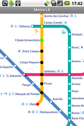
A map of Lisbon Metro (subway) in landscape and portrait modes;
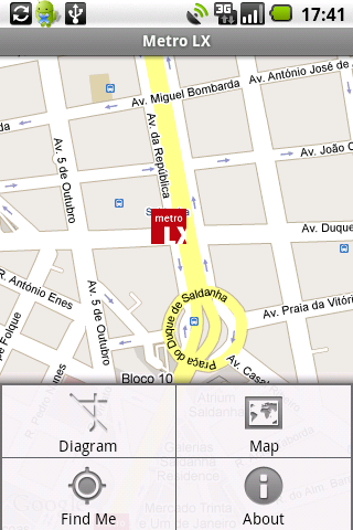
A route planner between stations;
A map route to station from your position;
And detailed information per Station.
What's New in This Release:
· Updated tariff (February 2012);
· Minor bugs fixed on tablets.
What's New in 2.8:
· Improved route to station planner;
· Updated tariff (August 2011);
· 3 new translations (Korean, Chinese and Romanian);
· Minor bugs fixed.
What's New in 2.6:
· Added preferences panel to disable/enable the use of GPS current location;
· Switch orientation crashes fixed.
What's New in 2.4:
· Minor bugs solved.
What's New in 2.3:
· Support for multiple screen sizes and resolutions.
· Layouts slightly restyled.
Like it? Share with your friends!
Supported operating systems:
Google Android 1.5, Google Android 1.6, Google Android 10.x, Google Android 2.0, Google Android 2.1, Google Android 2.2, Google Android 2.3, Google Android 3.0, Google Android 3.1, Google Android 3.2, Google Android 4.0, Google Android 4.1, Google Android 4.2, Google Android 4.3, Google Android 4.4, Google Android 5.x, Google Android 6.x, Google Android 7.x, Google Android 8.x, Google Android 9.x
Similar Software:
Google Maps (Android) Google Maps - Now you can get business locations, maps and directions while you're on the go. And it's all free.
· Navigation: Free, voice-guided GPS navigation system using GPS with Google Maps
· Places: Find nearby places and see hours, reviews, etc
Street View on Google Maps (Android) Street View on Google Maps (Android) - With Street View on Google Maps, explore the world at street level.
New! Street View smart navigation -- move around by dragging "Pegman" where you want to go.
Try Street View on Google Maps to view street-level imagery from your Android phone
AugSatNav Walk AugSatNav is an augmented reality navigation system which overlays walking directions upon a live video feed of the path or road ahead.
With AugSatNav there is no need to follow instructions or interpret maps - you can simply find your way by walking along the route highlighted by a bright white line
amAze (Motorola) AmAze is a first of its kind free navigation and local search service. It is free to download and use and it contains wide coverage of maps including aerial photo in Europe, North America, Australia and parts of Asia and Africa
Osm2GpsMid GpsMid is a free, fully offline, vector based map application for your mobile phone. It displays your current position on a zoomable map and can be used to search for and navigate to roads or points of interest of your liking. As all data is stored in a compact binary format on your mobile phone you will incur no charges for extra data downloads
Mobilex GPS Logger Mobilex GPS Logger - Overview ========================== The Android GPS Logger application captures GPS updates, and saves latitude and longitude coordinate fixes to text files on micro SD card. Supported Features inlcude: ============================== Google Maps. Satellite, Traffic and Street Views
WifiMapper - Free Wifi map WifiMapper - is a global map of free of charge Wifi access points all over the world. This application will help you find the nearby access points as well as type of facility (coffee houses, pubs, cinemas and so on). Besides, the list of access points has daily updates
amAze (Android) AmAze is a first of its kind free navigation and local search service. It is free to download and use and it contains wide coverage of maps including aerial photo in Europe, North America, Australia and parts of Asia and Africa
NAVIGON MobileNavigator NAVIGON MobileNavigator - Turn your Android phone into a mobile navigation device with lots of useful functions that will delight you! The pocket navigation device will show you the right way with functions such as Reality View Pro and Lane Assistant Pro

")


")
")

")


")

