US Terrain Intelligence for Android - The Outdoor Navigation software is your best friend through your adventures in the wild.
Go into the outdoors with confidence and enjoy your activities without worrying about the tools to help you navigate. Your Outdoor Navigation app is made by the people who have been developing this software since 2003 across multiple platforms. Be sure that you will stay ahead of the rest with continuous updates and relevant tools.
It is an excellent tool for biking, jogging, skiing, hiking, geocaching, boating, flying and many other sporting activities.
United States Terrain Intelligence will give you access to the most sophisticated Ground Guidance technology and allow you to take advantage of services that have only been available to military personal until now.
Terrain Intelligence takes into account a multitude of variables, including elevation, land cover and aerial aspects to calculate the best possible route.
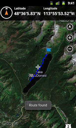
To plan your your off road activities:
· Select Terrain Intelligence as Routing Type in Options
· Route Settings
· Tap on the map to select start and end off road points
· Route will be calculated using Terrain Intelligence service
This plugin works only in the USA.
Installation instructions:
Outdoor US Terrain Intelligence is an add-on for the free Outdoor Navigation application. You need to have your Outdoor Navigation installed to be able to use Outdoor US Terrain Intelligence.
Download and install Outdoor US Terrain Intelligence on your Android device. Start the Outdoor US Terrain Intelligence plugin to complete the license checking: when activation will be completed then the icon will be removed (you need to restart your device to hide the icon) and the plugin will be used inside Outdoor Navigation application
What's New in This Release:
· Bug fixing
Like it? Share with your friends!
Supported operating systems:
Google Android 10.x, Google Android 2.1, Google Android 2.2, Google Android 2.3, Google Android 3.0, Google Android 3.1, Google Android 3.2, Google Android 4.0, Google Android 4.1, Google Android 4.2, Google Android 4.3, Google Android 4.4, Google Android 5.x, Google Android 6.x, Google Android 7.x, Google Android 8.x, Google Android 9.x
Similar Software:
Flightradar24 Free ★ 'Flightradar24 Free' shows airplane traffic around the world in real time! ★ ■ Flightradar24 is a flight tracker, that makes it possible to view airplane traffic, in real time, on a Google Map in your Android phone/tablet
Most Beautiful Valleys In The World Most Beautiful Valleys In The World - The world is a wonderful place. Today we decided to present you the most beautiful and famous valleys in the world. From the steep valleys of the Himalayas to the picturesque valleys found high in the Alps, these are many of the most beautiful valleys in the world
Location Info It gives you many interesting information about you location
City of Griffin City of Griffin - Public service one stop app for the City of Griffin, GA. Gives citizens the ability to quickly contact local government, police, and fire. App also offers the ability to pay bills, traffic citations, etc. Citizens can also report city issues like pot holes and damaged street lights through the app
Remember The Place Remember The Place - Ever want to come back to some cool places you've visited but you forgot the way to get back there?
Never let that thing happen again!
With this app installed on your phone, you will never forget any place you've visited last week, last month, even last year
Beautiful National Parks Beautiful National Parks - National parks are naturally beautiful. Most parks were declared parks to preserve the wild beauty that makes them so amazing. While nearly all these protected areas are pretty, a number are simply amazing in their beauty. Take a look at the list of the most beautiful national parks in the world
Hindu Festival Vasant Panchami Hindu Festival Vasant Panchami - Vasant Panchami marks the beginning of the spring season. In eastern parts of India, particularly in West Bengal, it is celebrated as Saraswati Puja. Sates of Punjab and Bihar, celebrate it as a festival of kites. However, during the ancient times, the festival was celebrated in the royal palace of Kamadeva
Rio Carnival Photos Get in the mood for the biggest party in the world - The Carnaval in Rio de Janeiro - with this picture gallery. Rio Carnival is as considered the biggest carnival in the world and as locals describe it "the greatest show on Earth"
LivingSocial LivingSocial - The best daily deals in your city from LivingSocial.
LivingSocial helps you discover the best of your city even when you’re on the go. We have the inside scoop on the best shopping, restaurants, activities and more—all handpicked, unique, and an incredible value
Other Software by developer «GPS Tuner»:
Outdoor Offline Maps for Android Outdoor Offline Maps for Android - The Outdoor Navigation software is your best friend through your adventures in the wild.
Go into the outdoors with confidence and enjoy your activities without worrying about the tools to help you navigate. Your Outdoor Navigation app is made by the people who have been developing this software since 2003 across multiple platforms
GPS Tuner Essentials Full Version with Iberia Basic Map Content GPS Tuner Essentials Full Version with Iberia Basic Map Content is designed specifically for off-road use: its large buttons, selectable tool window size, multiple Compass views and the built-in Tele Atlas map makes it extremely user-friendly and reliable
GPS Tuner Essentials Full Version with Italy and Malta Basic Map Content GPS Tuner Essentials Full Version with Italy and Malta Basic Map Content is designed specifically for off-road use: its large buttons, selectable tool window size, multiple Compass views and the built-in Tele Atlas map makes it extremely user-friendly and reliable
GPS Tuner Essentials Full Version with British Isles Basic Map Content GPS Tuner Essentials Full Version with British Isles Basic Map Content is designed specifically for off-road use: its large buttons, selectable tool window size, multiple Compass views and the built-in Tele Atlas map makes it extremely user-friendly and reliable
GPS Tuner Essentials Full Version with BENELUX Basic Map Content GPS Tuner Essentials Full Version with BENELUX Basic Map Content is designed specifically for off-road use: its large buttons, selectable tool window size, multiple Compass views and the built-in Tele Atlas map makes it extremely user-friendly and reliable
Outdoor Speedometer for Android Outdoor Speedometer for Android - The Outdoor Navigation software is your best friend through your adventures in the wild.
Go into the outdoors with confidence and enjoy your activities without worrying about the tools to help you navigate. Your Outdoor Navigation app is made by the people who have been developing this software since 2003 across multiple platforms
Outdoor Compass for Android Outdoor Compass for Android - The Outdoor Navigation software is your best friend through your adventures in the wild.
Go into the outdoors with confidence and enjoy your activities without worrying about the tools to help you navigate. Your Outdoor Navigation app is made by the people who have been developing this software since 2003 across multiple platforms
GPS Tuner Essentials Full Version with Canada Basic Map Content GPS Tuner Essentials Full Version with Canada Basic Map Content is designed specifically for off-road use: its large buttons, selectable tool window size, multiple Compass views and the built-in Tele Atlas map makes it extremely user-friendly and reliable
Outdoor Share for Android Outdoor Share for Android - The Outdoor Navigation software is your best friend through your adventures in the wild.
Go into the outdoors with confidence and enjoy your activities without worrying about the tools to help you navigate. Your Outdoor Navigation app is made by the people who have been developing this software since 2003 across multiple platforms
GPS Tuner Essentials Full Version with Central Europe Basic Map Content GPS Tuner Essentials Full Version with Central Europe Basic Map Content is designed specifically for off-road use: its large buttons, selectable tool window size, multiple Compass views and the built-in Tele Atlas map makes it extremely user-friendly and reliable