Athens Transportation - Information and tracking of buses, trolleys, tram, subway and trains lines/stops in Athens, Greece. English description at the end.
Η εφαρμογή περιέχει τις γραμμές και τις στάσεις όλων των μέσων αστικών συγκοινωνιών της Αθήνας (λεωφορεία, τρόλεϊ, τραμ, μετρό, ηλεκτρικός και προαστιακός).
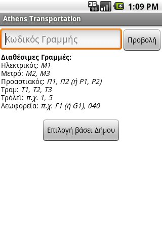
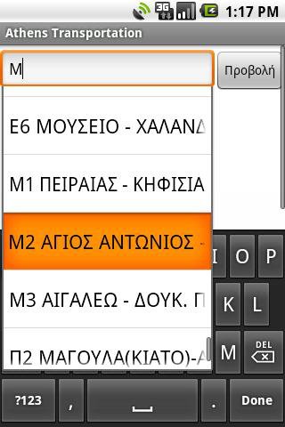
Δίνει την δυνατότητα στο χρήστη να επιλέξει τη γραμμή που επιθυμεί γράφοντας απευθείας τον κωδικό ή το όνομα της, είτε επιλέγοντάς την από τη λίστα βάσει του Δήμου που εξυπηρετεί.
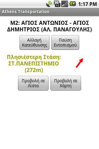
Στη συνέχεια μπορεί να δει ποια είναι η πιο κοντινή στάση στην τωρινή τοποθεσία του, με υπολογισμό της απόστασης από αυτή και ένδειξη της κατεύθυνσης, κάνοντας χρήση του ενσωματωμένου GPS και πυξίδας της συσκευής. (Απαιτεί να βρίσκεται σε απόσταση έως 1.5 χιλιόμετρο περίπου από την κοντινότερη στάση).
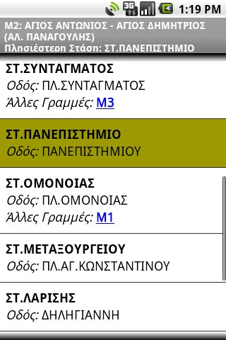
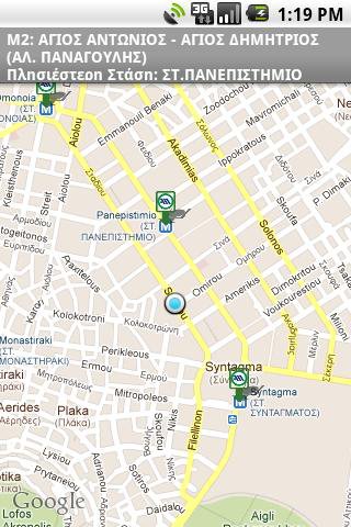
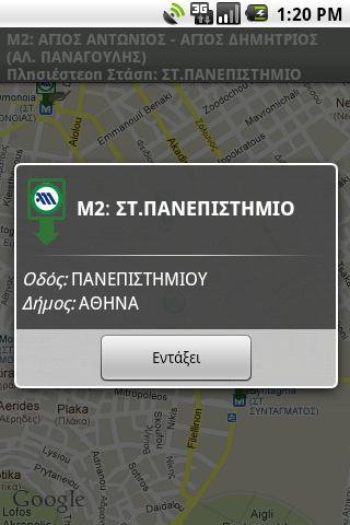
Οι στάσεις της επιλεγμένης γραμμής εμφανίζονται σε λίστα ή σε Χάρτη Google (απαιτεί σύνδεση στο Διαδίκτυο). Στη συνέχεια υπάρχει ενημέρωση σε πραγματικό χρόνο του ποια στάση βρίσκεται αυτή τη στιγμή και ποια είναι η επόμενη.
Επιπλέον Χαρακτηριστικά:
* Λειτουργεί χωρίς πρόσβαση στο Διαδίκτυο (εκτός των Χαρτών Google)
* Πολύ μικρό μέγεθος στη συσκευή, 200kb+, αν επιλεχτεί ως σημείο μεταφόρτωσης της βάσης η κάρτα μνήμης
Προσοχή:
* Η εφαρμογή περιέχει λάθη και παραλείψεις. Όταν συναντάτε κάποιο, επικοινωνήστε μαζί μου ώστε να το διορθώσω!
* Τα δεδομένα προέρχονται από την ιστοσελίδα του ΟΑΣΑ και περιέχουν επιπλέον διορθώσεις.
* Ο προγραμματιστής και η εφαρμογή ΔΕΝ έχουν καμία σχέση με τον ΟΑΣΑ.
* Ουδεμία ευθύνη φέρω για... αγνοούμενους στην Αθήνα :)
ENGLISH DESCRIPTION
The application contains the Lines and Stops off all public transports of Athens, Greece (busses, trolleys, tram, subway, electric railway and suburbian railway).
It lets user choose the Line they want, either by writing directly it's code or name, or selecting it from the list of municipalities it crosses.
Next they can see which is the closest stop to their current location, with calculation of distance and direction towards it, by using the embedded GPS and compass of the device. (It requires to be within a distance of about 1.5km (1 mile) from the closest stop).
The stops of the selected line can be displayed in a list or on Google Map (requires Internet connection). Then realtime information is displayed about which stop they are currently in and which stop comes next.
Additional Features:
* Works without Internet access (except for Google Maps)
* Very small installation footprint in device, 200kb+, if the External Storage is selected as the save point for the Database.
Note:
* The application contains errors and lacks information. When you come across any of them, contact me so I can fix them!
* The data originate from the website of OASA
http://www.oasa.gr
and contain additional fixes.
* The programmer and the application are NOT affiliated to OASA in any way.
* I can't be held liable for any... missing persons in Athens :)
Like it? Share with your friends!
Supported operating systems:
Google Android 1.5, Google Android 1.6, Google Android 2.0, Google Android 2.1, Google Android 2.2, Google Android 2.3, Google Android 3.0, Google Android 3.1
Similar Software:
Sydney Transportation Sydney Transportation - Off-line transport information system which runs on the Google Android, providing timetables for train lines, buses and even ferries in Sydney.
The system is designed to be flexible
KL Traffic Cam KL Traffic Cam is an Android application that provides easy access to excellent video feeds provided by ITIS. No fancy stuff here - an Intent is published with the video feed URI. This triggers an Android's built-in video component to start streaming video. The application also provides an embedded web view for quick access to ITIS' WAP site and a favorites list
TorontoBusMap TorontoBusMap - TorontoBusMap shows locations and predicts bus times in Toronto using GPS info from the Toronto Transit Commission.
What's New in This Release:
· GPS now turns on when you start the app to allow quicker location lookup times
RATB SMS RATB SMS - Using this application, one will be able to buy a 1 day transportation pass for RATB (Regia Autonoma de Transport Bucuresti).
The application sends an SMS and displays the received confirmation code for the acquired pass
Eigene Anreise - Urlaubssuche Mit dieser App können Sie nach Reiseangeboten für Ihren Urlaub mit eigener Anreise per Auto, Bahn oder Flug suchen und sich über einen Preisvergleich Angebote der verschiedenen Reiseveranstalter zu den einzelnen Hotels anzeigen lassen
Radisson Blu Milan Radisson Blu Milan - App Radisson Blu Hotel Milan.Near Milan's bustling Viale Certosa and close to the city centre, this hotel is 41 kilometres from Malpensa Airport and only three kilometres from Fiera Milano exhibition centre. The 250 radiant rooms and suites include appealing amenities like Free high-speed, wireless Internet and flat-screen televisions
Yurtdisina Çikma Rehberi Yurtdisina cikarken ihtiyaciniz olan her seyi detayi ile bulabileceginiz guncel bir uygulama
Berlin Metro This app grants you fast acces to the last Berlin Metro map, no internet connection needed once it has been installed. Full zoom controls. Fast, light and simple
iCommuteLess Lite iCommuteLess Lite - How much time do you spend commuting? Daily, weekly?
Where are you losing time in traffic?
Which route should you take at a given time?
Would you like to know the answers to these questions?!
Try iCommuteLess. Track daily commutes and derive intelligent feedback
Hotel Direct Save money by dealing with hotels direct. Send several requests and choose the best offer
Other Software by developer «Kostas Tzounopoulos»:
not found
Comments on Athens Transportation:
Comments not found
If you noted an error or download link is broken, please, report it via this page or use comments.
Athens Transportation is compatible with your device Huawei Ascend Q M660