VGPS (Vietnamese GPS) for Android was designed to use city street map on your ordinary mobile phone without the need of having GPS receiver or internet connection. VGPS does not require internal or external GPS receiver. However, if you have internal GPS receiver or external bluetooth GPS receiver, VGPS can work with your GPS receiver as well. VGPS does not require internet connection so you no need to worry about connection charge.
· Offline map (totally offline application. VGPS only uses internet to validate your purchase when you activate demo version become full version. Other than that the application will never use internet)
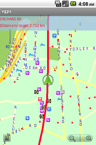
· Map data from Garmin and OpenStreetMap
· Zoom in/Zoom out/Pan
· Search point by name,type,distance or mix type+name, type+distance
· Can touch any object on the map
· GPS real-time tracking
· Routing point to point
· Rotate map so the driving direction (heading) is always up
· Voice guidance (turn left/turn right)
What's New in This Release:
· User can take screenshot and save to memory card
What's New in 7.0:
· Supports all android phones and tablets screen sizes and densities (android 1.5 to android 3.2+)
What's New in 6.9:
· pinch to zoom in/out
Like it? Share with your friends!
Supported operating systems:
Google Android 1.5, Google Android 1.6, Google Android 10.x, Google Android 2.0, Google Android 2.1, Google Android 2.2, Google Android 2.3, Google Android 3.0, Google Android 3.1, Google Android 3.2, Google Android 4.0, Google Android 4.1, Google Android 4.2, Google Android 4.3, Google Android 4.4, Google Android 5.x, Google Android 6.x, Google Android 7.x, Google Android 8.x, Google Android 9.x
Similar Software:
Navizon for Android Navizon for Android is an on-demand location system based on push-technology. Once it is installed, Navizon will let you track the mobile device's location with a click of a button. This can be especially useful if you lost your phone or if you are trying to locate a friend
Nav4All (Android) With Nav4All you can navigate worldwide on your own mobile phone.
You will never lose your way again and you will always know where you and your friends are located.
You get access to over 1 billion addresses on MyWorld, including Yellow Pages, phonebooks, etc.
While you're on the road you can easily save an interesting location by pressing one button
POSIT POSIT (Portable Open Search and Identification Tool) is a Humanitarian Free and Open Source Software project to use the Google Android phone as a platform for mobile disaster management applications
Maps In My Pocket (MIMP) Maps In My Pocket - The main goal of this application is to allow its users to view maps, locate themselves, follow KML or GPX formatted tracks and getting directions from place to place.
What's New in This Release:
· New Icon
What's New in 1.4.3:
· Long press and long pinch concurrency on info bubble solved
TomTom Poland for Android TomTom Poland for Android - TomTom Poland is a turn-by-turn GPS navigator for Android devices. The app includes accurate offline maps, so you can find your way anywhere, even without an internet connection
My GPS Coordinates and Location My GPS Coordinates and Location - A simple application with crude, but adequate, support for 40 languages. Allows you to share your position via email, text message, twitter, etc, and displays your current GPS location in both decimal format and in sexagesimal (degrees minutes seconds) format. Internet access is not required to send your location with a text message
MapMyFitness+ for Android MapMyFitness+ for Android - MapMyFitness is a fitness assistant that allows you to track your workouts using your phone's built-in GPS.
With the app you can view your route on a map and record your workout details, including duration, distance, pace, speed, elevation and calories burned
Polaris Navigation System Polaris Navigation System - The Polaris Navigation System is a powerful navigation software for Android. It includes all the standard GPS functionality, including an odometer, altimeter, speedometer and directional compasses.
The app also allows you to record trails and view them on a map
Sygic: GPS Navigation Sygic: GPS Navigation - Sygic is the premium turn-by-turn GPS navigation app. Sygic boasts an intuitive interface: drag the map, pinch to zoom, change point of view using built-in compass and tap target square to choose action. Sygic is comfortable and safe: advanced routing is optimized for Real-Time Traffic
GPS Signal Widget GPS Signal Widget - Do you get tired waiting for the GPS location to be available? With this tool you can check out the GPS satellites and the signal strength in just a nice 1X1 widget.
The spokes in the widget represents the satellites and the length of the spokes is a measure of the signal strength.
Enable or disable the widget by tapping on the widget
Other Software by developer «Vietnamese GPS»:
VGPS (Vietnamese GPS) VGPS (Vietnamese GPS) - was designed to use city street map on your ordinary mobile phone without the need of having GPS receiver or internet connection. VGPS does not require internal or external GPS receiver. However, if you have internal GPS receiver or external bluetooth GPS receiver, VGPS can work with your GPS receiver as well
VGPS (Vietnamese GPS) for Android VGPS was designed to use city street map on your ordinary mobile phone without the need of having GPS receiver or internet connection. VGPS does not require internal or external GPS receiver. However, if you have internal GPS receiver or external bluetooth GPS receiver, VGPS can work with your GPS receiver as well

")
 for Android")
 for Android")

")

")


")
 for Android")