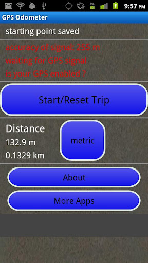
GPS Odometer - A simple and easy to use odometer. There is no maze of menus and no mysterious settings. GPS Odometer only does one thing, and does it well: measure distance traveled.
Note: Intended to measure relatively short distances, the application does not run in the background.
Like it? Share with your friends!
Supported operating systems:
Google Android 1.6, Google Android 10.x, Google Android 2.0, Google Android 2.1, Google Android 2.2, Google Android 2.3, Google Android 3.0, Google Android 3.1, Google Android 3.2, Google Android 4.0, Google Android 4.1, Google Android 4.2, Google Android 4.3, Google Android 4.4, Google Android 5.x, Google Android 6.x, Google Android 7.x, Google Android 8.x, Google Android 9.x
Similar Software:
GPS Location Lite GPS Location Lite - Use your Android phone as a professional GPS logging device.
Record different tracks and export gpx-files to sdcard.
View Distance, Time, Speed, Altitude, Latitude and Longitude.
In the GPS Location Lite settings you could choose gps or network provider. GPS interval (5-60 seconds) and some other preferences are adjustable
Geopaparazzi Geopaparazzi is a tool developed to do fast qualitative technical and scientific surveys. Its strength is its direct connection to the BeeGIS GIS, that can be used to further process the collected data.
Even if the main aim is in the field of surveying, it contains tools that can be of great use also to tourists that want to keep a geo-diary
amAze (Motorola) AmAze is a first of its kind free navigation and local search service. It is free to download and use and it contains wide coverage of maps including aerial photo in Europe, North America, Australia and parts of Asia and Africa
SOS App SOS App - This app sends a text message with your GPS position (address from google maps, latitude, longitude and accuracy).The use is simple. You have to choose a contact (with the search button) and then touch the picture
Mobilex GPS Logger Mobilex GPS Logger - Overview ========================== The Android GPS Logger application captures GPS updates, and saves latitude and longitude coordinate fixes to text files on micro SD card. Supported Features inlcude: ============================== Google Maps. Satellite, Traffic and Street Views
AugSatNav Walk AugSatNav is an augmented reality navigation system which overlays walking directions upon a live video feed of the path or road ahead.
With AugSatNav there is no need to follow instructions or interpret maps - you can simply find your way by walking along the route highlighted by a bright white line
POSIT POSIT (Portable Open Search and Identification Tool) is a Humanitarian Free and Open Source Software project to use the Google Android phone as a platform for mobile disaster management applications
Navitel Navigator for Android Navitel Navigator for Android - Navitel Navigator is a GPS travel assistant for Android. The app turns your phone into a personal navigation system.
Navitel Navigator comes with detailed maps and other useful features, including traffic jams, speedcams, 3D roads and intersections, instant routing and a comprehensive database with points of interest
Open GPS Tracker Open Source recording, storing and accessing of your routes: Open GPS TrackerAn application that can track your travels of your Android by storing your GPS locations. Draws the route real-time on either Google or OSM maps
AntipodalPoint AntipodalPoint retrieves you position from the network provider or GPS and calculates and shows you antipodal point - the place exact opposite of you on Earth.
AntipodalPoint Pro enables you to browse the entire world and find antipodal points
Other Software by developer «TappiApps»:
GPS Tape Measure GPS Tape Measure - GPS Tape Measure is a virtual tape measure for your Android device. Perfect for when you want to easily find the distance between two points on earth and you forgot to bring your laser rangefinder. Simple and easy to use
My GPS Coordinates and Location My GPS Coordinates and Location - A simple application with crude, but adequate, support for 40 languages. Allows you to share your position via email, text message, twitter, etc, and displays your current GPS location in both decimal format and in sexagesimal (degrees minutes seconds) format. Internet access is not required to send your location with a text message
Name That Plane Name That Plane - Test your knowledge of aircraft. The app features over 300 aircraft images. Compete with your friends and the world via a global score board provided by Scoreloop.
How score is calculated:
score = (percentage_correct * 10) / sqrt(sqrt(time_in_seconds))
Note that only thinking time is considered


")


