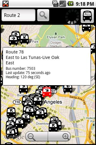
Los AngelBus - This application shows locations and predicts bus times in Los Angeles using GPS info from the Los Angeles Metro.
What's New in This Release:
· GPS now turns on when you start the app to allow quicker location lookup times. NOTE: There is also a new checkbox in the settings to disable this if you do not want it
· all stops mode added! This will show and update all bus stops around the center of the screen, not just ones on your current route. May be slow for older phones
· recently updated stops are temporarily colored green to show that they've updated
· search now searches stop titles in addition to routes
What's New in 4.01:
· updating to use new live bus schedule
What's New in 3.32:
· you can now show only a specific route in the 'more info' screen
Like it? Share with your friends!
Supported operating systems:
Google Android 1.5, Google Android 1.6, Google Android 10.x, Google Android 2.0, Google Android 2.1, Google Android 2.2, Google Android 2.3, Google Android 3.0, Google Android 3.1, Google Android 3.2, Google Android 4.0, Google Android 4.1, Google Android 4.2, Google Android 4.3, Google Android 4.4, Google Android 5.x, Google Android 6.x, Google Android 7.x, Google Android 8.x, Google Android 9.x
Similar Software:
Sutton Bay Sutton Bay is a private membership club, focusing on golf, hunting, fishing, horseback riding, and other activities. The app is designed to allow Sutton Bay Members to access the website, call the club, get on Twitter and Facebook, provide directions for their guests, view the calendar of events, see package pricing deals,and sign up for reservations
TrafficDroyd TrafficDroyd - real-time traffic information for the countries of Germany, Netherlands and Belgium.
Display traffic messages both in compact and full view:
· road name (e.g. "A8")
· road segment (e.g
SBS Transit iris SBS Transit iris - iris is the acronym for "Intelligent Route Information System" which provides bus travel information to enhance commuters' travel experience with SBS Transit. iris offers two applications to help the commuters better plan their journeys: a) iris NextBus and b) iris Journey Planner
KAYAK Lite KAYAK Lite Flight, Hotel, Car Search plus Flight Tracker. FREE.
If you need quick access to KAYAK travel search functions, this is the app for you.
Flight Search - find the best flight options for your trip.
Hotel Search - get the hotel that is right for you: 5-star or budget, we'll find it
Police traps & Speed cams Police traps & Speed cams - Police traps, speed cameras, speed cams, speed traps, ticket, fine, parking
Don't get any more speeding tickets or parking violations.
"Police traps and Speed cams" shows police traps, poslice radar, speed cams, speed traps, parking wardens, speed cameras, accidents and other traffic disturbances added by application users
Hong Kong Transport Hong Kong Transport - Hong Kong Transport App provides a useful guide for you to go around Hong Kong streets by public transport
Parkade App This app will help users get info about the nearest parkade
SimiValley Transit SimiValley Transit - Get real time departure information and vehicle tracking for Simi Valley Transit.
Program Features:
-----------------
1) Track real time departures for Simi Valley Transit agency.
2) Set up reminders for the earliest next departure for any stop, any route
Smartive Hotels: Free Hotel Booking App Install Smartive Hotels to book a hotel of your dream now!Over 140,000 hotels, special rates, great comparison tools, and more! Smartive Hotels is a free hotel booking app that lets you easily find and securely book hotels worldwide in just a couple of taps
Travelmuz App Travelmuz App - After the release of the website and the blog "travelmuz" pleased to present its mobile application. Discover all our Current news through this app that will satisfy you inshallah. Enjoy your visit you and see you soon on our website: www.travelmuz
Other Software by developer «George Schneeloch»:
UMichBusMap An Android application which shows the live positions of University of Michigan buses overlayed on Google Maps
TorontoBusMap TorontoBusMap - TorontoBusMap shows locations and predicts bus times in Toronto using GPS info from the Toronto Transit Commission.
What's New in This Release:
· GPS now turns on when you start the app to allow quicker location lookup times
BostonBusMap BostonBusMap is an application for Android phones. It uses GPS data provided by the MBTA to plot the real-time location of buses on a map.
What's New in This Release:
· GPS now turns on when you start the app to allow quicker location lookup times

")