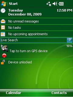
GPS2day is a today screen plug-in showing your current GPS coordinates, speed, satellite info, etc... Languages: English, Czech, Dutch, French, German, Hungarian, Italian, Japanese, Polish, Russian, Spanish.
Currently GPS2day program works as GPS informer. It supports both metric and U.S. (Imperial) units and shows a various types of information for users, such as:
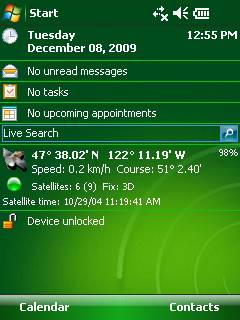
Current geographical coordinates (latitude, longitude);
Course and speed;
Some information about satellites and fix type;
Altitude followed by the fix 3D value;
Exact current date and time from the satellite atomic clock;
And battery life state which is important when you using GPS device.
What's New in This Release:
· Translation to Japanese was added
Like it? Share with your friends!
If you got an error while installing Themes, Software or Games, please, read FAQ.
Supported operating systems:
Windows Mobile 5.0, Windows Mobile 6 Classic, Windows Mobile 6 Professional, Windows Mobile 6.1 Classic, Windows Mobile 6.1 Professional, Windows Mobile 6.5 Professional
Similar Software:
SatTracx Mobile Locator SatTracx Mobile Locator helps to know your location or the whereabouts of your family, friends or your assets at anytime.
You can locate your loved ones – your children, elderly or patients at any given moment. You can also find where your buddies are and connect with them
FON Access Points for Afghanistan FON Access Points for Afghanistan - FON offers you a new Points of Interest service (POIs). This allows you to download FONspots directly to your navigation device.
What does that mean? You can download a Points of Interest file directly to your navigation device
PoliceGPSings PoliceGPSings - PoliceGPSings can be used by a Police officer to create dated GPS POI based note logs. For each GPS area you can create a log of reports from the area. The program uses the GPS on the PocketPC to find the distance of each GPS POI point and you can view or download the map the points on Google.com map service
GPark GParkS - The other day I was at a football game where I had to park on a golf course far from the stadium and ended up wandering around for 20 minutes trying to locate the car afterward
CalculatorGPSed CalculatorGPSed - CalculatorGPSed is a GPS distance calculator and location finder. You can use the GPS or custom entry on your PocketPC to view and download GPS marked satellite camera pictures and calculates distance between two points specified by the latitude/longitude using "The Vincenty inverse formula for ellipsoids" (accuracy to within 0.5mm, or 0
FON Access Points for Italy FON Access Points for Italy - FON offers you a new Points of Interest service (POIs). This allows you to download FONspots directly to your navigation device.
What does that mean? You can download a Points of Interest file directly to your navigation device
Kai's GPS Tracker.Net With the GPS Tracker you send your Position via 'SMS' or 'SMS to e-mail' to another person and tell him/her so your location. The recipient gets a SMS or e-mail with the location and a link to a map (on PC). Use it for your friends, family or in a company. Also suited to send holiday greetings from a foreign country
FON Access Points for Netherlands FON Access Points for Netherlands - FON offers you a new Points of Interest service (POIs). This allows you to download FONspots directly to your navigation device.
What does that mean? You can download a Points of Interest file directly to your navigation device
Medical Emergency BOT With only one touch of your mobile device,
you send Emergency Alert, with your current localization and personal data.
This program has simply interface, and it's easy, intuitive in using.
After you set it correctly, you will not do too much.
Just one touch when necessary
GPS Converter GPS Converter for Garmin, iGo, SpeedNavi and Powermap
Other Software by developer «Soft Expanse Group»:
ShellSwitcher ShellSwitcher was implemented as a Windows Mobile system utility for fast switching between well known shells: Spb Mobile Shell, Titanium (WM6.5 default shell), Touch Flo 3D, HTC Sense and classic Today screen. This application is based on UI Switcher knowledge with some additional features