Great Britain Rail for iPad by Zuti - The new Great Britain Rail map makes it easy to travel in and around the country using the rail services. This application contains a geographically accurate map of the whole of Great Britain allowing you to easily view the route of any journey. The routing and map are contained within the application and no internet connection is required to use these features.
MAP
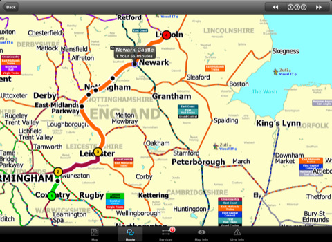
The map is hand drawn by Visual IT and provides a unique geographically based view of the Great Britain rail system. You can also use your inbuilt GPS to accurately locate and track yourself and see the nearest transportation stop and distance to it. This is the only rail transportation route planner with this ability. Tap on the map for location information, use the inbuilt search feature or choose from a list of locations.
MINUTE MAP
Another unique feature is the “Minute Map” option which allows you to see the travel times from a start point to all other locations on the map. This is a great way to view the topology of the country and gauge traveling times.
ROUTING
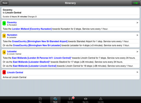
The application does not require an internet connection for routing and will always be available to display a clear and detailed view of the various rail operating company systems, plus list and animate the optimum route for your journey. This product provides the fastest route calculations of any mobile routing application using actual published journey times with the ability to select the quickest route or the route with the least changes.
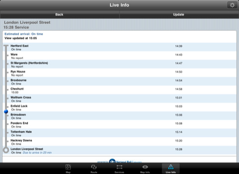
LIVE INFO
When an internet connection is available the user can check train arrivals and departures with live data supplied by National Rail Enquiries. Also shown is the estimated current real time position of the train for any of the listed services.
· The only rail app with a rail map.
· Full offline map and routing, works anywhere, no internet connection required.
· Designed for the first time visitor and experienced commuter.
· Simple, fast and intuitive to use.
· Colourful clear custom drawn geographically accurate mapping.
· Animates the route and allows tracking of the journey using GPS.
· Instantly see the route of any transport service drawn on the map.
· Save and recall favourite and recent journeys.
· One touch take me home feature.
· Unique "Minute Map" feature allows quick view of all journey times from a start location.
· Services can be turned on or off, routing round problems.
· Works on any iPad with iOS 3.2 or above.
· GPS location and tracking.
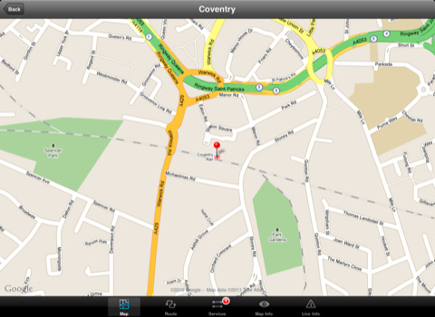
· View station locations on a Google map (internet required).
· View Live train departures and arrivals (internet required, live data supplied by National Rail Enquiries).
Like it? Share with your friends!
If you got an error while installing Themes, Software or Games, please, read FAQ.
Supported operating systems:
Apple iOS 10.x (iPad), Apple iOS 11.x (iPad), Apple iOS 12.x (iPad), Apple iOS 4.2.x (iPad), Apple iOS 4.3.x (iPad), Apple iOS 5.0 (iPad), Apple iOS 6.0 (iPad), Apple iOS 7.0 (iPad), Apple iOS 8.x (iPad), Apple iOS 9.x (iPad), Apple iPhone OS 3.2.x (iPad)
Other Software by developer «Visual IT»:
Digital Camera Guide (UIQ) Digital Camera Guide (UIQ) - An essential guide for anyone new to the world of digital photography. In a simple easy to read format with superb photographs it helps you to get the most from your camera and explains how many of the complicated features of your camera work.
Index of subjects covered:
- Camera Controls
Berlin Metro by Zuti Berlin Metro by Zuti - The new Berlin Metro map makes it easy to travel in and around the city using the Metro (U-Bahn) Suburban Rail (S-Bahn) and Tram (MetroTram and Straßenbahn) systems
Tube Singapore (Series 60) Tube Singapore (Series 60) - Our highly acclaimed Tube application that guides you around the metro system of Singapore is now available for your Series 60 Symbian powered phone. An essential addition to your phone for locals and tourists alike.
· A detailed clear colour map of the Singapore metro system fully scrollable.
· Quick find station utility
Barcelona Metro 10 for iPad Barcelona Metro 10 - This Zuti application contains a visually unique map of the Barcelona transport system and a superb animated journey planner to help you get around the TMB (Transports Metropolitan de Barcelona), FGC (Ferrocarrils de la Generalitat de Catalunya) Metro and Tram services
Tube Moscow (UIQ) Tube Moscow (UIQ) - Our award winning and highly acclaimed application that guides you around the complex metro system of Moscow is now available for your Symbian UIQ phone.
An essential addition to your P800 / P900 / P910 if you travel in or around this city
· A detailed clear colour map of the Moscow metro system fully scrollable
Tube Lisbon (Palm OS) Tube Lisbon (Palm OS) - An award winning and highly acclaimed Palm OS application that guides you around therail system of Lisbon. An essential addition to your Palm device for locals and tourists alike.
Tube's features include:
A detailed clear colour (or grey scale) map of the transport system fully scrollable.
Quick find station utility
Tube 2 London Geo (UIQ) Tube 2 London Geo (UIQ) - This superb map package for Tube 2 is the ideal map for anyone who needs to get around London using the underground system and would like to know just exactly where they are.
The map geographically accurately locates the central London stations, overlaid onto a street map. Now you can easily see how these stations fit into the real world
Tube 2 Baltimore (UIQ3) Tube 2 Baltimore (UIQ3) - This map package for Tube 2 consists of a fully scrollable detailed map of the Baltimore metro & rail system.
Plan journeys on this system, list details of the quickest routes and see a superb animated display of your journey tracking around the system map
Tube 2 Madrid Pro (UIQ) Tube 2 Madrid Pro (UIQ) - This map package for Tube 2 consists of a fully scrollable detailed map of the Madrid metro system and linked street maps of central Madrid.
Plan journeys on the metro system, list details of the quickest routes and see a superb animated display of your journey tracking around the system map
Madrid Metro by Zuti Madrid Metro by Zuti - The new Madrid Metro 10 map makes it easy to travel in and around the city using the the Metro, Renfe Rail and Metro Ligero Rail services. Unlike old fashioned schematic style maps this product contains a geographically accurate central area showing major streets, parks and places of interest etc, allowing the user to easily get their bearings


")

")

")
")
")
")
")
